
TYPHOON QUINTA (MOLAVE) ADVISORY NO. 08Issued at: 7:00 AM PhT (23:00 GMT) Monday, 26 October 2020
Next update: 1:00 PM PhT (05:00 GMT) Monday, 26 October 2020 |
|
|---|---|
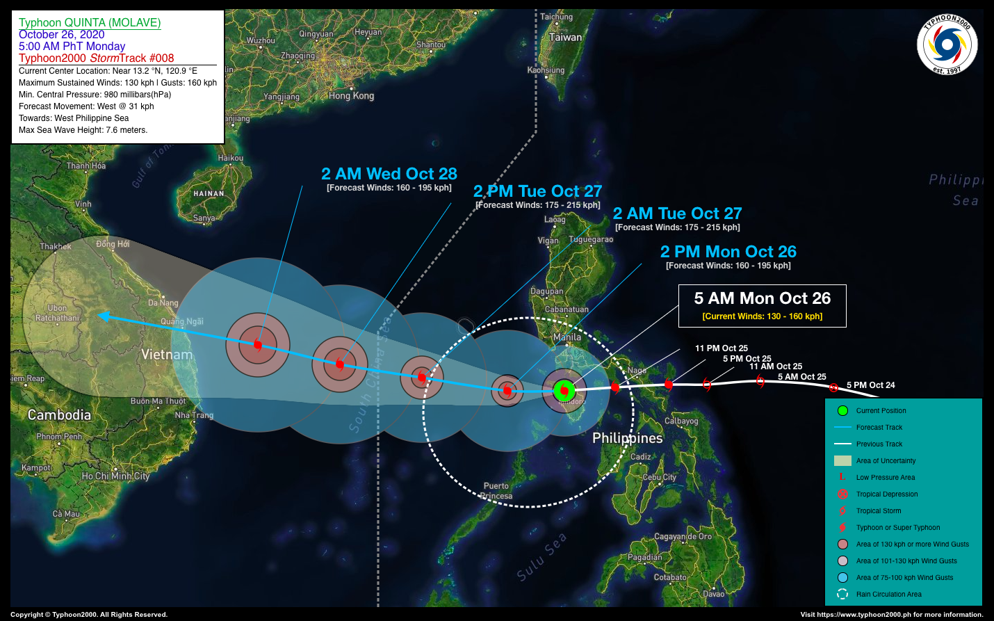
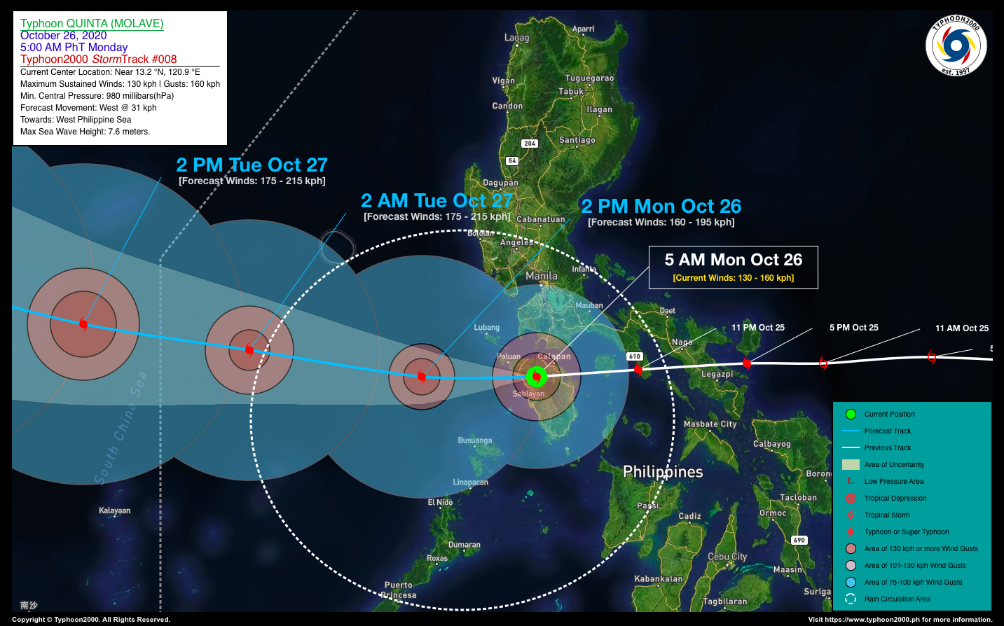
| Current Status and Outlook | Typhoon QUINTA (MOLAVE) now traversing the northern part of Mindoro as it continues to move rapidly westward in the general direction of the West Philippine Sea.
24-hr Outlook: TY QUINTA (MOLAVE) is forecast to emerge over the West Philippine Sea later this morning as it will begin to move on west to west-northwest track with a forward speed of 25 km/hr. It will continue to intensify reaching Category 3 status, and is expected to move out of the Philippine Area of Responsibility (PAR) by tomorrow morning (Oct 27). |
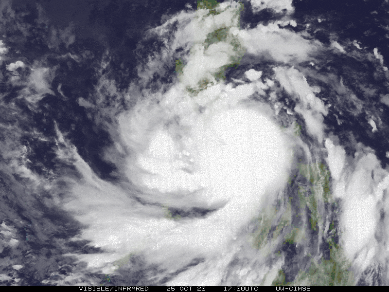
| Where is QUINTA (MOLAVE)? | As of 5:00 AM PhT today, October 26…2300 GMT. The cloud-filled eye was located over Mount Halcon or along the Oriental Mindoro-Occidental Mindoro Boundary (near 13.2°N 120.9°E), about 39 km southwest of Calapan City, Oriental Mindoro or 33 km north of Sablayan, Occidental Mindoro. |
| How strong is it? | Maximum Sustained Winds (1-min avg): 130 kph near the center…Gustiness: 160 kph. |
| Past Movement (06 hrs) | West @ 31 kph, towards the West Philippine Sea |
| Potential Philippine Landfall Area(s) | :: None |
| What Philippine areas will be directly affected? | Heavy to Extreme Rains (50 mm to >100 mm expected in 24 hrs): >> CaLaBaRZon, Mindoro, Marinduque, Romblon, Northern Palawan including Calamian Island Group – this morning until the afternoon. Damaging Winds (gusts of more than 100 km/hr expected): |
| Potential Storm Surge/Coastal Flooding Areas+ | :: Coastal Areas of MiMaRoPa & CaLaBaRZon – Today.
+Waves of 3 meters in height is expected in storm surge-prone areas, particularly in coastal areas on where the Tropical Cyclone is headed. Kindly visit the PAGASA Storm Surge Updates for more details. |
| 2-Day Forecast Outlook Summary** | TUESDAY EARLY MORNING: Rapidly intensifies to a strong Category 2 Typhoon as it is about to exit the western border of PAR…about 507 km W of Metro Manila [2AM Oct 27: 13.6°N 116.4°E @ 175 kph]. Confidence Level: HIGH
WEDNESDAY EARLY MORNING: Already outside of the Philippine Area of Responsibility (PAR) as it approaches Eastern Vietnam while weakening slightly…about 362 km ESE of Da Nang, Vietnam [2AM Oct 28: 14.6°N 111.2°E @ 160 kph]. Confidence Level: MEDIUM **Important Note: Please be reminded that the Forecast Outlook changes every 6 hours, and the Day 2 and 3 Forecast Track have an average error of 100 and 250 km respectively… while the wind speed forecast error, averages 35 km/hr per day. Therefore, a turn to the left or right of its future track and changes in its wind speed must be anticipated from time to time. |
| Other Storm’s Meteorological Info | > 24 hr. Rain Accumulation (across its circulation): 25 to 300 mm [Light to Heavy]
> Minimum Central Pressure: 980 millibars (hPa) > Size of Circulation [Convective Cloud-Based, in diameter]: 580 km (Medium) > Area of Damaging Winds (100 kph or more wind gusts): 110 km from the center. |
| Current Summary/Additional Reference Points | Time/Date: 5:00 AM PhT Mon October 26, 2020 Location of Center/Eye: Near 13.2°N Lat 120.9°E Lon Distance 1: 45 km E of Mamburao, Occidental Mindoro Distance 2: 83 km SSE of Calatagan, Batangas Distance 3: 70 km S of Batangas City, Batangas Distance 4: 110 km SE of Lubang Island, Occidental Mindoro Distance 5: 160 km S of Metro Manila |
| Information based on data collected by Typhoon2000 (T2k) shall not be taken as official data. Weather information broadcasted and distributed by PAGASA remains as official data. Typhoon2000 (T2k) shall not be responsible for the private use and reliance of its weather information. | |
Issued by: David Michael V. Padua for Typhoon2000 (T2K)
PAGASA TROPICAL CYCLONE WIND SIGNAL
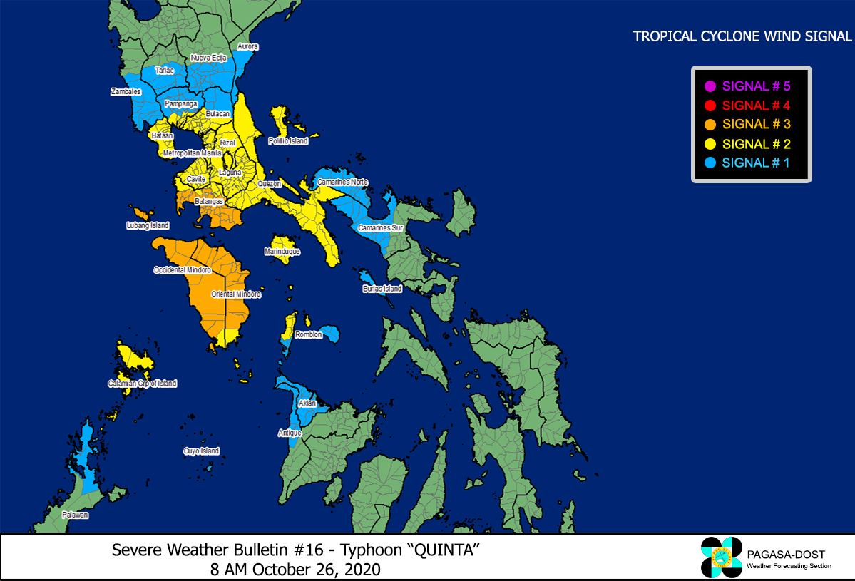
Image Source: DOST-PAGASA (http://pubfiles.pagasa.dost.


