
TROPICAL STORM KABAYAN (JELAWAT) ADVISORY NO. 03Issued at: 9:00 AM PhT (01:00 GMT) Monday, 18 Dec 2023
Next update: 8:00 PM PhT (12:00 GMT) Monday, 18 Dec 2023 |
|
|---|---|
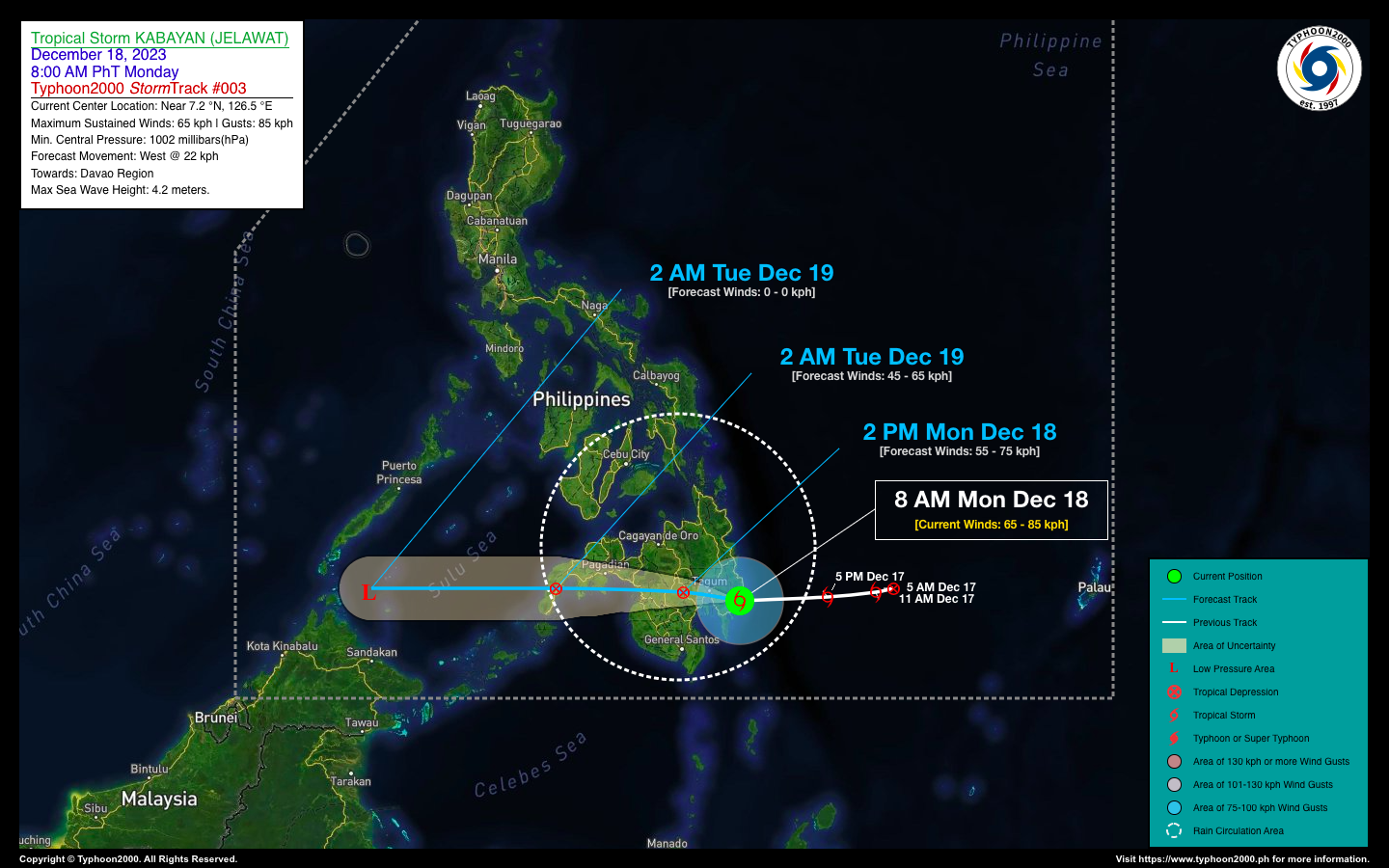
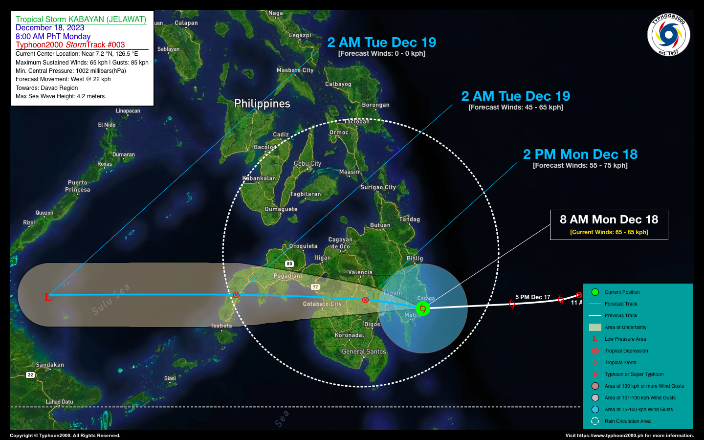
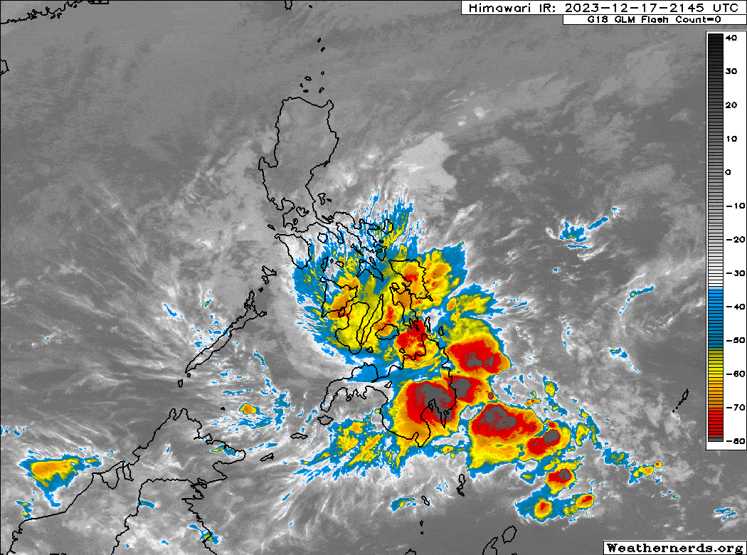
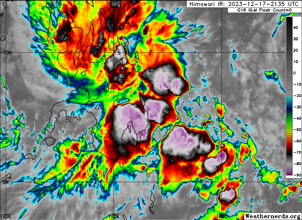
| Current Status & Outlook | Tropical Storm (TS) KABAYAN {JELAWAT} has made landfall over Manay, Davao Oriental as it maintains its strength while tracking westward across Davao Region. Life-threatening Rainfall with gale-force winds of 30-60 kph are expected throughout Davao Region, Caraga, Northern Soccsksargen, & Northern Mindanao today. These rainfall will also extend across Lanao Provinces and Zamboanga Peninsula later today.
24-hr Outlook: TS KABAYAN is forecast to weaken into a Tropical Depression (TD) as it traverses the rugged terrain of Mindanao, and will continue moving westward at 22 kph across Central Mindanao. The center is expected to pass approximately 20 km north of Davao City on or before noon today and will be over Cotabato this afternoon. Later tonight, KABAYAN will emerge over the Moro Gulf, and will be over Zamboanga Sibugay-Zamboanga City by early tomorrow morning (Dec 19). Meanwhile, TS KABAYAN’s circulation will bring moderate to heavy/intense rainfall across Visayas and Mindanao today. It will be more intense along Caraga, Davao Region, Northern Mindanao, Lanao del Sur, Zamboanga Del Norte, Leyte, Bohol, Cebu, Negros, Guimaras, & Southern Panay. Meanwhile, the storm will also enhance the Northeast Monsoon (Amihan) and the Shear Line across Eastern Luzon and the Bicol Region today. Please take all necessary precautions against floods and landslides incl. lahars that will be brought about by these systems. |
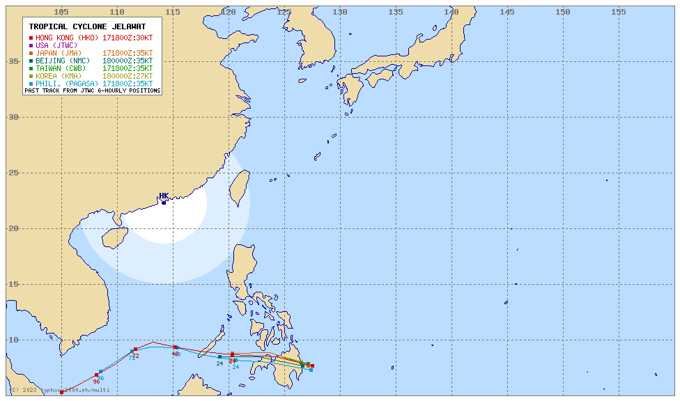
| Where is KABAYAN (JELAWAT)? | As of 8:00 AM PhT today, December 18…0000 GMT:
|
| How strong is it? | Maximum Sustained Winds (1-min avg): 65 kph near the center…Gustiness: 85 kph. |
| Past Movement (06 hrs) | West @ 07 kph, towards Davao Region-Cotabato Area. |
| Potential Philippine Major Landfall Area(s) |
|
| What Philippine areas will be directly affected? | Heavy to Extreme Rainfall (50 mm to >100 mm expected for 24 hrs):
Damaging Winds (gusts of more than 100 km/hr expected):
|
| Potential Storm Surge/Coastal Flooding Areas+ |
+Waves of 3 meters in height are expected in storm surge-prone areas, particularly in coastal areas where the Tropical Cyclone is headed. Kindly visit the PAGASA Storm Surge Updates for more details. |
| 1-Day Forecast Outlook Summary** |
**Important Note: Please be reminded that the Forecast Outlook changes every 6 hours, and the Day 2 and 3 Forecast Track have an average error of 100 and 250 km respectively… while the wind speed forecast error, averages 35 km/hr per day. Therefore, a turn to the left or right of its future track and changes in its wind speed must be anticipated from time to time. |
| Other Storm’s Meteorological Information |
|
| Disclaimer: Information based on data collected by Typhoon2000 (T2k) shall not be taken as official data. Weather information broadcasted and distributed by PAGASA remains as official data. Typhoon2000 (T2k) shall not be responsible for the private use and reliance of its weather information. | |
Issued by: David Michael V. Padua for Typhoon2000 (T2k)
Typhoon2000 (T2K) Integrated Multi-Agency Tracks
For more info visit: (http://www.typhoon2000.ph/multi/?name=JELAWAT)
PAGASA TROPICAL CYCLONE WIND SIGNAL
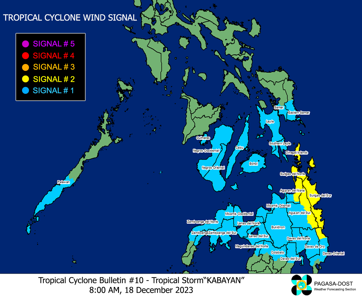
Image/Screenshot Source: DOST-PAGASA (https://bagong.pagasa.dost.gov.ph/tropical-cyclone/severe-weather-bulletin)


