
TYPHOON QUINTA (MOLAVE) ADVISORY NO. 07Issued at: 1:00 AM PhT (17:00 GMT) Monday, 26 October 2020
Next update: 7:00 AM PhT (23:00 GMT) Monday, 26 October 2020 |
|
|---|---|
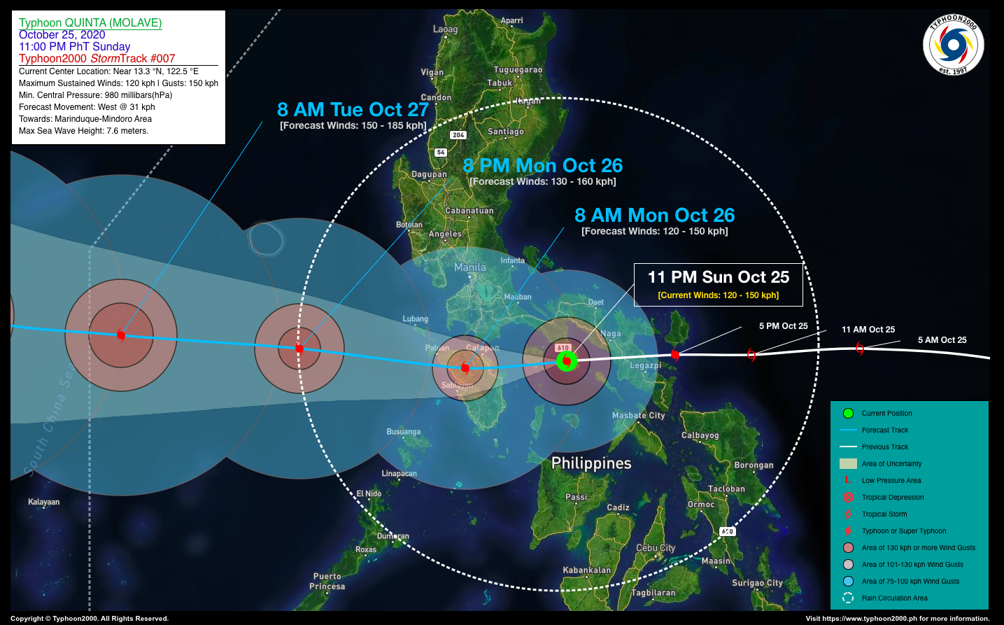
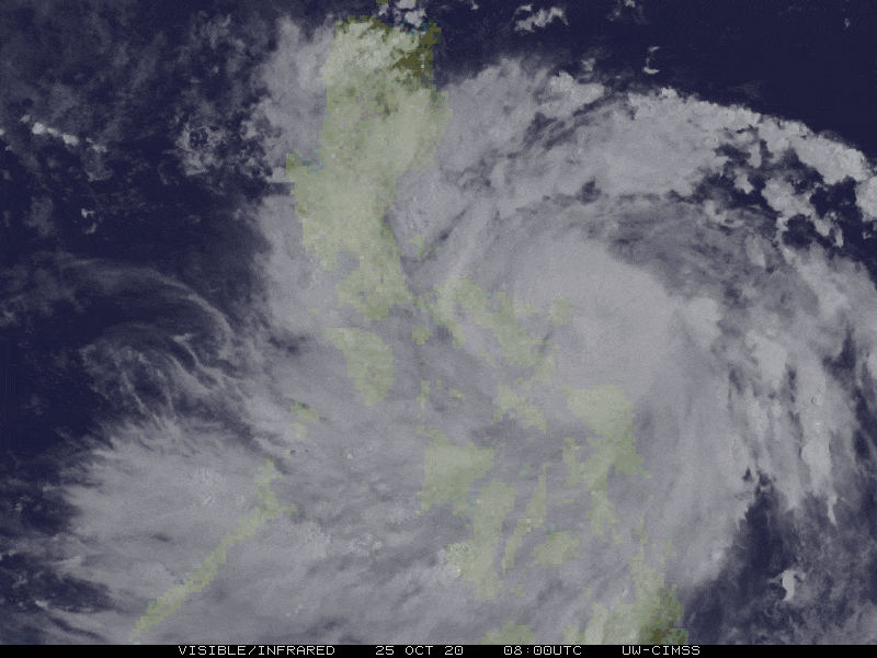
| Current Status and Outlook | The fast-moving Typhoon QUINTA (MOLAVE) has made landfall over Bondoc Peninsula, and weakened slightly after traversing Albay-Camarines Sur Area…now approaching Marinduque. Its inner rainbands continues to affect Bicol Region and Southern Tagalog Provinces including Metro Manila and some portions of Visayas & MiMaRoPa.
24-hr Outlook: TY QUINTA (MOLAVE) is forecast to traverse the Marinduque early this morning, and will make another landfall over Mindoro between 7-8 AM today. It will continue moving westward with a decreased forward speed of 22 km/hr, and shall emerge over the West Philippine Sea in the afternoon through evening. |
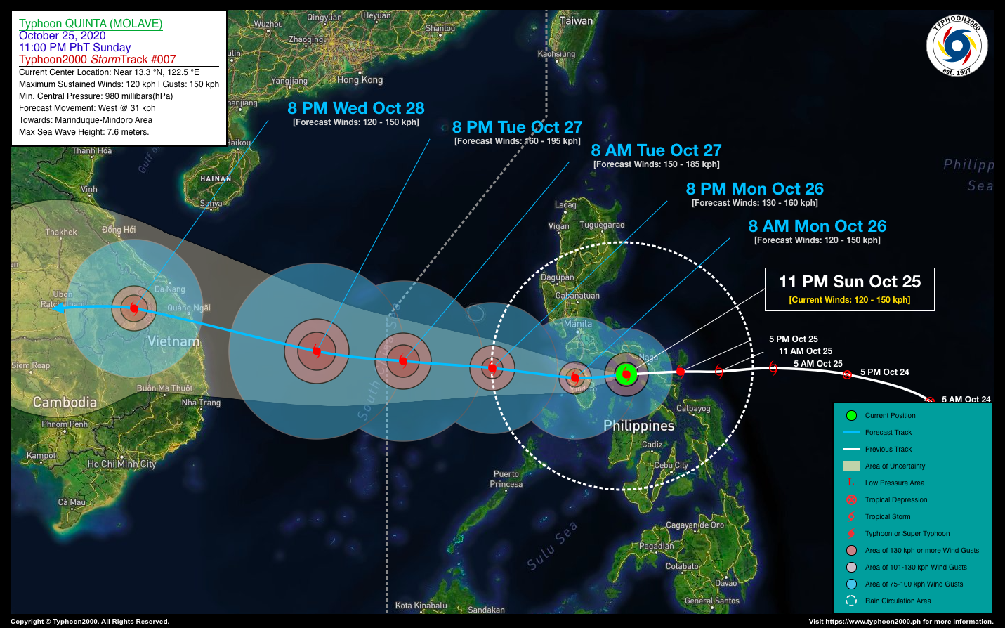
| Where is QUINTA (MOLAVE)? | As of 11:00 PM PhT last night, October 25…1500 GMT. The eye was located over Bondoc Peninsula, Quezon (near 13.3°N 122.5°E), about 24 km west of San Andres, Burias Island or 68 km east of Boac, Marinduque. |
| How strong is it? | Maximum Sustained Winds (1-min avg): 120 kph near the center…Gustiness: 150 kph. |
| Past Movement (06 hrs) | West @ 31 kph, towards Marinduque-Mindoro Area |
| Potential Philippine Landfall Area(s) | :: Landfall 3: Over Marinduque, between 12-1 AM today – with High Strike Probability of 100%.
:: Landfall 4: Over Northern Mindoro, between 6-7 AM today – with High Strike Probability of 90%. |
| What Philippine areas will be directly affected? | Heavy to Extreme Rains (50 mm to >100 mm expected in 24 hrs): >> Bicol Region, CaLaBaRZon, Mindoro, Marinduque, Romblon – tonight until tomorrow, Monday afternoon (Oct 26). Damaging Winds (gusts of more than 100 km/hr expected): |
| Potential Storm Surge/Coastal Flooding Areas+ | :: Coastal Areas of Bicol Region, Masbate, Ticao-Burias Islands, Bondoc Peninsula, MiMaRoPa, CaLaBaRZon – Today.
+Waves of 3 meters in height is expected in storm surge-prone areas, particularly in coastal areas on where the Tropical Cyclone is headed. Kindly visit the PAGASA Storm Surge Updates for more details. |
| 2-Day Forecast Outlook Summary** | MONDAY EVENING: Over the West Philippine Sea…turns WNW and intensifies…about 263 km NW of Coron, Palawan [8PM Oct 26: 13.5°N 118.3°E @ 130 kph]. Confidence Level: MEDIUM
TUESDAY EVENING: Already outside of the Philippine Area of Responsibility (PAR)…intensifies further into Category 2 as it approaches Vietnam…about 790 km NW of Puerto Princesa City, Palawan [8PM Oct 27: 14.0°N 112.8°E @ 160 kph]. Confidence Level: MEDIUM **Important Note: Please be reminded that the Forecast Outlook changes every 6 hours, and the Day 2 and 3 Forecast Track have an average error of 100 and 250 km respectively… while the wind speed forecast error, averages 35 km/hr per day. Therefore, a turn to the left or right of its future track and changes in its wind speed must be anticipated from time to time. |
| Other Storm’s Meteorological Info | > 24 hr. Rain Accumulation (across its circulation): 25 to 320 mm [Light to Intense]
> Minimum Central Pressure: 980 millibars (hPa) > Size of Circulation [Convective Cloud-Based, in diameter]: 430 km (Small) > Area of Damaging Winds (100 kph or more wind gusts): 75 km from the center. |
| Current Summary/Additional Reference Points | Time/Date: 11:00 PM PhT Sun October 25, 2020 Location of Center/Eye: Near 13.3°N Lat 122.5°E Lon Distance 1: 67 km SSW of Ragay, Camarines Sur Distance 2: 83 km WSW of Naga City, Camarines Sur Distance 3: 91 km W of Nabua, Camarines Sur Distance 4: 100 km W of Iriga City, Camarines Sur Distance 5: 210 km SE of Metro Manila |
| Information based on data collected by Typhoon2000 (T2k) shall not be taken as official data. Weather information broadcasted and distributed by PAGASA remains as official data. Typhoon2000 (T2k) shall not be responsible for the private use and reliance of its weather information. | |
Issued by: David Michael V. Padua for Typhoon2000 (T2K)
PAGASA TROPICAL CYCLONE WIND SIGNAL
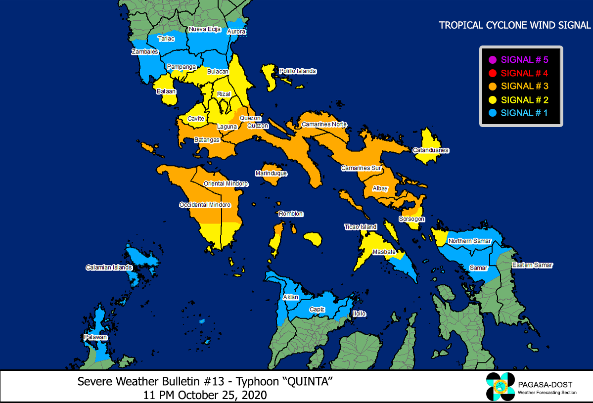
Image Source: DOST-PAGASA (http://pubfiles.pagasa.dost.


