

SEVERE TROPICAL STORM QUINTA (MOLAVE) ADVISORY NO. 05Issued at: 1:00 PM PhT (05:00 GMT) Sunday, 25 October 2020
Next update: 7:00 PM PhT (11:00 GMT) Sunday, 25 October 2020 |
|
|---|---|
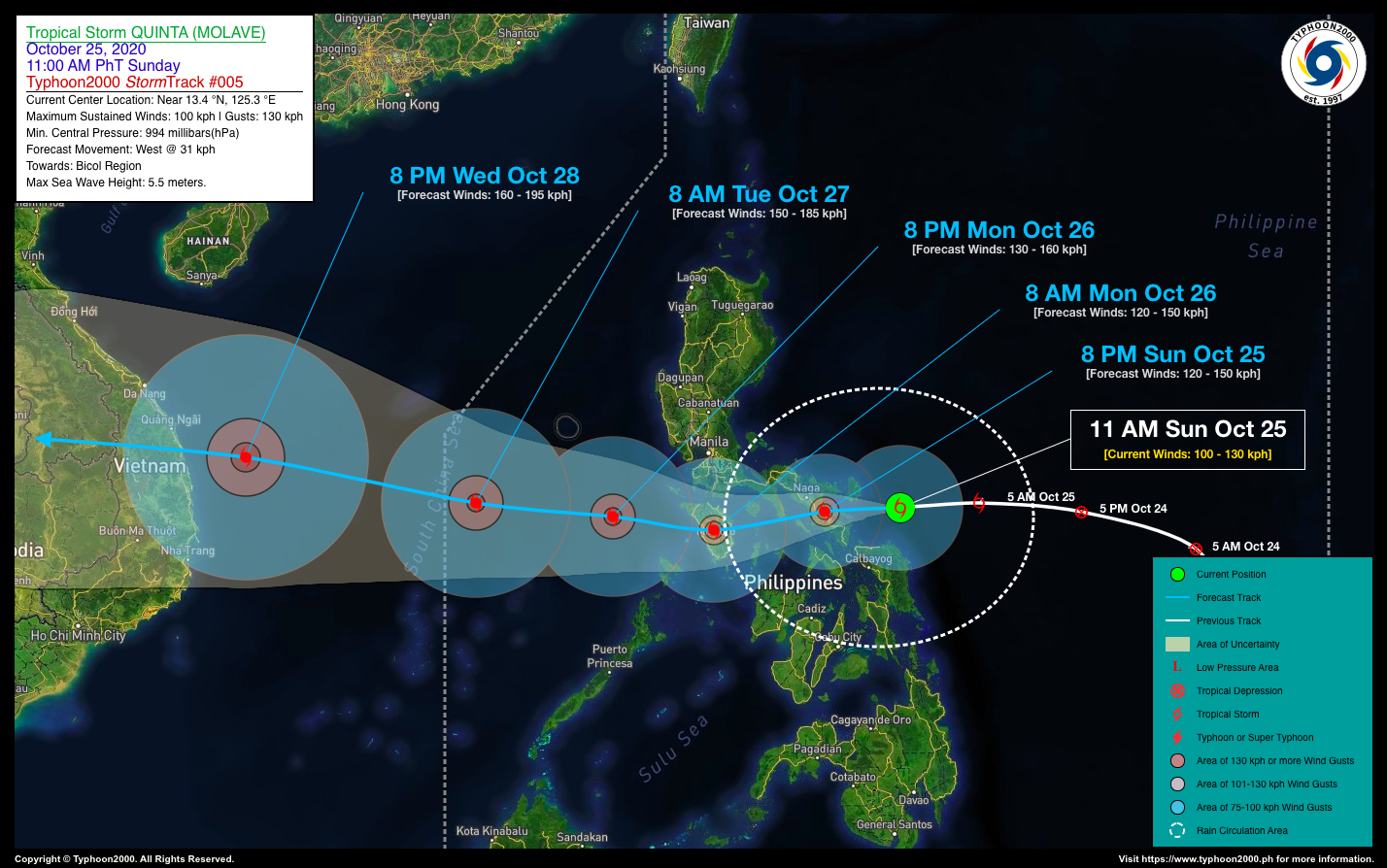
| Current Status and Outlook | QUINTA (MOLAVE) has rapidly grown into a 100-km/hr Severe Tropical Storm (STS) as it races quickly towards the west…endangering Bicol Region & Northern Samar…likely to become a Category 1 Typhoon (TY) on or before it makes landfall over Catanduanes-Albay-Sorsogon Area this afternoon and early evening.
24-hr Outlook: STS QUINTA (MOLAVE) is forecast to gain more strength upon traversing the Bicol Peninsula late this afternoon and evening, and will continue moving westward @ 22-24 km/hr. The center is expected to traverse Southern Camarines Sur-Northern Albay Area tonight, emerging over the Sibuyan Sea-Bondoc Peninsula Area by midnight. It shall be making landfall over Mindoro on or before sunrise tomorrow (Oct 26) and be in the vicinity of Central Mindoro at 8AM tomorrow. |
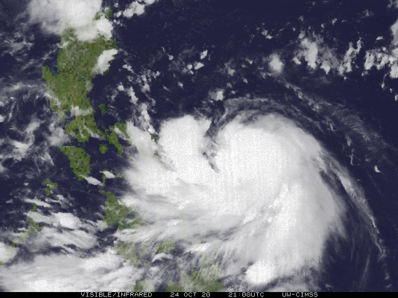
| Where is QUINTA (MOLAVE)? | As of 11:00 AM PhT today, October 25…0300 GMT. The center was located along the mid-western portion of the Central Philippine Sea (near 13.4°N 125.4°E), about 128 km east of Virac, Catanduanes or 234 km east of Naga City, Camarines Sur. |
| How strong is it? | Maximum Sustained Winds (1-min avg): 100 kph near the center…Gustiness: 130 kph. |
| Past Movement (06 hrs) | West @ 31 kph, towards the Bicol Region |
| Potential Philippine Landfall Area(s) | :: Landfall 1: Along Rapu-Rapu Island-Bacacay-Tabaco Area (Albay), between 6-8 PM Tonight – with High Strike Probability of 90%.
:: Landfall 2: Over Northern Burias or Southern Bondoc Peninsula (Quezon), between 12-1 AM Tomorrow, Monday Morning – with High Strike Probability of 85%. |
| What Philippine areas will be directly affected? | Heavy to Extreme Rains (50 mm to >100 mm expected in 24 hrs): >> Bicol Region, Eastern & Northern Samar – beginning today until tomorrow, Monday morning (Oct 26).>> Calabarzon, Mindoro, Marinduque, Romblon – beginning tonight until tomorrow, Monday afternoon (Oct 26). Damaging Winds (gusts of more than 100 km/hr expected): |
| Potential Storm Surge/Coastal Flooding Areas+ | :: Coastal Areas of Bicol Region & Northern Samar – Today.
+Waves of 3 meters in height is expected in storm surge-prone areas, particularly in coastal areas on where the Tropical Cyclone is headed. Kindly visit the PAGASA Storm Surge Updates for more details. |
| 3-Day Forecast Outlook Summary** | MONDAY MORNING: Over Central Mindoro…maintains its typhoon classification as it turns WSW to Westward…about 54 km S of Calapan City, Oriental Mindoro [8AM Oct 26: 12.9°N 121.1°E @ 120 kph]. Confidence Level: HIGH
TUESDAY MORNING: Emerges over the West Philippine Sea and is about to exit the Philippine Area of Responsibility (PAR) – after traversing Mindoro…intensifies further as it moves WNW…about 512 km WNW of Coron, Palawan [8AM Oct 27: 13.5°N 115.7°E @ 150 kph]. Confidence Level: MEDIUM WEDNESDAY MORNING: Already outside of PAR as it becomes a Category 2 Typhoon (TY)…approaching Vietnam…about 957 km SSW of Hong Kong, China [8AM Oct 28: 14.5°N 110.5°E @ 160 kph]. Confidence Level: MEDIUM **Important Note: Please be reminded that the Forecast Outlook changes every 6 hours, and the Day 2 and 3 Forecast Track have an average error of 100 and 250 km respectively… while the wind speed forecast error, averages 35 km/hr per day. Therefore, a turn to the left or right of its future track and changes in its wind speed must be anticipated from time to time. |
| Other Storm’s Meteorological Info | > 24 hr. Rain Accumulation (across its circulation): 25 to 300 mm [Light to Heavy]
> Minimum Central Pressure: 994 millibars (hPa) > Size of Circulation [Convective Cloud-Based, in diameter]: 540 km (Small) > Area of Damaging Winds (100 kph or more wind gusts): 35 km from the center. |
| Current Summary/Additional Reference Points | Time/Date: 11:00 AM PhT Sun October 25, 2020 Location of Center/Eye: Near 13.4°N Lat 125.4°E Lon Distance 1: 162 km ENE of Sorsogon City, Sorsogon Distance 2: 183 km E of Legazpi City, Albay Distance 3: 217 km E of Iriga City, Camarines Sur Distance 4: 272 km ESE of Daet, Camarines Norte Distance 5: 486 km ESE of Metro Manila |
| Information based on data collected by Typhoon2000 (T2k) shall not be taken as official data. Weather information broadcasted and distributed by PAGASA remains as official data. Typhoon2000 (T2k) shall not be responsible for the private use and reliance of its weather information. | |
Issued by: David Michael V. Padua for Typhoon2000 (T2K)
PAGASA TROPICAL CYCLONE WIND SIGNAL
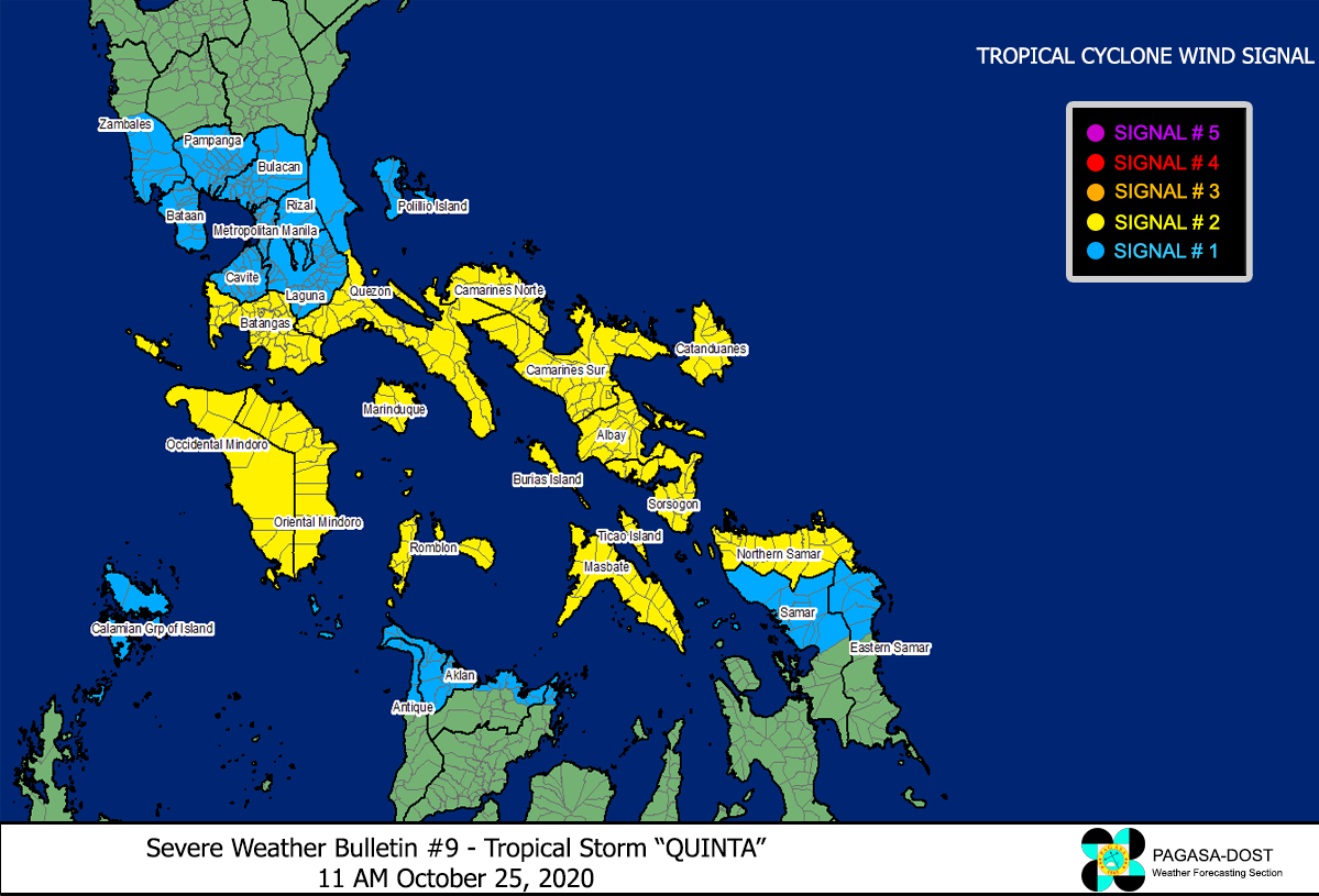
Image Source: DOST-PAGASA (http://pubfiles.pagasa.dost.


