
TROPICAL STORM PEPITO (SAUDEL) ADVISORY NO. 09Issued at: 1:00 PM PhT (05:00 GMT) Wednesday, 21 October 2020
Next update: 7:00 PM PhT (11:00 GMT) Wednesday, 21 October 2020 |
|
|---|---|
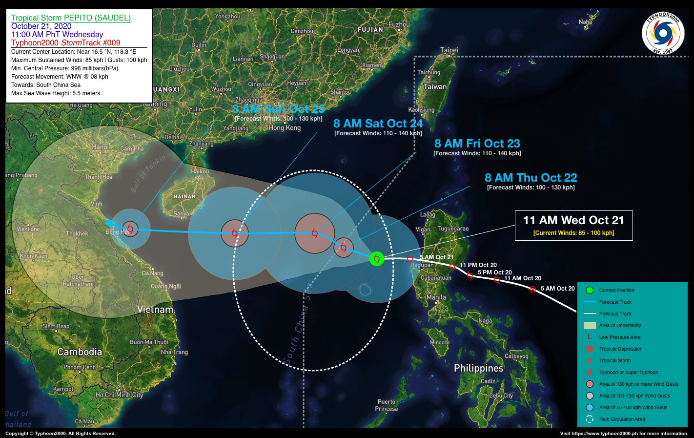
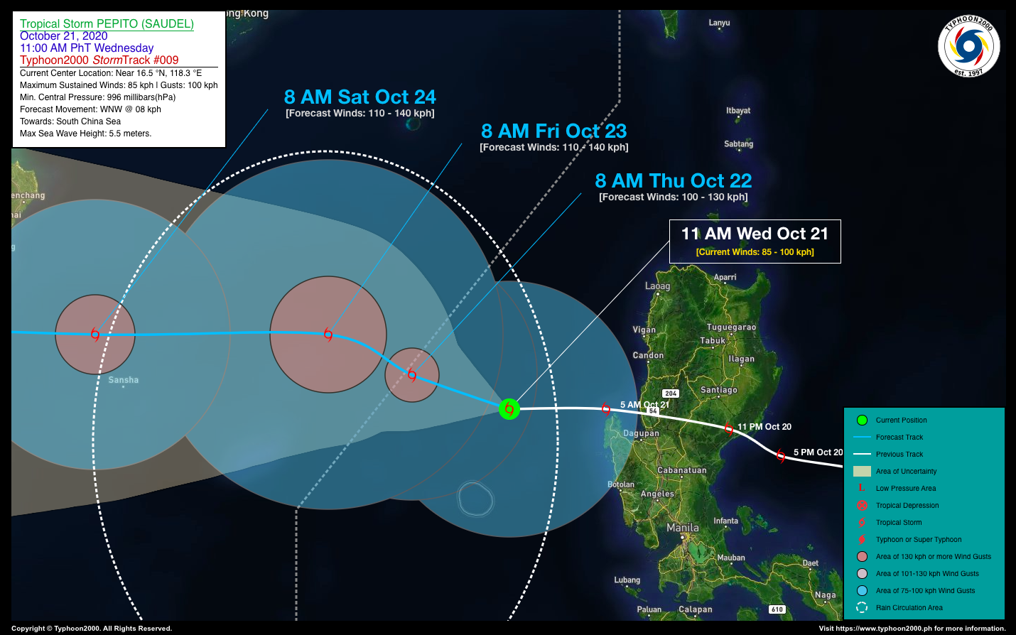
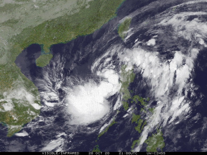
| Current Status and Outlook | Tropical Storm PEPITO (SAUDEL) continues to move westward, away from Luzon as it re-intensifies over the West Philippine Sea…expected to exit the western border of the Philippine Area of Responsibility (PAR) tomorrow morning (Oct 22).
24-hr Outlook: TS PEPITO (SAUDEL) will rapidly slow down for the next 12 to 24 hours and could become a Severe Tropical Storm (STS) by later today. The combination of Pepito’s Rainbands, its Trough and the Enhanced Southwesterly Surface Windflow – will bring overcast skies with isolated to scattered rain showers and thunderstorms across Western Luzon and MiMaRoPa today. |
| Where is PEPITO (SAUDEL)? | As of 11:00 AM PhT Today, October 21…0300 GMT. The center was located over the West Philippine Sea, just north of Scarborough (Panatag) Shoal (near 16.5°N 118.3°E), about 184 km west-northwest of Alaminos City, Pangasinan or 223 km west-northwest of Dagupan City, Pangasinan. |
| How strong is it? | Maximum Sustained Winds (1-min avg): 85 kph near the center…Gustiness: 100 kph. |
| Past Movement (06 hrs) | West @ 27 kph, towards the South China Sea. |
| Potential Philippine Landfall Area(s) | :: None |
| What Philippine areas will be directly affected? | Heavy to Extreme Rains (50 mm to >100 mm expected in 24 hrs): >> None. Damaging Winds (gusts of more than 100 km/hr expected): |
| Potential Storm Surge/Coastal Flooding Areas+ | :: None.
+Waves of 3 meters in height is expected in storm surge-prone areas, particularly in coastal areas on where the Tropical Cyclone is headed. Kindly visit the PAGASA Storm Surge Updates for more details. |
| 3-Day Forecast Outlook Summary** | THURSDAY MORNING: Strengthens into a Severe Tropical Storm (STS) as it moves slowly, WNW…exits the western border of PAR…about 352 km WNW of Alaminos City, Pangasinan [8AM Oct 22: 17.0°N 116.8°E @ 100 kph]. Confidence Level: HIGH
FRIDAY MORNING: Continues to intensify while over the South China Sea on a slow, westerly track…about 504 km WNW of Alaminos City, Pangasinan [8AM Oct 23: 17.6°N 115.5°E @ 110 kph]. Confidence Level: LOW SATURDAY MORNING: Maintains its strengthens as accelerates westward towards Hainan-Northern Vietnam Area…about 581 km SSW of Hong Kong, China [8AM Oct 24: 17.6°N 111.9°E @ 110 kph]. Confidence Level: LOW **Important Note: Please be reminded that the Forecast Outlook changes every 6 hours, and the Day 2 and 3 Forecast Track have an average error of 100 and 250 km respectively… while the wind speed forecast error, averages 35 km/hr per day. Therefore, a turn to the left or right of its future track and changes in its wind speed must be anticipated from time to time. |
| Other Storm’s Meteorological Info | > 24 hr. Rain Accumulation (across its circulation): 25 to 220 mm [Light to Heavy]
> Minimum Central Pressure: 996 millibars (hPa) > Size of Circulation [Convective Cloud-Based, in diameter]: 735 km (Medium) > Area of Damaging Winds (100 kph or more wind gusts): None. |
| Current Summary/Additional Reference Points | Time/Date: 11:00 AM PhT Wed October 21, 2020 Location of Center/Eye: Near 16.5°N Lat 118.3°E Lon Distance 1: 245 km W of Baguio City, Benguet Distance 2: 252 km WSW of Vigan City, Ilocos Sur Distance 3: 282 km WNW of Mabalacat City, Pampanga Distance 4: 287 km WNW of Angeles City, Pampanga Distance 5: 365 km NW of Metro Manila |
| Information based on data collected by Typhoon2000 (T2k) shall not be taken as official data. Weather information broadcasted and distributed by PAGASA remains as official data. Typhoon2000 (T2k) shall not be responsible for the private use and reliance of its weather information. | |
Issued by: David Michael V. Padua for Typhoon2000 (T2K)
PAGASA TROPICAL CYCLONE WIND SIGNALS

Screenshot/Image Source: DOST-PAGASA (http://pubfiles.pagasa.dost.


