

TROPICAL STORM PEPITO (SAUDEL) ADVISORY NO. 08Issued at: 7:00 AM PhT (23:00 GMT) Wednesday, 21 October 2020
Next update: 1:00 PM PhT (05:00 GMT) Wednesday, 21 October 2020 |
|
|---|---|
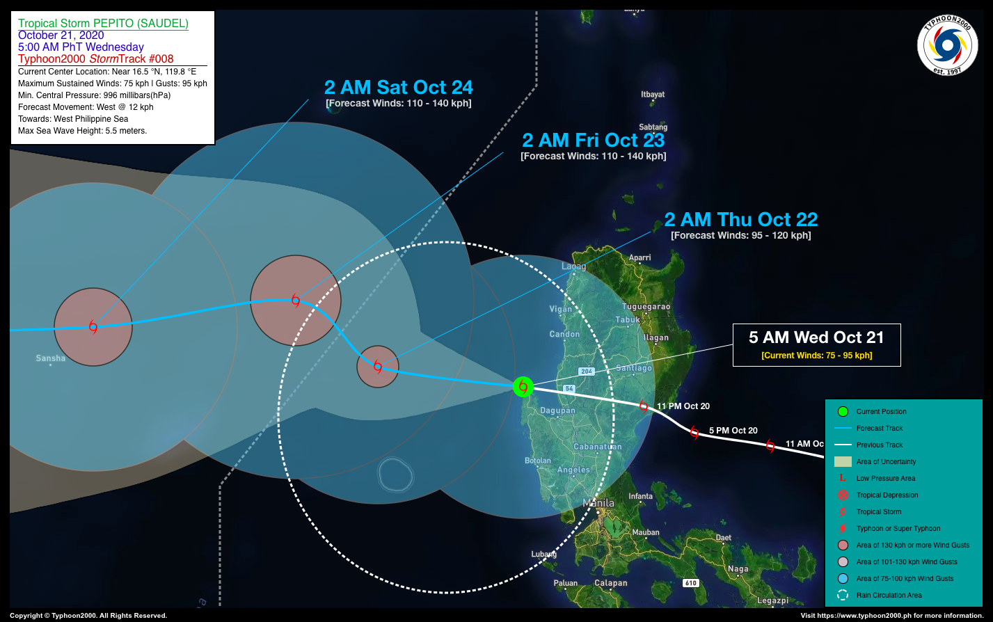
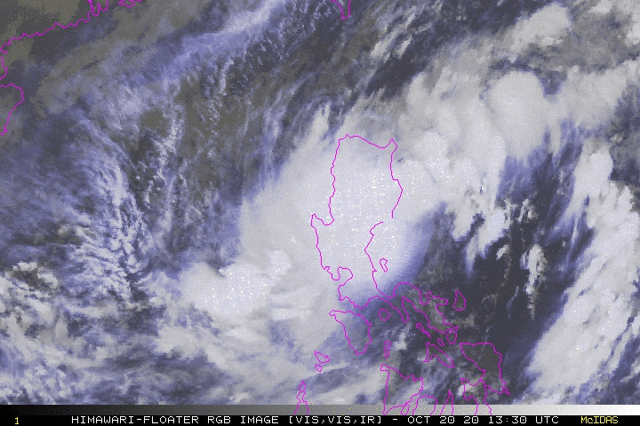
| Current Status and Outlook | Tropical Storm PEPITO (SAUDEL) weakens slightly after crossing the southern portion of Northern Luzon during the past 8 hours…now in the vicinity of Cape Bolinao (Pangasinan) as it swiftly moves westerly towards the West Philippine Sea.
24-hr Outlook: TS PEPITO (SAUDEL) will rapidly slow down for the next 12 to 24 hours as it re-organizes over the West Philippine Sea, and could become a Severe Tropical Storm (STS) by early tomorrow morning (Oct 22). It shall move out of the Philippine Area of Responsibility (PAR) around 8 AM tomorrow. The combination of Pepito’s Rainbands, its Trough and the Enhanced Southwesterly Surface Windflow – will bring overcast skies with isolated to scattered rain showers and thunderstorms across Luzon and Visayas including MiMaRoPa, Sulu Archipelago, and Western Mindanao today. |
| Where is PEPITO (SAUDEL)? | As of 5:00 AM PhT Today, October 21…2100 GMT. The center was located along the coastal waters of Cape Bolinao, Pangasinan (near 16.5°N 119.8°E), about 44 km north-northwest of Alaminos City, Pangasinan or 76 km northwest of Dagupan City, Pangasinan. |
| How strong is it? | Maximum Sustained Winds (1-min avg): 75 kph near the center…Gustiness: 95 kph. |
| Past Movement (06 hrs) | West @ 34 kph, towards the West Philippine Sea. |
| Potential Philippine Landfall Area(s) | :: None |
| What Philippine areas will be directly affected? | Heavy to Extreme Rains (50 mm to >100 mm expected in 24 hrs): >> None. Damaging Winds (gusts of more than 100 km/hr expected): |
| Potential Storm Surge/Coastal Flooding Areas+ | :: None.
+Waves of 3 meters in height is expected in storm surge-prone areas, particularly in coastal areas on where the Tropical Cyclone is headed. Kindly visit the PAGASA Storm Surge Updates for more details. |
| 3-Day Forecast Outlook Summary** | THURSDAY EARLY MORNING: Strengthens into a Severe Tropical Storm (STS) as it moves WNW…about to exit the western border of PAR…about 275 km WNW of Alaminos City, Pangasinan [2AM Oct 22: 16.8°N 117.5°E @ 95 kph]. Confidence Level: MEDIUM
FRIDAY EARLY MORNING: Turns NW-ward slowly after exiting the western border of PAR, intensifies further while over the South China Sea…about 442 km WNW of Alaminos City, Pangasinan [2AM Oct 23: 17.8°N 116.2°E @ 110 kph]. Confidence Level: LOW SATURDAY EARLY MORNING: Maintains its strengthens as it resumes its westerly track towards Hainan-Northern Vietnam Area…about 568 km SSW of Hong Kong, China [2AM Oct 24: 17.4°N 113.0°E @ 110 kph]. Confidence Level: LOW **Important Note: Please be reminded that the Forecast Outlook changes every 6 hours, and the Day 2 and 3 Forecast Track have an average error of 100 and 250 km respectively… while the wind speed forecast error, averages 35 km/hr per day. Therefore, a turn to the left or right of its future track and changes in its wind speed must be anticipated from time to time. |
| Other Storm’s Meteorological Info | > 24 hr. Rain Accumulation (across its circulation): 25 to 200 mm [Light to Heavy]
> Minimum Central Pressure: 996 millibars (hPa) > Size of Circulation [Convective Cloud-Based, in diameter]: 825 km (Medium) > Area of Damaging Winds (100 kph or more wind gusts): None. |
| Current Summary/Additional Reference Points | Time/Date: 5:00 AM PhT Wed October 21, 2020 Location of Center/Eye: Near 16.5°N Lat 119.8°E Lon Distance 1: 87 km NW of San Carlos City, Pangasinan Distance 2: 134 km SSW of Vigan City, Ilocos Sur Distance 3: 150 km WNW of San Jose City, Nueva Ecija Distance 4: 169 km NW of Cabanatuan City, Nueva Ecija Distance 5: 253 km NNW of Metro Manila |
| Information based on data collected by Typhoon2000 (T2k) shall not be taken as official data. Weather information broadcasted and distributed by PAGASA remains as official data. Typhoon2000 (T2k) shall not be responsible for the private use and reliance of its weather information. | |
Issued by: David Michael V. Padua for Typhoon2000 (T2K)
PAGASA TROPICAL CYCLONE WIND SIGNALS


Screenshot/Image Source: DOST-PAGASA (http://pubfiles.pagasa.dost.


