

TROPICAL STORM PEPITO (SAUDEL) ADVISORY NO. 07Issued at: 1:00 AM PhT (17:00 GMT) Wednesday, 21 October 2020
Next update: 7:00 AM PhT (23:00 GMT) Wednesday, 21 October 2020 |
|
|---|---|
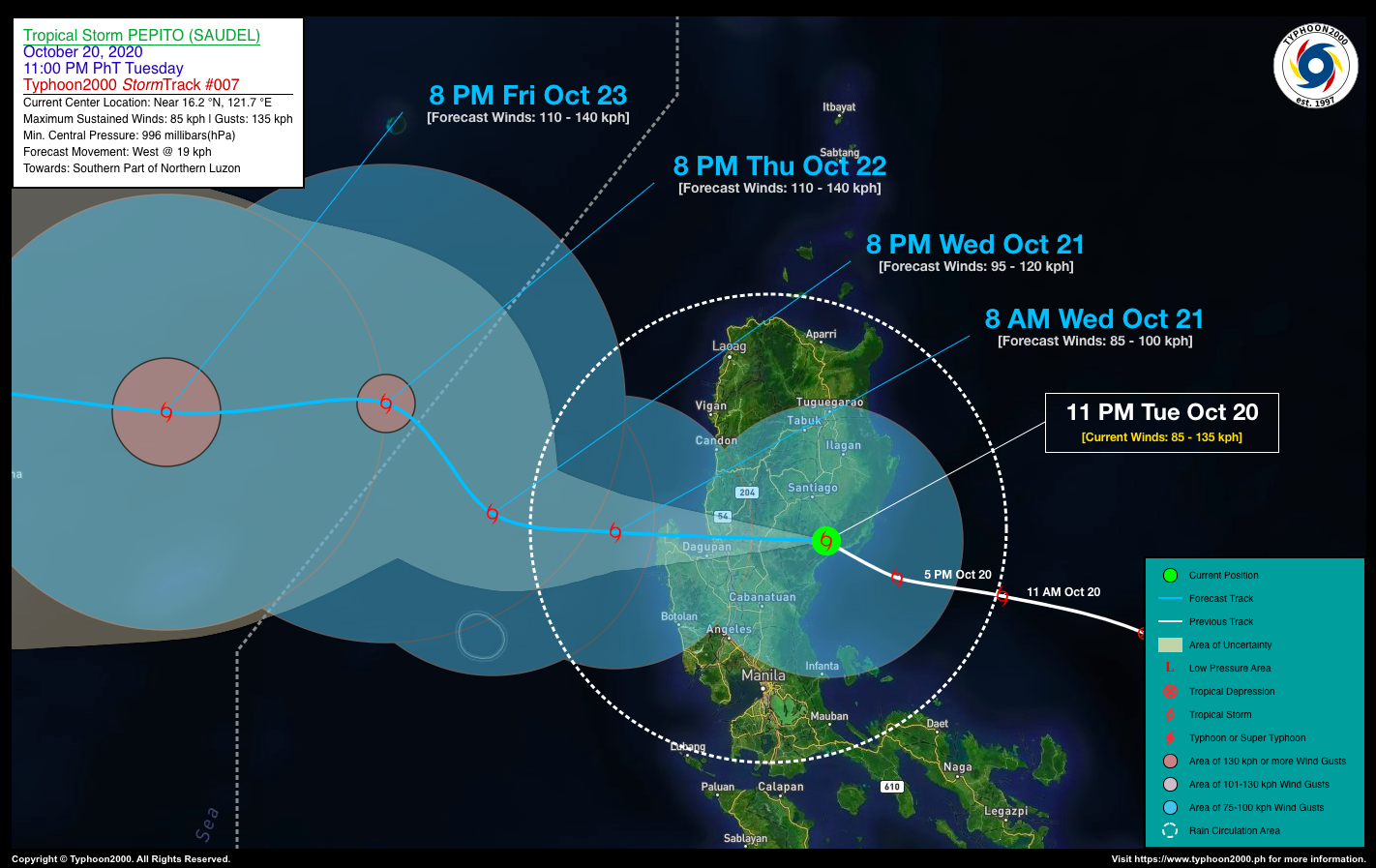
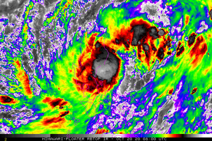
| Current Status and Outlook | Tropical Storm PEPITO (SAUDEL) has made landfall along the San Idelfonso Peninsula in Casiguran, Aurora around 9:00 PM last night…now traversing Quirino and Nueva Vizcaya Area. Its rainbands continues to bring occasional rains and gusty winds across Northern & Central Luzon.
24-hr Outlook: TS PEPITO (SAUDEL) will slightly weaken as it continues to traverse the southern portion of the Cordillera Mountain Range early this morning – passing across the provinces of Benguet, Pangasinan, & La Union. Then later this morning, the storm will be emerging over the West Philippine Sea, tracking westward at 19 kph and intensifying into a Severe Tropical Storm (STS) tonight. The combination of Pepito’s Rainbands, its Trough and the Enhanced Northeasterly & Southwesterly Surface Windflows will bring overcast skies with scattered to widespread “on-&-off” rain showers and thunderstorms across Luzon and Visayas including MiMaRoPa, Sulu Archipelago, and Western Mindanao today. |
| Where is PEPITO (SAUDEL)? | As of 11:00 PM PhT last night, October 20…1500 GMT. The center was located in the vicinity of Nagtipunan, Quirino (near 16.2°N 121.7°E), about 39 km west of Casiguran, Aurora or 120 km east of Baguio City, Benguet. |
| How strong is it? | Maximum Sustained Winds (1-min avg): 85 kph near the center…Gustiness: 135 kph. |
| Past Movement (06 hrs) | West-Northwest @ 16 kph, across the Southern Part of Northern Luzon. |
| Potential Philippine Landfall Area(s) | :: None |
| What Philippine areas will be directly affected? | Heavy to Extreme Rains (50 mm to >100 mm expected in 24 hrs): >> Most Parts of Northern & Central Luzon – Today. Damaging Winds (gusts of more than 100 km/hr expected): |
| Potential Storm Surge/Coastal Flooding Areas+ | :: None.
+Waves of 3 meters in height is expected in storm surge-prone areas, particularly in coastal areas on where the Tropical Cyclone is headed. Kindly visit the PAGASA Storm Surge Updates for more details. |
| 3-Day Forecast Outlook Summary** | WEDNESDAY EVENING: Emerges over the West Philippine Sea, just north of Scarborough (Panatag) Shoal while intensifying into an STS…about 226 km W of Alaminos City, Pangasinan [8PM Oct 21: 16.5°N 117.9°E @ 95 kph]. Confidence Level: MEDIUM
THURSDAY EVENING: Turns NW-ward slowly and exits the western border of the Philippine Area of Responsibility (PAR), intensifies further while over the South China Sea…about 390 km WNW of Alaminos City, Pangasinan [8PM Oct 22: 17.7°N 116.7°E @ 110 kph]. Confidence Level: LOW FRIDAY EVENING: Maintains its strengthens as it resumes its westerly track towards Hainan-Northern Vietnam Area…about 533 km S of Hong Kong, China [8PM Oct 23: 17.6°N 114.2°E @ 110 kph]. Confidence Level: LOW **Important Note: Please be reminded that the Forecast Outlook changes every 6 hours, and the Day 2 and 3 Forecast Track have an average error of 100 and 250 km respectively… while the wind speed forecast error, averages 35 km/hr per day. Therefore, a turn to the left or right of its future track and changes in its wind speed must be anticipated from time to time. |
| Other Storm’s Meteorological Info | > 24 hr. Rain Accumulation (across its circulation): 25 to 200 mm [Light to Heavy]
> Minimum Central Pressure: 996 millibars (hPa) > Size of Circulation [Convective Cloud-Based, in diameter]: 810 km (Medium) > Area of Damaging Winds (100 kph or more wind gusts): None. |
| Current Summary/Additional Reference Points | Time/Date: 11:00 PM PhT Tue October 20, 2020 Location of Center/Eye: Near 16.2°N Lat 121.7°E Lon Distance 1: 59 km SSE of Santiago City, Isabela Distance 2: 87 km ENE of San Jose City, Nueva Ecija Distance 3: 108 km SSW of Ilagan City, Isabela Distance 4: 123 km ENE of Urdaneta City, Pangasinan Distance 5: 193 km NNE of Metro Manila 24 hr. Forecast Coordinates (Class): 16.5°N 117.9°E (STS) 48 hr. Forecast Coordinates (Class): 17.7°N 116.7°E (STS) 72 hr. Forecast Coordinates (Class): 17.6°N 114.2°E (STS) |
| Information based on data collected by Typhoon2000 (T2k) shall not be taken as official data. Weather information broadcasted and distributed by PAGASA remains as official data. Typhoon2000 (T2k) shall not be responsible for the private use and reliance of its weather information. | |
Issued by: David Michael V. Padua for Typhoon2000 (T2K)
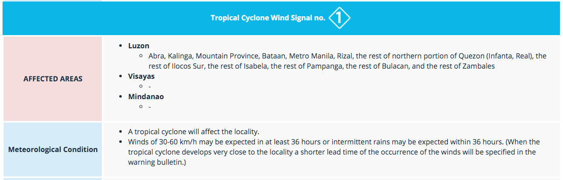
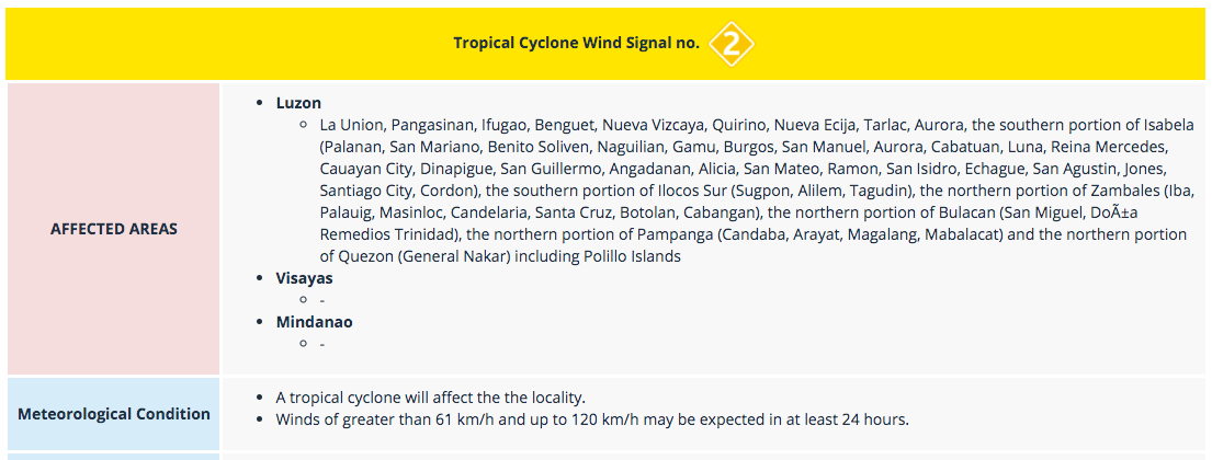
PAGASA TROPICAL CYCLONE WIND SIGNAL
Screenshot/Image Source: DOST-PAGASA (http://pubfiles.pagasa.dost.


