


SEVERE TROPICAL STORM FLORITA (MA-ON) ADVISORY NO. 09 [Final]Issued at: 2:00 PM PhT (06:00 GMT) Wednesday, 24 August 2022
|
|
|---|---|
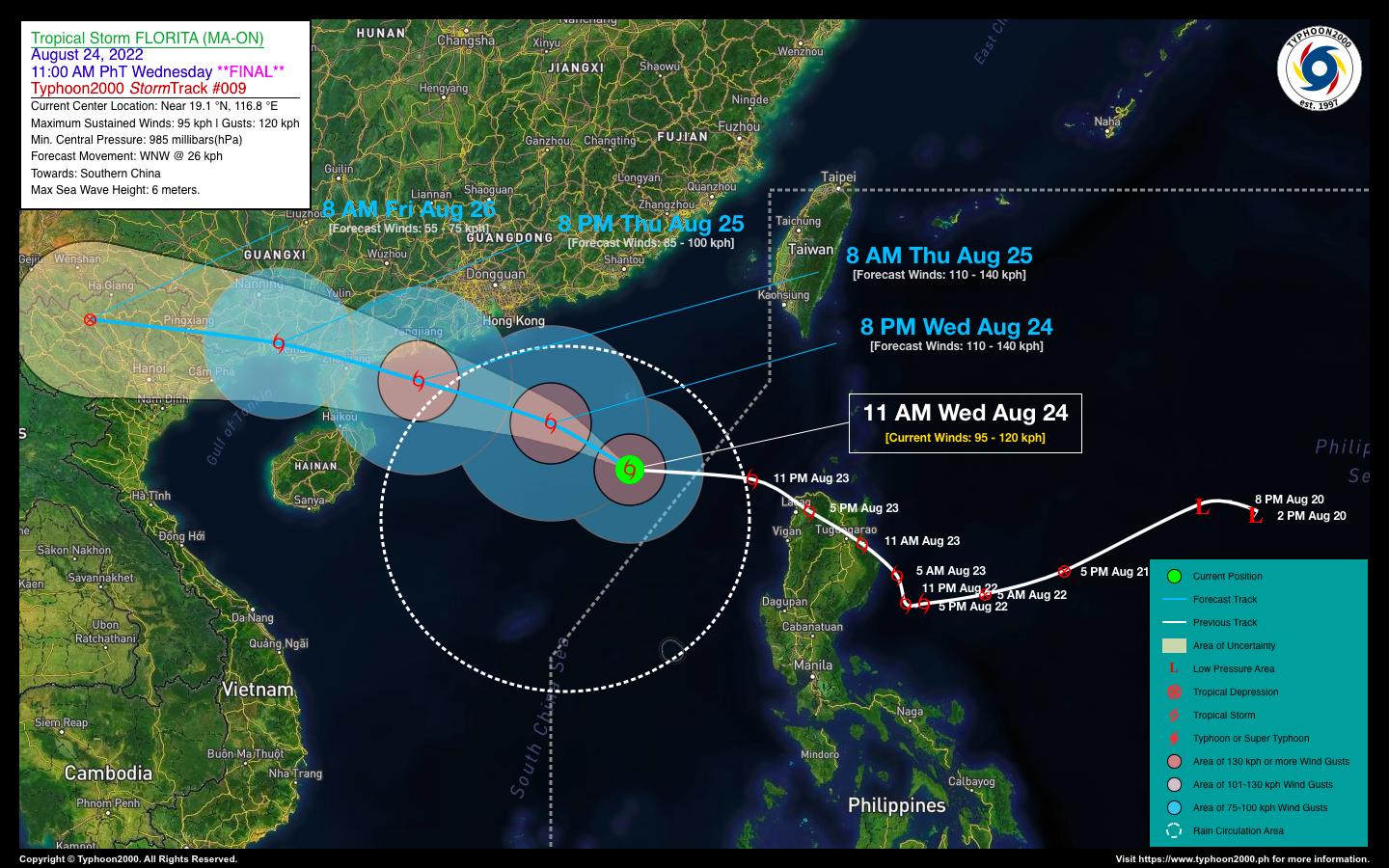
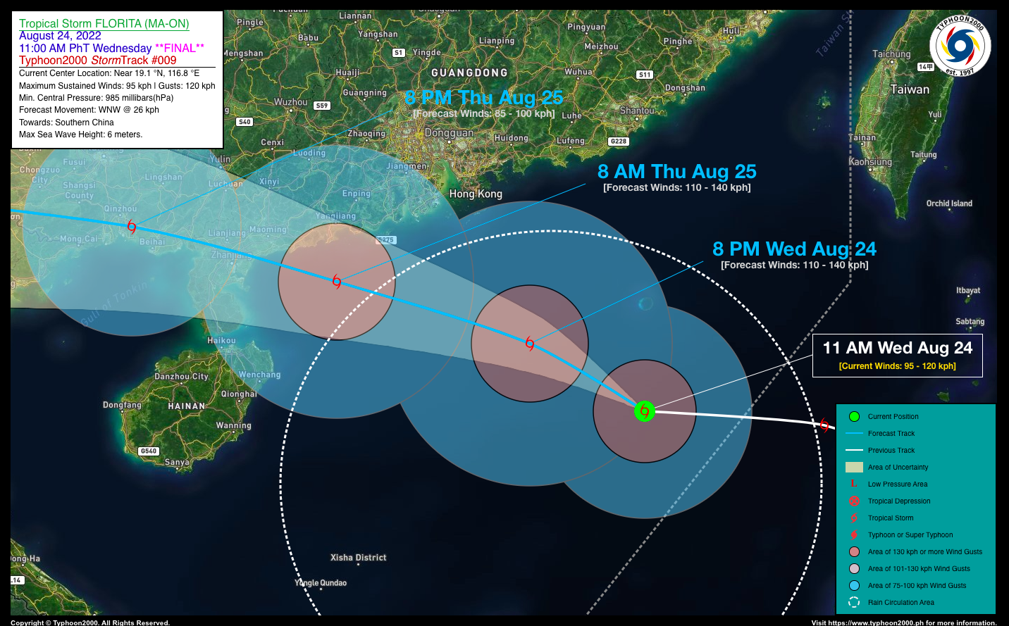
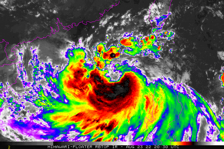
| Current Status & Outlook | Severe Tropical Storm FLORITA (MA-ON) has moved out of the Philippine Area of Responsibility while maintaining its strength and threat to Southern China.
*This is the Final Advisory on this Tropical Cyclone. 24-hr Outlook: STS FLORITA (MA-ON) is no longer forecast to reach Typhoon classification due to deteriorating upper-level environment. It is now expected to make landfall in the vicinity of Leizhou Peninsula (Southern China) on Thursday afternoon with estimated wind speeds of 110 km/hr. Its forward motion is forecast to increase back to 26 km/hr on a WNW track. Meanwhile, the enhanced Southwest Monsoon (Habagat) has diminished in strength. Improving weather conditions will be expected across Western Philippines. |
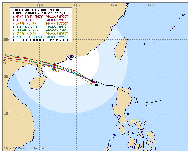
| Where is FLORITA (MA-ON)? | As of 11:00 AM PhT today, August 24…0300 GMT:
|
| How strong is it? | Maximum Sustained Winds (1-min avg): 95 kph near the center…Gustiness: 120 kph. |
| Past Movement (06 hrs) | West-Northwest @ 18 kph, towards Leizhou Peninsula (Southern China). |
| Potential Philippine Major Landfall Area(s) |
|
| What Philippine areas will be directly affected? | Heavy to Extreme Rainfall (50 mm to >100 mm expected for 24 hrs):
Damaging Winds (gusts of more than 100 km/hr expected):
|
| Potential Storm Surge/Coastal Flooding Areas+ |
+Waves of 1 to 3 meters in height are expected in storm surge-prone areas, particularly in coastal areas where the Tropical Cyclone is headed. Kindly visit the PAGASA Storm Surge Updates for more details. |
| 1-Day Forecast Outlook Summary** |
**Important Note: Please be reminded that the Forecast Outlook changes every 6 hours, and the Day 2 and 3 Forecast Track have an average error of 100 and 250 km respectively… while the wind speed forecast error, averages 35 km/hr per day. Therefore, a turn to the left or right of its future track and changes in its wind speed must be anticipated from time to time. |
| Other Storm’s Meteorological Information |
|
| Information based on data collected by Typhoon2000 (T2k) shall not be taken as official data. Weather information broadcasted and distributed by PAGASA remains as official data. Typhoon2000 (T2k) shall not be responsible for the private use and reliance of its weather information. | |
Issued by: David Michael V. Padua for Typhoon2000 (T2k)
Typhoon2000 (T2k) Integrated Multi-Agency Tracks
PAGASA TROPICAL CYCLONE WIND SIGNAL
:: Now Lowered ::
Image/Screenshot Source: DOST-PAGASA (https://bagong.pagasa.dost.gov.ph/tropical-cyclone/severe-weather-bulletin)


