


TROPICAL DEPRESSION FLORITA ADVISORY NO. 02Issued at: 8:00 AM PhT (00:00 GMT) Monday, 22 August 2022
Next update: 8:00 PM PhT (12:00 GMT) Monday, 22 August 2022 |
|
|---|---|
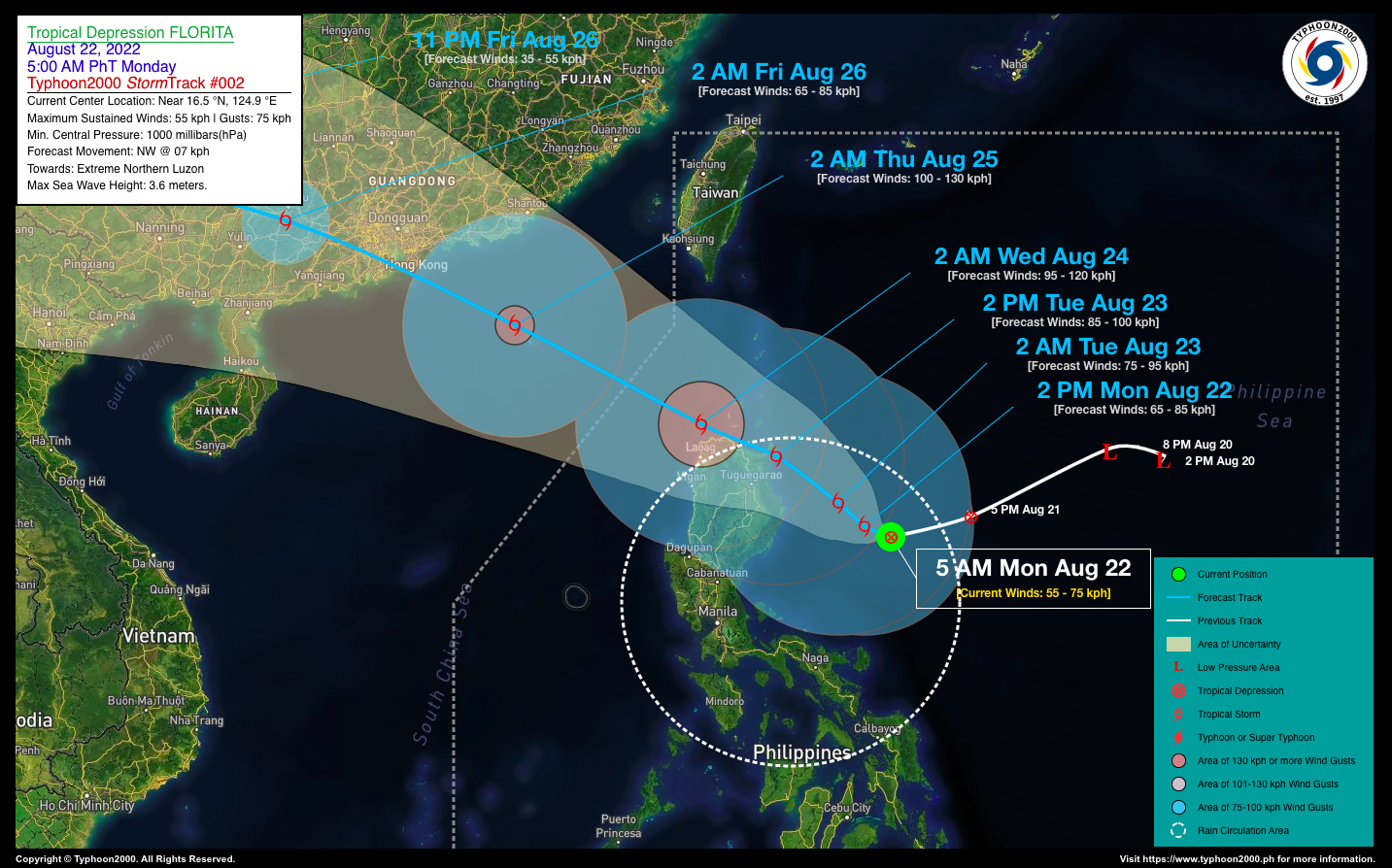
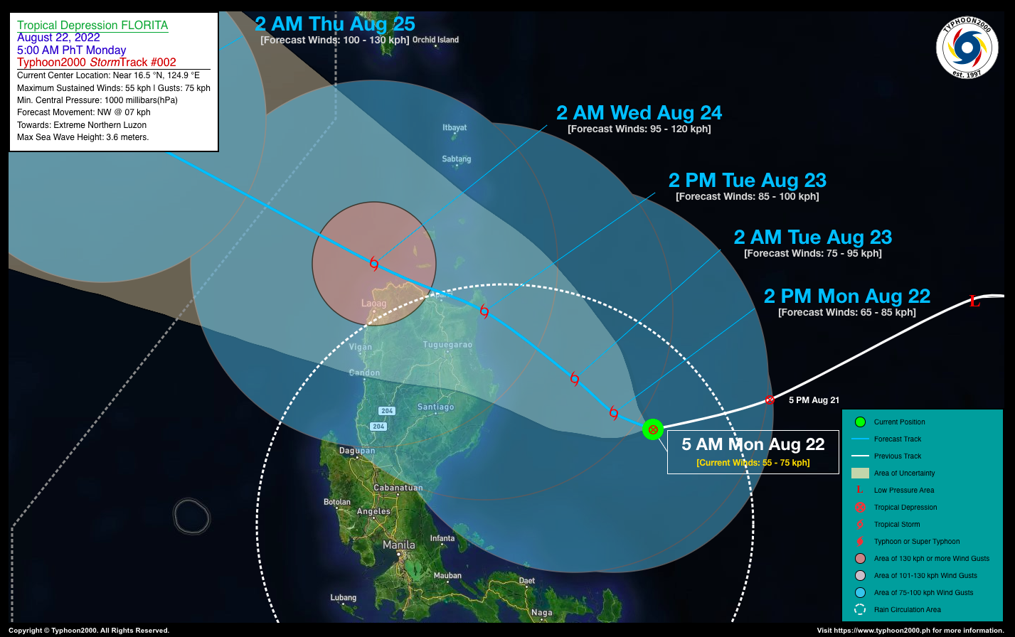
| Current Status & Outlook | Tropical Depression (TD) FLORITA has slightly intensified as it moves almost west-southwestward across the northwestern part of the Central Philippine Sea, east of Northern Aurora. Its thick rainbands is currently displaced to the west and southwest of its center due to strong upper-level winds (aka. Vertical Wind Shear).
24-hr Outlook: TD FLORITA is forecast to reach Tropical Storm (TS) Classification later today and will start moving slowly northwestward at a forward speed of 07 km/hr. Its displaced western rainbands will continue to affect the eastern & central sections of Cagayan Valley including Aurora today through tomorrow morning (Aug 23). Its trough or extension will bring rains and thunderstorms across Bicol Region, Quezon, Marinduque and the Rest of Aurora and has extended across Northern & Eastern Visayas, The Rest of Luzon including Metropolitan Manila today through tomorrow (Aug 23). |
| Where is FLORITA? | As of 5:00 AM PhT today, August 22…2100 GMT:
|
| How strong is it? | Maximum Sustained Winds (1-min avg): 55 kph near the center…Gustiness: 75 kph. |
| Past Movement (06 hrs) | West @ 22 kph, across the northwestern part of the Central Philippine Sea. |
| Potential Philippine Major Landfall Area(s) |
|
| What Philippine areas will be directly affected? | Heavy to Extreme Rainfall (50 mm to >100 mm expected for 24 hrs):
Damaging Winds (gusts of more than 100 km/hr expected):
|
| Potential Storm Surge/Coastal Flooding Areas+ |
+Waves of 3 meters in height are expected in storm surge-prone areas, particularly in coastal areas where the Tropical Cyclone is headed. Kindly visit the PAGASA Storm Surge Updates for more details. |
| 3-Day Forecast Outlook Summary** |
**Important Note: Please be reminded that the Forecast Outlook changes every 6 hours, and the Day 2 and 3 Forecast Track have an average error of 100 and 250 km respectively… while the wind speed forecast error, averages 35 km/hr per day. Therefore, a turn to the left or right of its future track and changes in its wind speed must be anticipated from time to time. |
| Other Storm’s Meteorological Information |
|
| Information based on data collected by Typhoon2000 (T2k) shall not be taken as official data. Weather information broadcasted and distributed by PAGASA remains as official data. Typhoon2000 (T2k) shall not be responsible for the private use and reliance of its weather information. | |
Issued by: David Michael V. Padua for Typhoon2000 (T2k)
Typhoon2000 (T2K) Integrated Multi-Agency Tracks
:: Not Yet Available
PAGASA TROPICAL CYCLONE WIND SIGNAL
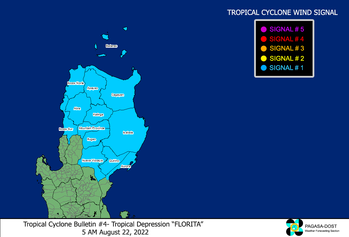
Image/Screenshot Source: DOST-PAGASA (https://bagong.pagasa.dost.gov.ph/tropical-cyclone/severe-weather-bulletin)


