


TROPICAL DEPRESSION FERDIE ADVISORY NO. 01Issued at: 1:00 AM PhT (17:00 GMT) Monday, 10 August 2020
Next update: 1:00 PM PhT (05:00 GMT) Monday, 10 August 2020 |
|
|---|---|
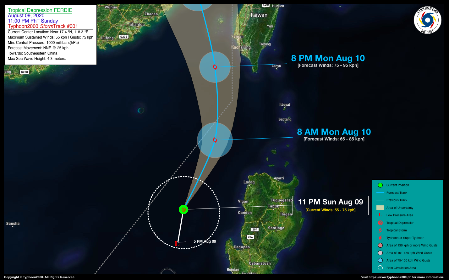
| Current Status and Outlook | Tropical Depression FERDIE newly-formed over the West Philippine Sea, west of Pangasinan…its eastern rainbands will bring occasional rains and gusty winds along the western coastal areas of Ilocos Region.
24-hr Outlook: TD FERDIE is forecast to intensify into a Tropical Storm within the next 12 to 24 hours and will move north-northeast with an increased forward speed of 25 km/hr towards Southeastern China. It will then exit the northwestern border of the Philippine Area of Responsibility (PAR) around noon or afternoon today. This depression will continue to enhance the Southwest Monsoon (Habagat) and bring overcast skies with occasional rains and gusty winds across the western sections of Luzon including Mindoro and Metropolitan Manila. |
| Where is FERDIE? | As of 11:00 PM PhT last night, August 09…1500 GMT. The center was located along the north-central portion of the West Philippine Sea (near 17.4°N 118.3°E), about 222 km west of Vigan City, Ilocos Sur or 264 km northwest of Dagupan City, Pangasinan. |
| How strong is it? | Maximum Sustained Winds (1-min avg): 55 kph near the center…Gustiness: 75 kph. |
| Past Movement (06 hrs) | North @ 21 kph, towards Southeastern China. |
| Potential Philippine Landfall Area(s) | :: None. |
| What Philippine areas will be directly affected? | Heavy to Extreme Rains (50 mm to >100 mm expected in 24 hrs): >> None. Damaging Winds (gusts of more than 100 km/hr expected): |
| Potential Storm Surge/Coastal Flooding Areas+ | :: None.
+Waves of 3 meters in height is expected in storm surge-prone areas, particularly in coastal areas on where the Tropical Cyclone is headed. Kindly visit the PAGASA Storm Surge Updates for more details. |
| 2-Day Forecast Outlook Summary** | MONDAY EVENING: Strengthens into a Tropical Storm as it exits the northwestern border of the Philippine Area of Responsibility (PAR)…about 110 km WSW of Kaohsiung City, Taiwan [8PM Aug 10: 22.1°N 119.4°E @ 75kph]. Confidence Level: HIGH.
TUESDAY EVENING: Weakens rapidly into a Tropical Disturbance (LPA) as it makes landfall over SE China…about 119 km WNW of Fuzhou, China [8PM Aug 11: 26.5°N 118.2°E @ 35kph]. Confidence Level: MEDIUM. **Important Note: Please be reminded that the Forecast Outlook changes every 6 hours, and the Day 2 and 3 Forecast Track have an average error of 100 and 250 km respectively… while the wind speed forecast error, averages 35 km/hr per day. Therefore, a turn to the left or right of its future track and changes in its wind speed must be anticipated from time to time. |
| Other Storm’s Meteorological Info | > 24 hr. Rain Accumulation (across its circulation): 25 to 110 mm [Light to Heavy]
> Minimum Central Pressure: 1000 millibars (hPa) > Size of Circulation [Convective Cloud-Based, in diameter]: 315 km (Very Small/Midget) > Area of Damaging Winds (100 kph or more wind gusts): None. |
| Current Summary/Additional Reference Points | Time/Date: 11:00 PM PhT Sun August 09, 2020 Location of Center/Eye: Near 17.4°N Lat 118.3°E Lon Distance 1: 237 km WNW of San Fernando City, La Union Distance 2: 272 km NW of San Carlos City, Pangasinan Distance 3: 298 km WSW of Pagudpud, Ilocos Norte Distance 4: 333 km W of Tabuk City, Kalinga Distance 5: 431 km NW of Metro Manila 24 hr. Forecast Coordinates (Class): 22.1°N 119.4°E (TS) 48 hr. Forecast Coordinates (Class): 26.5°N 118.2°E (LPA) |
| Information based on data collected by Typhoon2000 (T2k) shall not be taken as official data. Weather information broadcasted and distributed by PAGASA remains as official data. Typhoon2000 (T2k) shall not be responsible for the private use and reliance of its weather information. | |
Issued by: David Michael V. Padua for Typhoon2000 (T2K)
PAGASA TROPICAL CYCLONE WIND SIGNAL

Image Source: DOST-PAGASA (http://pubfiles.pagasa.dost.


