
TROPICAL STORM FERDIE (MEKKHALA) ADVISORY NO. 02 [FINAL]Issued at: 1:00 PM PhT (05:00 GMT) Monday, 10 August 2020
|
|
|---|---|
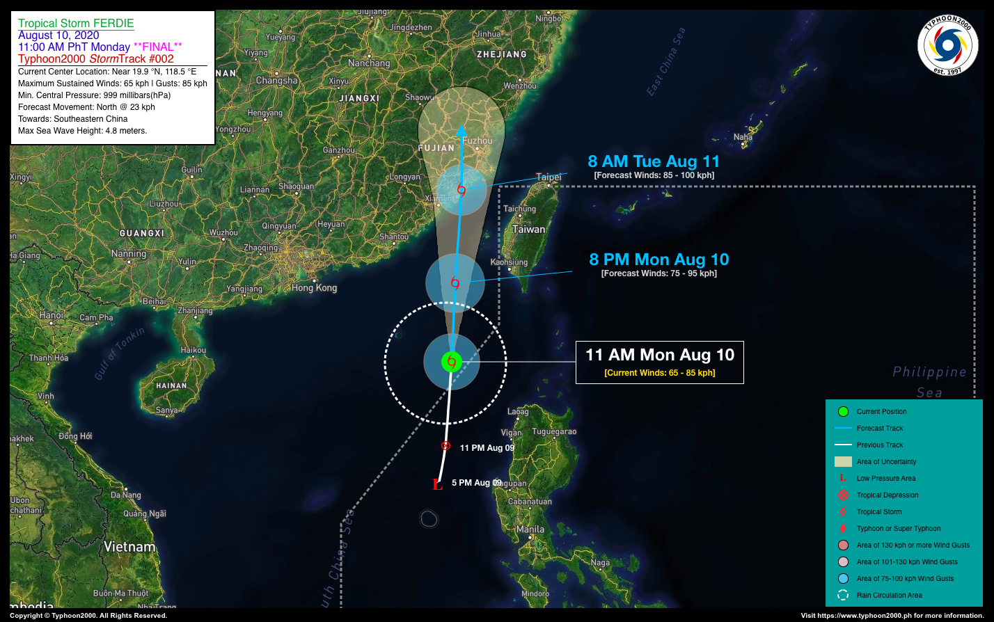
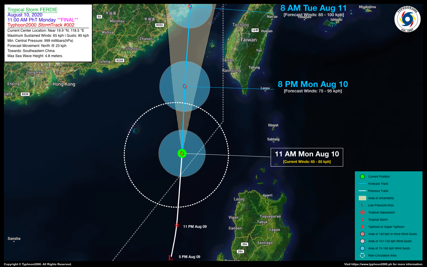
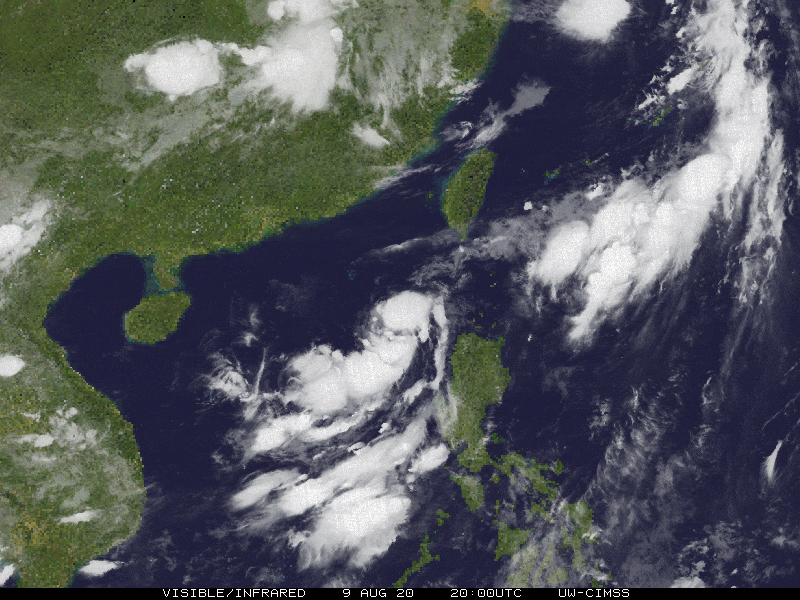
| Current Status and Outlook | FERDIE (MEKKHALA) becomes a Tropical Storm (TS) as it swiftly moved out of the Philippine Area of Responsibility (PAR), on it way towards Southeastern China.
*With this development, this is the Final Advisory on this Tropical Cyclone. 24-hr Outlook: TS FERDIE (MEKKHALA) is forecast to intensify further within the next 12 to 24 hours prior in making landfall to Fujian Province, China and will continue moving northward with an increased forward speed of 27 km/hr. It will then make landfall just to the east of Xiamen, China around tomorrow, Tuesday morning (Aug 11). This storm will continue to enhance the Southwest Monsoon (Habagat) and bring overcast skies with occasional rains and gusty winds across the western sections of Luzon including Occidental Mindoro and Metropolitan Manila. |
| Where is FERDIE (MEKKHALA)? | As of 11:00 AM PhT today, August 10…0300 GMT. The center was located along the western section of Balintang and Bashi Channels (near 19.9°N 118.5°E), about 284 km west-northwest of Pagudpud, Ilocos Norte or 371 km west of Basco, Batanes. |
| How strong is it? | Maximum Sustained Winds (1-min avg): 65 kph near the center…Gustiness: 85 kph. |
| Past Movement (06 hrs) | North @ 23 kph, towards Southeastern China. |
| Potential Philippine Landfall Area(s) | :: None. |
| What Philippine areas will be directly affected? | Heavy to Extreme Rains (50 mm to >100 mm expected in 24 hrs): >> None. Damaging Winds (gusts of more than 100 km/hr expected): |
| Potential Storm Surge/Coastal Flooding Areas+ | :: None.
+Waves of 3 meters in height is expected in storm surge-prone areas, particularly in coastal areas on where the Tropical Cyclone is headed. Kindly visit the PAGASA Storm Surge Updates for more details. |
| 1-Day Forecast Outlook Summary** | TUESDAY MORNING: Strengthens further as it starts to make landfall over Fujian Province, China…about 13 km ENE of Quanzhou, China [8AM Aug 11: 24.9°N 118.8°E @ 85kph]. Confidence Level: MEDIUM.
TUESDAY EVENING: Weakens rapidly into a Tropical Depression (TD) as it traverses the mountainous terrain of Northern Fujian, China…about 119 km WNW of Fuzhou, China [8PM Aug 11: 26.6°N 118.8°E @ 55kph]. Confidence Level: MEDIUM. **Important Note: Please be reminded that the Forecast Outlook changes every 6 hours, and the Day 2 and 3 Forecast Track have an average error of 100 and 250 km respectively… while the wind speed forecast error, averages 35 km/hr per day. Therefore, a turn to the left or right of its future track and changes in its wind speed must be anticipated from time to time. |
| Other Storm’s Meteorological Info | > 24 hr. Rain Accumulation (across its circulation): 25 to 120 mm [Light to Heavy]
> Minimum Central Pressure: 999 millibars (hPa) > Size of Circulation [Convective Cloud-Based, in diameter]: 320 km (Very Small/Midget) > Area of Damaging Winds (100 kph or more wind gusts): None. |
| Current Summary/Additional Reference Points | Time/Date: 11:00 AM PhT Mon August 10, 2020 Location of Center/Eye: Near 19.9°N Lat 118.5°E Lon Distance 1: 317 km WNW of Calayan Island, Cagayan Distance 2: 356 km SSW of Kaohsiung, Taiwan Distance 3: 372 km WNW of Aparri, Cagayan Distance 4: 415 km WNW of Santa Ana, Cagayan Distance 5: 652 km NNW of Metro Manila 24 hr. Forecast Coordinates (Class): 24.9°N 118.8°E (TS) 36 hr. Forecast Coordinates (Class): 26.6°N 118.8°E (TD) |
| Information based on data collected by Typhoon2000 (T2k) shall not be taken as official data. Weather information broadcasted and distributed by PAGASA remains as official data. Typhoon2000 (T2k) shall not be responsible for the private use and reliance of its weather information. | |
Issued by: David Michael V. Padua for Typhoon2000 (T2K)


