

TROPICAL DISTURBANCE (LPA) AGATON (MEGI) ADVISORY NO. 06 **FINAL**Issued at: 7:00 AM PhT (23:00 GMT) Tuesday, 12 April 2022
|
|
|---|---|
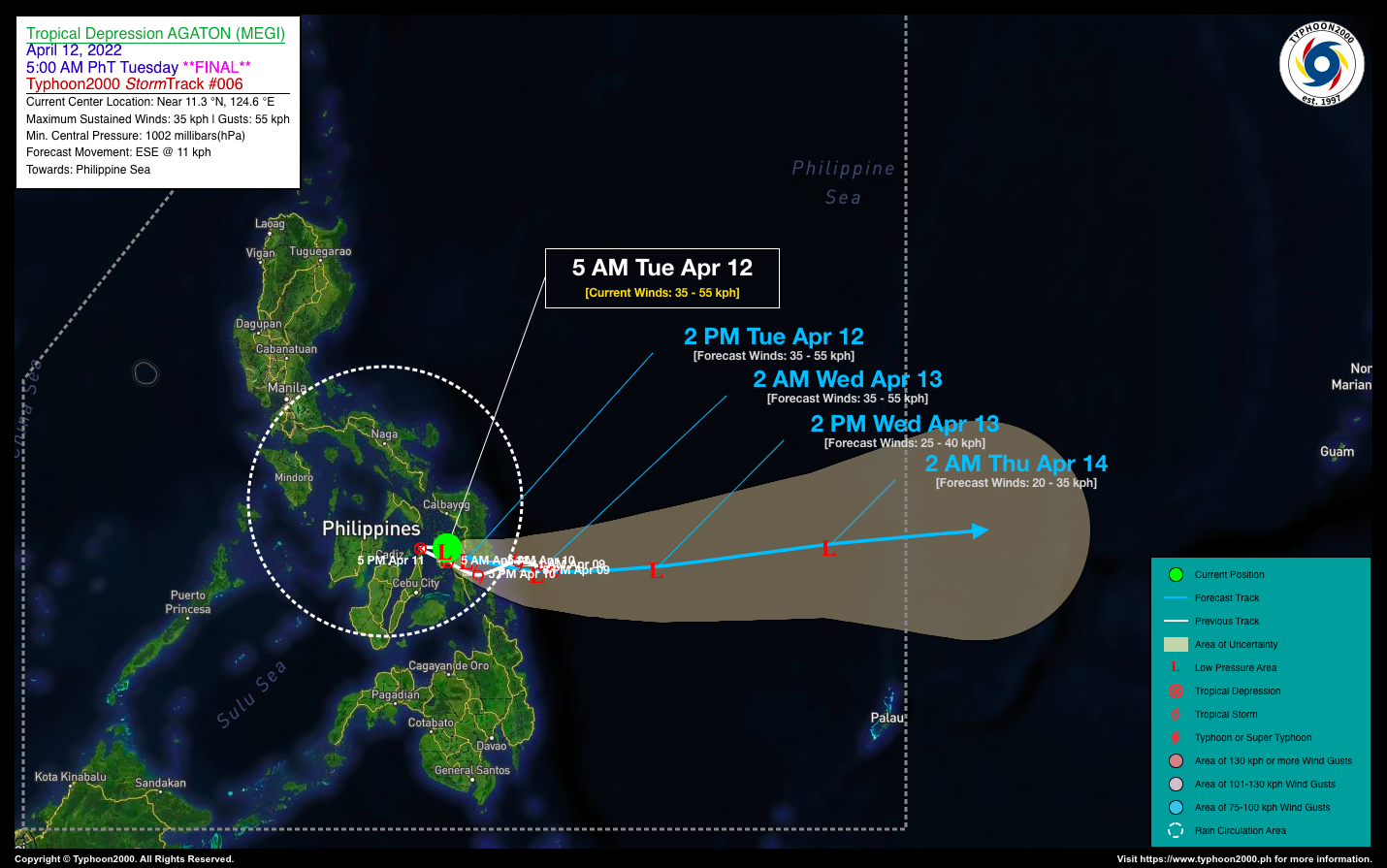
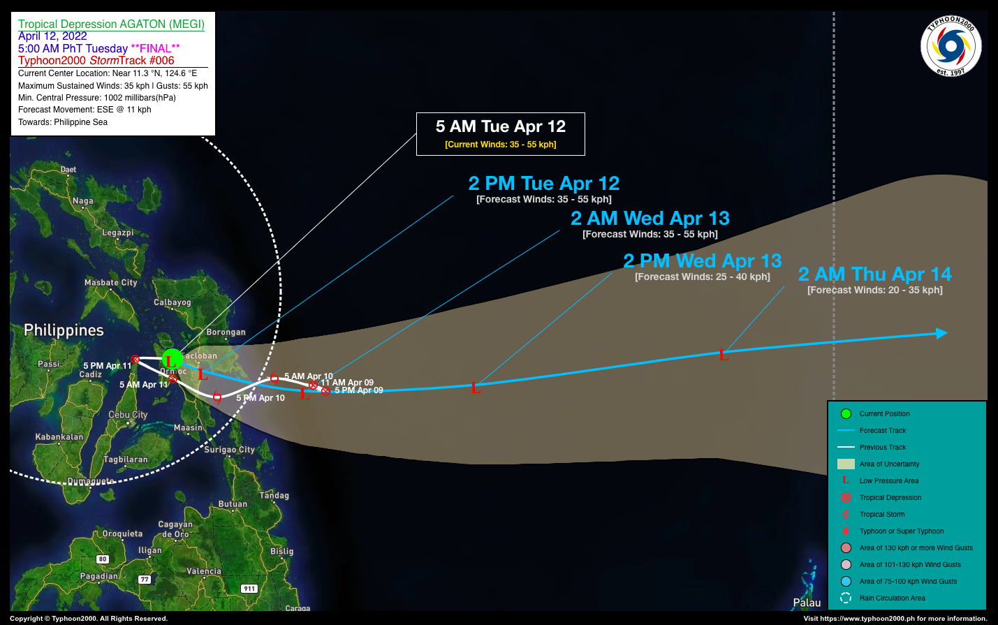
| Current Status & Outlook | Tropical Depression AGATON (MEGI) has weakened considerably into a Tropical Disturbance (LPA) as it drifts back eastward across Northern Leyte…expected to emerge over the Philippine Sea within the next 12-24 hours.
*This is the Final Advisory on this Tropical Cyclone. 24-hr Outlook: The remnants of AGATON is forecast to weaken further while traversing ESE @ 11 kph across the northern part of Leyte Gulf or along the southern coastline of Eastern Samar. By early tomorrow morning, its remnants will be well over the Philippine Sea, as it becomes a part of Typhoon Malakas’ large circulation. Meanwhile, Severe Tropical Storm (STS) MALAKAS has intensified into a 120-kph Typhoon as it remains outside of the Philippine Area of Responsibility (PAR). New forecast suggests the large typhoon may no longer enter PAR as it continues to track north towards the sea south of Japan. |
| Where is AGATON (MEGI)? | As of 5:00 AM PhT today, April 12…2100 GMT:
|
| How strong is it? | Maximum Sustained Winds (1-min avg): 35 kph near the center…Gustiness: 55 kph. |
| Past Movement (06 hrs) | East-Southeast @ 06 kph, towards Leyte Gulf-Philippine Sea Area. |
| Potential Philippine Major Landfall Area(s) |
|
| What Philippine areas will be directly affected? | Heavy to Extreme Rainfall (50 mm to >100 mm expected for 24 hrs):
Damaging Winds (gusts of more than 100 km/hr expected):
|
| Potential Storm Surge/Coastal Flooding Areas+ |
+Waves of 3 meters in height are expected in storm surge-prone areas, particularly in coastal areas where the Tropical Cyclone is headed. Kindly visit the PAGASA Storm Surge Updates for more details. |
| 2-Day Forecast Outlook Summary** |
**Important Note: Please be reminded that the Forecast Outlook changes every 6 hours, and the Day 2 and 3 Forecast Track have an average error of 100 and 250 km respectively… while the wind speed forecast error, averages 35 km/hr per day. Therefore, a turn to the left or right of its future track and changes in its wind speed must be anticipated from time to time. |
| Other Storm’s Meteorological Information |
|
| Information based on data collected by Typhoon2000 (T2k) shall not be taken as official data. Weather information broadcasted and distributed by PAGASA remains as official data. Typhoon2000 (T2k) shall not be responsible for the private use and reliance of its weather information. | |
Issued by: David Michael V. Padua for Typhoon2000 (T2k)
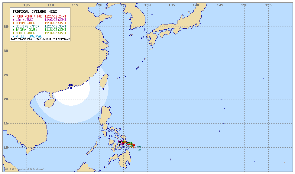
Typhoon2000 (T2K) Integrated Multi-Agency Tracks
PAGASA TROPICAL CYCLONE WIND SIGNAL

Image/Screenshot Source: DOST-PAGASA (http://bagong.pagasa.dost.gov.ph/tropical-cyclone-bulletin-iframe)


