
SEVERE TROPICAL STORM ULYSSES (VAMCO) ADVISORY NO. 06Issued at: 7:00 AM PhT (23:00 GMT) Wednesday, 11 November 2020
Next update: 1:00 PM PhT (05:00 GMT) Wednesday, 11 November 2020 |
|
|---|---|
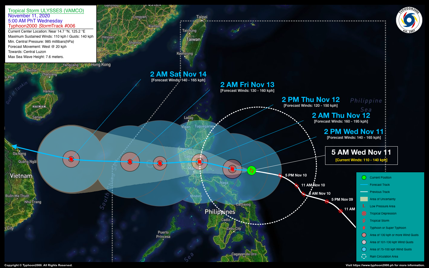
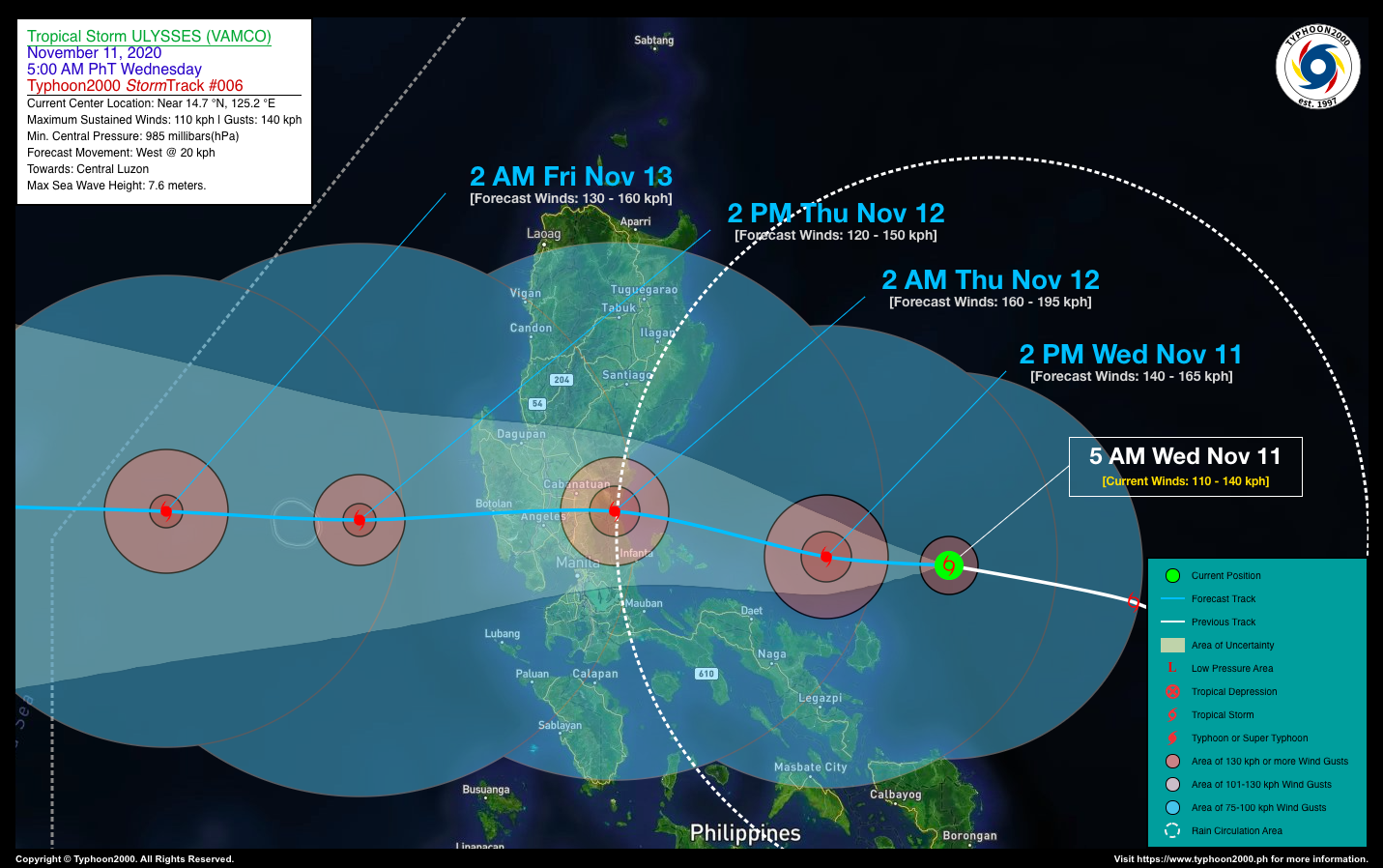
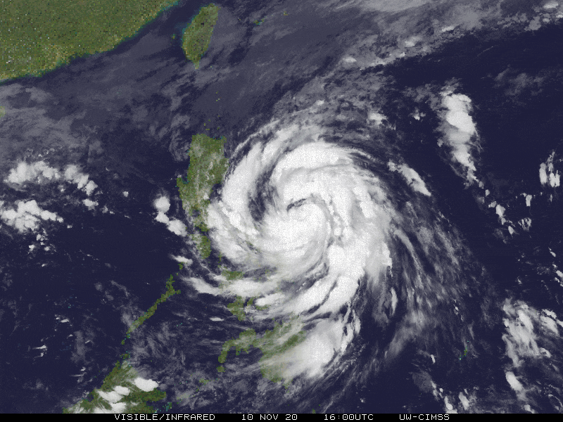
| Current Status & Outlook | ULYSSES (VAMCO) has intensified rapidly into a Severe Tropical Storm (STS) and is likely to reach Typhoon classification today. The motion of this system has moved more to the west-northwest with a possible landfall over Northern Quezon-Southern Aurora Area by early Thursday morning.
24-hr Outlook: STS ULYSSES (VAMCO) is forecast to move almost westward with a forward speed of 20 km/hr, and could become a Category 1 Typhoon (TY) today. The developing core (eye+eyewall) is expected to pass more or less 150 km north of Naga City, Camarines Sur between 2 to 5 PM this afternoon, and over or very close to Polillo Island Group before midnight tonight. It shall eventually make landfall along or very near the Southern Aurora-Northern Quezon Border at around 2 AM tomorrow (Nov 12), and will traverse Central Luzon across the provinces of Nueva Ecija, Pampanga, and Zambales between 4 to 8 AM tomorrow. By tomorrow afternoon, the core of Ulysses will emerge over the West Philippine Sea, accelerating westward. |
| Where is ULYSSES (VAMCO)? | As of 5:00 AM PhT today, November 11…2100 GMT:
|
| How strong is it? | Maximum Sustained Winds (1-min avg): 110 kph near the center…Gustiness: 140 kph. |
| Past Movement (06 hrs) | West-Northwest @ 18 kph, across the Central Philippine Sea |
| Potential Philippine Landfall Area(s) |
|
| What Philippine areas will be directly affected? | Heavy to Extreme Rainfall (50 mm to >100 mm expected for 24 hrs):
Damaging Winds (gusts of more than 100 km/hr expected):
|
| Potential Storm Surge/Coastal Flooding Areas+ |
+Waves of 3 meters in height is expected in storm surge-prone areas, particularly in coastal areas on where the Tropical Cyclone is headed. Kindly visit the PAGASA Storm Surge Updates for more details. |
| 3-Day Forecast Outlook Summary** |
**Important Note: Please be reminded that the Forecast Outlook changes every 6 hours, and the Day 2 and 3 Forecast Track have an average error of 100 and 250 km respectively… while the wind speed forecast error, averages 35 km/hr per day. Therefore, a turn to the left or right of its future track and changes in its wind speed must be anticipated from time to time. |
| Other Storm’s Meteorological Information |
|
| Information based on data collected by Typhoon2000 (T2k) shall not be taken as official data. Weather information broadcasted and distributed by PAGASA remains as official data. Typhoon2000 (T2k) shall not be responsible for the private use and reliance of its weather information. | |
Issued by: David Michael V. Padua for Typhoon2000 (T2K)
Typhoon2000 (T2K) Integrated Multi-Agency Tracks

For more info: http://www.typhoon2000.ph/multi/?name=VAMCO
PAGASA TROPICAL CYCLONE WIND SIGNAL

Image/Screenshot Source: DOST-PAGASA (http://pubfiles.pagasa.dost.


