

TROPICAL DEPRESSION QUINTA ADVISORY NO. 03Issued at: 7:00 PM PhT (11:00 GMT) Saturday, 24 October 2020
Next update: 7:00 AM PhT (23:00 GMT) Sunday, 25 October 2020 |
|
|---|---|
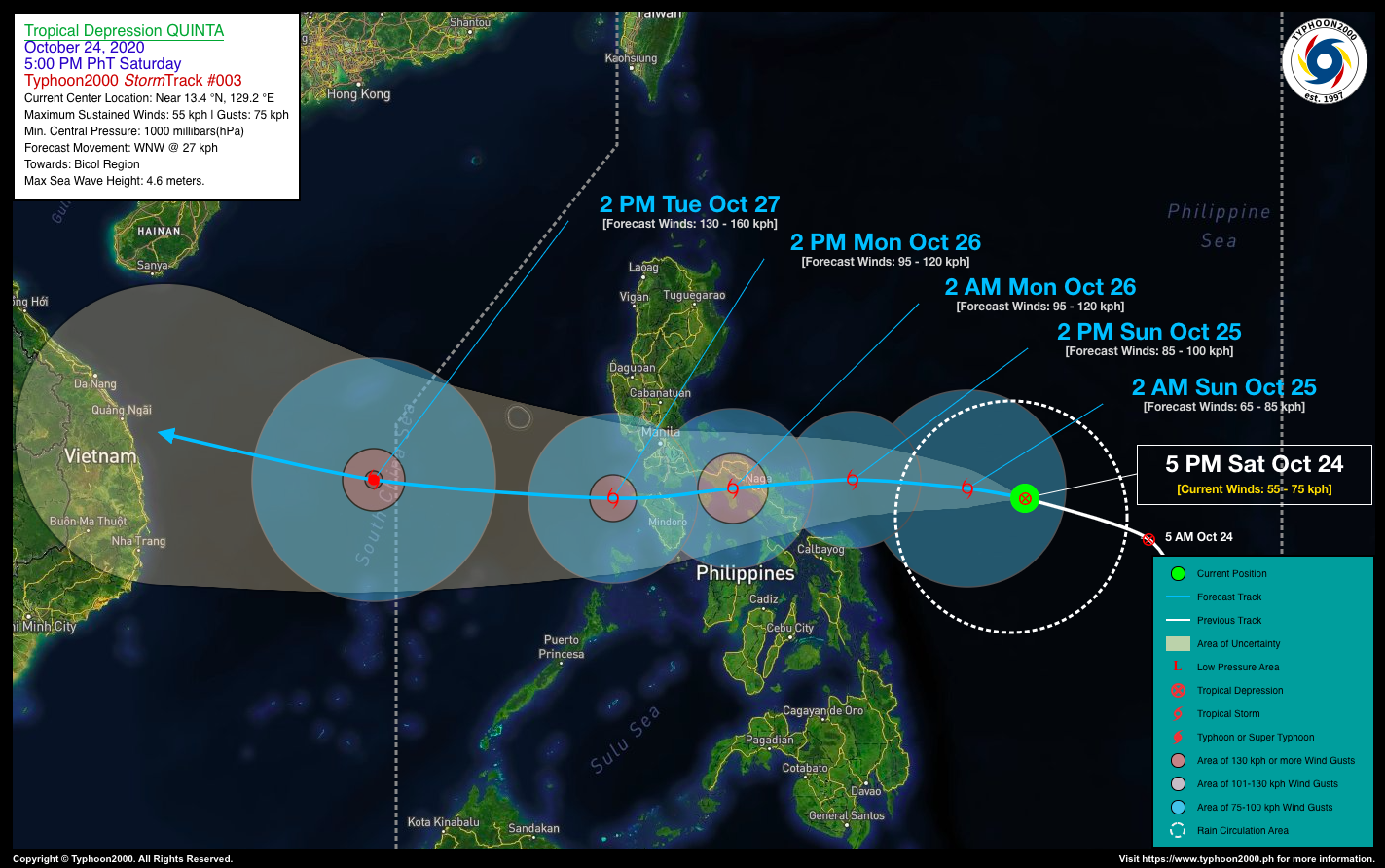
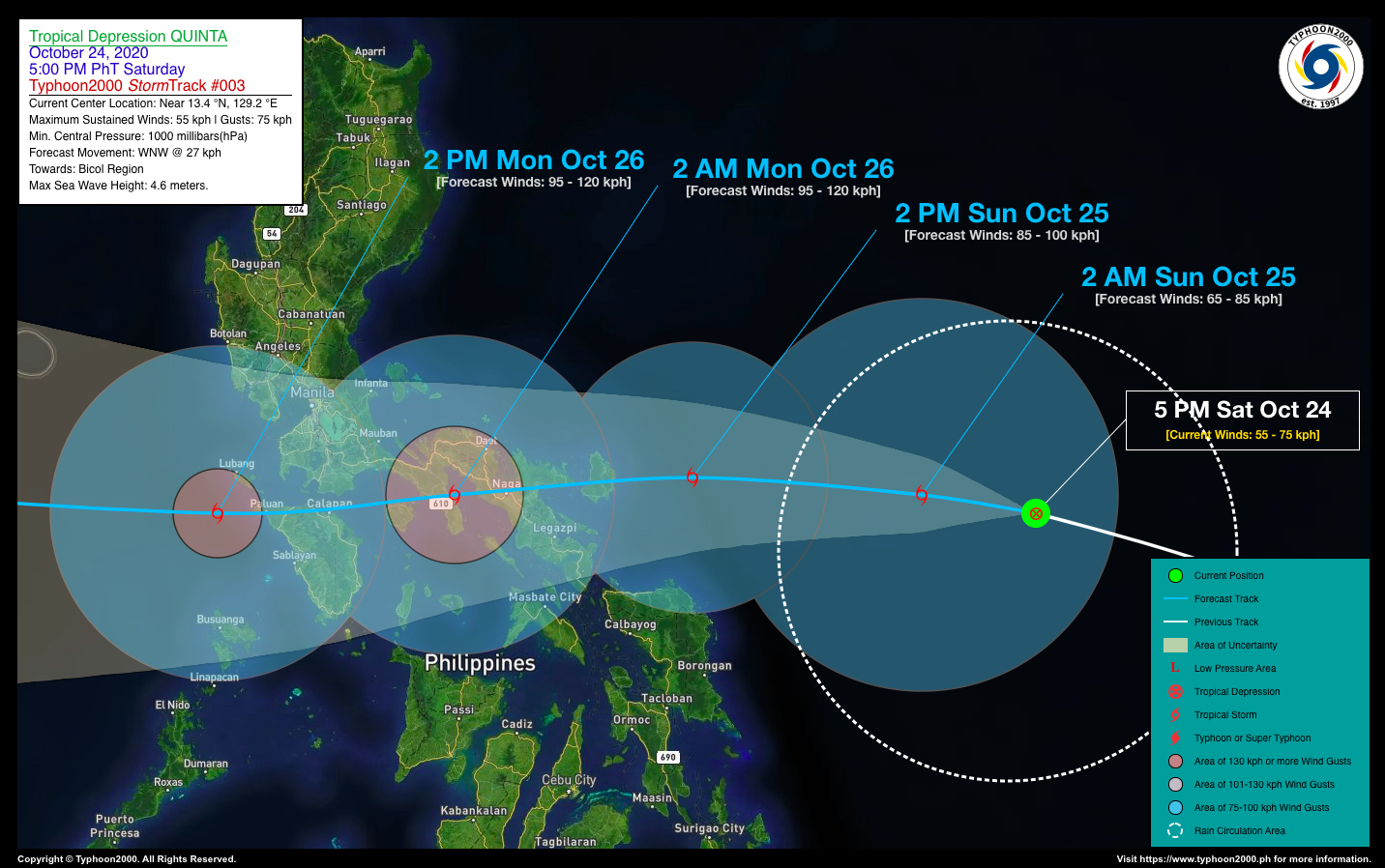
| Current Status and Outlook | Tropical Depression QUINTA continues to consolidate and intensify over the Philippine Sea as it maintains its fast, west-northwest track towards the Bicol Region…likely to become a Severe Tropical Storm (STS) on or before it makes landfall over Catanduanes and Camarines Sur by tomorrow evening.
24-hr Outlook: TD QUINTA is forecast to become a Tropical Storm (TS) later tonight and shall turn westward with a decreased forward speed of 20 km/hr towards western portion of the Central Philippine Sea…approaching the east coast of Catanduanes by tomorrow afternoon, with potential wind speeds of 85 or 95 km/hr. |
| Where is QUINTA? | As of 5:00 PM PhT today, October 24…0900 GMT. The center was located along the middle portion of the Central Philippine Sea (near 13.4°N 129.2°E), about 536 km east of Virac, Catanduanes or 642 km east of Naga City, Camarines Sur. |
| How strong is it? | Maximum Sustained Winds (1-min avg): 55 kph near the center…Gustiness: 75 kph. |
| Past Movement (06 hrs) | West-Northwest @ 27 kph, towards the Bicol Region |
| Potential Philippine Landfall Area(s) | :: Landfall 1: Over Catanduanes, between 6-8 PM tomorrow, Sunday evening (Oct 25) – with High Strike Probability of 80%.
:: Landfall 2: Over Camarines Sur, between 9 PM tomorrow, Sunday evening (Oct 25) to 12 midnight (Oct 26) – with High Strike Probability of 75%. |
| What Philippine areas will be directly affected? | Heavy to Extreme Rains (50 mm to >100 mm expected in 24 hrs): >> Bicol Region, Eastern & Northern Samar – beginning Sunday afternoon (Oct 25) until Monday morning (Oct 26). >> Calabarzon, Mindoro, Marinduque, Romblon – beginning Monday early morning until the evening (Oct 26). Damaging Winds (gusts of more than 100 km/hr expected): |
| Potential Storm Surge/Coastal Flooding Areas+ | :: None.
+Waves of 3 meters in height is expected in storm surge-prone areas, particularly in coastal areas on where the Tropical Cyclone is headed. Kindly visit the PAGASA Storm Surge Updates for more details. |
| 3-Day Forecast Outlook Summary** | SUNDAY AFTERNOON: Strengthens into a TS as it turns westward approaching Bicol Region…about 108 km ENE of Bato, Catanduanes [2PM Oct 25: 13.8°N 125.3°E @ 85 kph]. Confidence Level: HIGH
MONDAY AFTERNOON: Emerges over the West Philippine Sea after traversing Bicol Region, Bondoc Peninsula, Marinduque, & Romblon…intensifies into a Severe Tropical Storm (STS)…about 131 km WSW of Batangas City, Batangas [2PM Oct 26: 13.4°N 119.9°E @ 95 kph]. Confidence Level: HIGH TUESDAY AFTERNOON: Exits the western border of the Philippine Area of Responsibility (PAR) and becomes a Category 1 Typhoon (TY) as traverses the South China Sea towards Vietnam…about 632 km NW of Puerto Princesa City, Palawan [2PM Oct 27: 13.8°N 114.5°E @ 130 kph]. Confidence Level: MEDIUM **Important Note: Please be reminded that the Forecast Outlook changes every 6 hours, and the Day 2 and 3 Forecast Track have an average error of 100 and 250 km respectively… while the wind speed forecast error, averages 35 km/hr per day. Therefore, a turn to the left or right of its future track and changes in its wind speed must be anticipated from time to time. |
| Other Storm’s Meteorological Info | > 24 hr. Rain Accumulation (across its circulation): 25 to 200 mm [Light to Heavy]
> Minimum Central Pressure: 1000 millibars (hPa) > Size of Circulation [Convective Cloud-Based, in diameter]: 625 km (Small) > Area of Damaging Winds (100 kph or more wind gusts): None. |
| Current Summary/Additional Reference Points | Time/Date: 5:00 PM PhT Sat October 24, 2020 Location of Center/Eye: Near 13.4°N Lat 129.2°E Lon Distance 1: 563 km E of Sorsogon City, Sorsogon Distance 2: 593 km E of Legazpi City, Albay Distance 3: 630 km E of Iriga City, Camarines Sur Distance 4: 680 km E of Daet City, Camarines Norte Distance 5: 888 km E of Metro Manila |
| Information based on data collected by Typhoon2000 (T2k) shall not be taken as official data. Weather information broadcasted and distributed by PAGASA remains as official data. Typhoon2000 (T2k) shall not be responsible for the private use and reliance of its weather information. | |
Issued by: David Michael V. Padua for Typhoon2000 (T2K)
PAGASA TROPICAL CYCLONE WIND SIGNAL
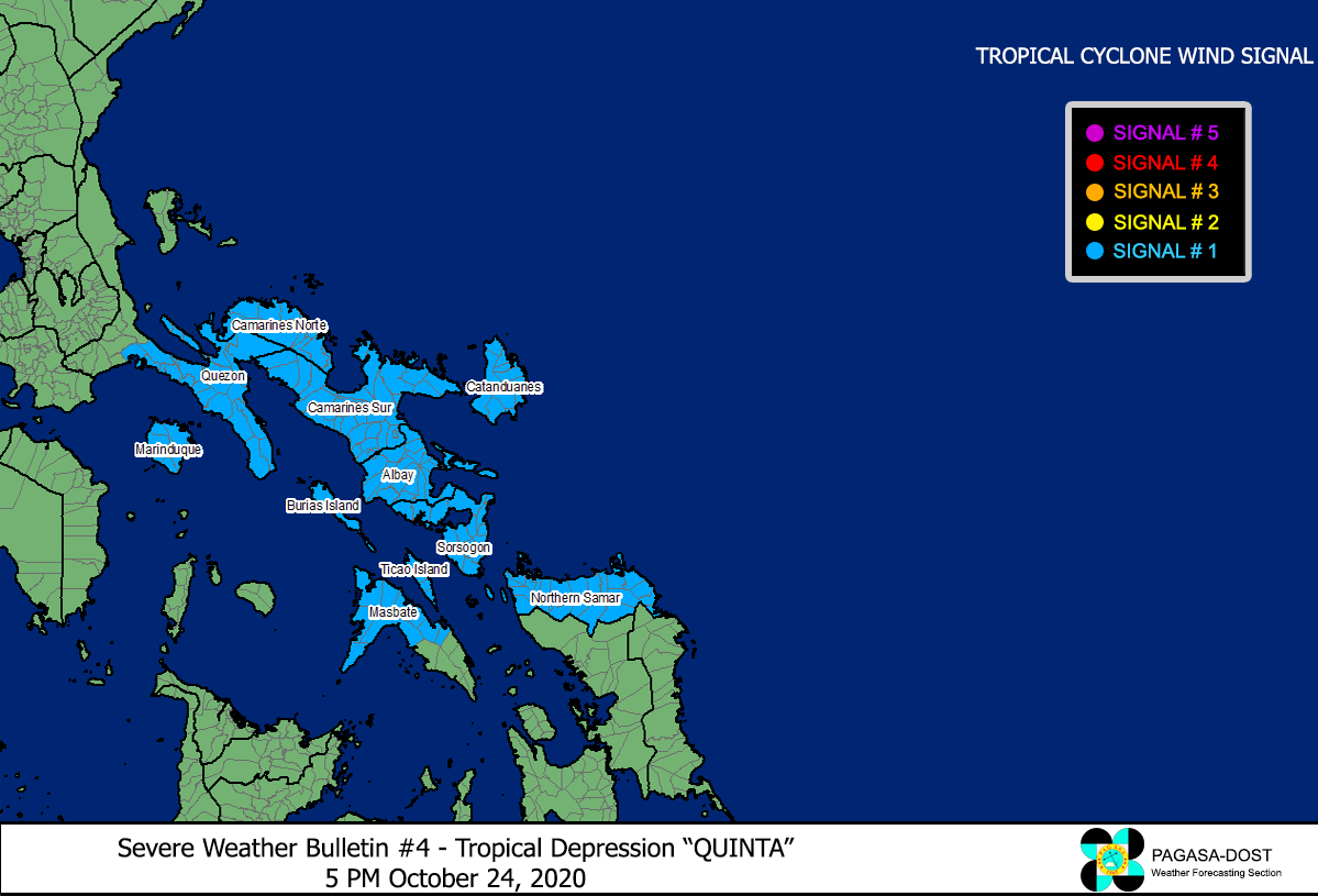
Image Source: DOST-PAGASA (http://pubfiles.pagasa.dost.


