

TROPICAL DEPRESSION QUINTA ADVISORY NO. 02Issued at: 7:00 AM PhT (23:00 GMT) Saturday, 24 October 2020
Next update: 7:00 PM PhT (11:00 GMT) Saturday, 24 October 2020 |
|
|---|---|
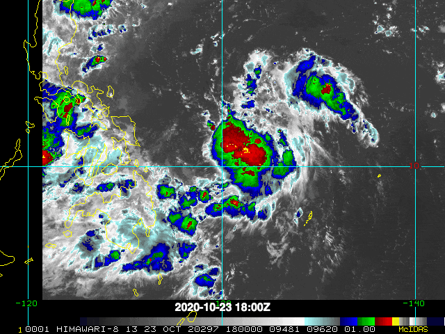
| Current Status and Outlook | Tropical Depression QUINTA still organizing over the Philippine Sea as it moved northwestward during the past 12 hours…remains a threat to Eastern Visayas & Bicol Region.
24-hr Outlook: TD QUINTA is forecast to become a Tropical Storm (TS) later tonight and shall turn west-northwest to westward with a forward speed of 20 km/hr towards western portion of the Central Philippine Sea, closer to the eastern coast of Bicol Region. |
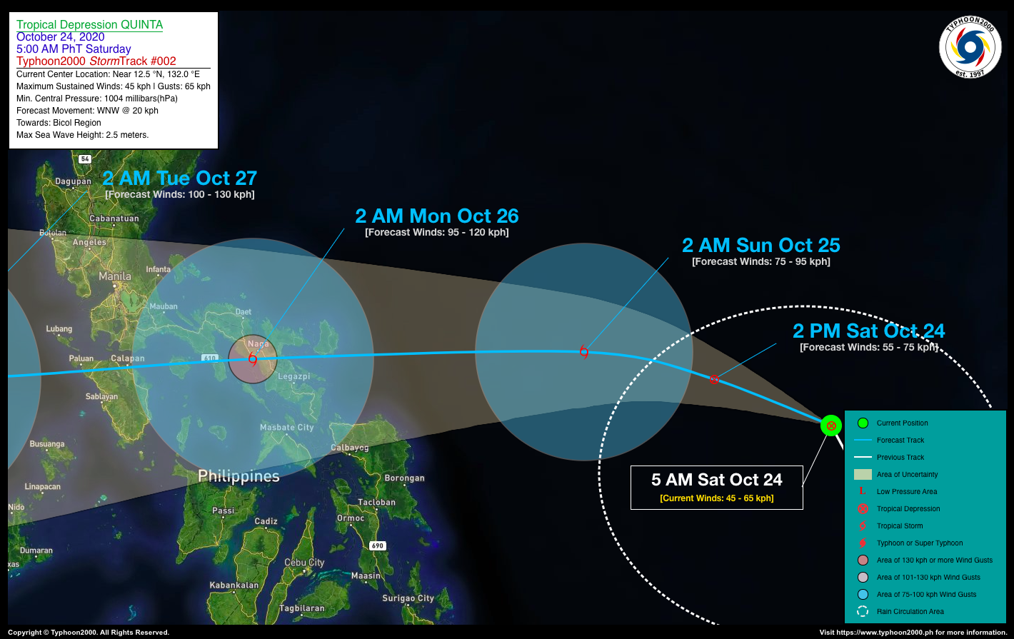
| Where is QUINTA? | As of 5:00 AM PhT today, October 24…2100 GMT. The center was located along the Southeastern Portion of the Central Philippine Sea (near 12.5°N 132.0°E), about 702 km east-northeast of Guiuan, Eastern Samar or 855 km east of Virac, Catanduanes. |
| How strong is it? | Maximum Sustained Winds (1-min avg): 45 kph near the center…Gustiness: 65 kph. |
| Past Movement (06 hrs) | Northwest @ 20 kph, towards the Bicol Region |
| Potential Philippine Landfall Area(s) | :: Over Southern Catanduanes, between 11 PM Sunday evening to 12 AM Monday morning (Oct 25 to 26) – with High Strike Probability of 70%. |
| What Philippine areas will be directly affected? | Heavy to Extreme Rains (50 mm to >100 mm expected in 24 hrs): >> Bicol Region, Eastern & Northern Samar – beginning Sunday, Oct 25. Damaging Winds (gusts of more than 100 km/hr expected): |
| Potential Storm Surge/Coastal Flooding Areas+ | :: None.
+Waves of 3 meters in height is expected in storm surge-prone areas, particularly in coastal areas on where the Tropical Cyclone is headed. Kindly visit the PAGASA Storm Surge Updates for more details. |
| 3-Day Forecast Outlook Summary** | SUNDAY EARLY MORNING: Strengthens into a TS as it turns westward while over the Central Philippine Sea…about 433 km E of Virac, Catanduanes [2AM Oct 25: 13.6°N 128.2°E @ 75 kph]. Confidence Level: MEDIUM
MONDAY EARLY MORNING: In the vicinity of Pasacao, Camarines Sur as it intensifies into a Severe Tropical Storm (STS) prior in making landfall over Catanduanes & Camarines Sur…about 15 km SW of Naga City, Camarines Sur [2AM Oct 26: 13.5°N 123.1°E @ 95 kph]. Confidence Level: HIGH TUESDAY EARLY MORNING: Over the West Philippine Sea while intensifying further as it heads west towards Vietnam…about 298 km WNW of Coron, Palawan [2AM Oct 27: 13.2°N 117.7°E @ 100 kph]. Confidence Level: LOW **Important Note: Please be reminded that the Forecast Outlook changes every 6 hours, and the Day 2 and 3 Forecast Track have an average error of 100 and 250 km respectively… while the wind speed forecast error, averages 35 km/hr per day. Therefore, a turn to the left or right of its future track and changes in its wind speed must be anticipated from time to time. |
| Other Storm’s Meteorological Info | > 24 hr. Rain Accumulation (across its circulation): 25 to 200 mm [Light to Heavy]
> Minimum Central Pressure: 1004 millibars (hPa) > Size of Circulation [Convective Cloud-Based, in diameter]: 540 km (Small) > Area of Damaging Winds (100 kph or more wind gusts): None. |
| Current Summary/Additional Reference Points | Time/Date: 5:00 AM PhT Sat October 24, 2020 Location of Center/Eye: Near 12.5°N Lat 132.0°E Lon Distance 1: 805 km E of Catarman, Northern Samar Distance 2: 904 km E of Legazpi City, Albay Distance 3: 938 km E of Iriga City, Camarines Sur Distance 4: 962 km E of Naga City, Camarines Sur Distance 5: 1205 km ESE of Metro Manila |
| Information based on data collected by Typhoon2000 (T2k) shall not be taken as official data. Weather information broadcasted and distributed by PAGASA remains as official data. Typhoon2000 (T2k) shall not be responsible for the private use and reliance of its weather information. | |
Issued by: David Michael V. Padua for Typhoon2000 (T2K)
PAGASA TROPICAL CYCLONE WIND SIGNAL
:: None Yet ::
Image Source: DOST-PAGASA (http://pubfiles.pagasa.dost.


