

TROPICAL STORM PEPITO (SAUDEL) ADVISORY NO. 06Issued at: 7:00 PM PhT (11:00 GMT) Tuesday, 20 October 2020
Next update: 1:00 AM PhT (17:00 GMT) Wednesday, 21 October 2020 |
|
|---|---|
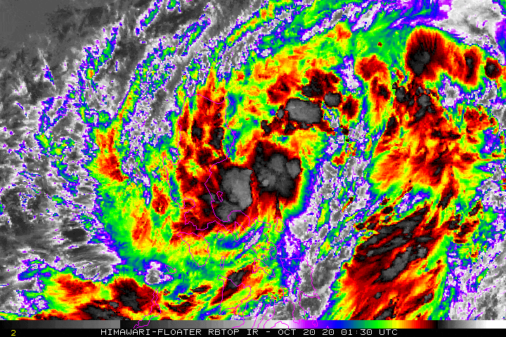
| Current Status and Outlook | Tropical Storm PEPITO (SAUDEL) continues to intensify as it approaches the coastline of Aurora…landfall likely to occur within the next few hours. Renewed Rainbands are producing thunderstorms across Central Luzon including Metro Manila as the system prepares to move over land.
24-hr Outlook: TS PEPITO (SAUDEL) will maintain its strength as it turns more to the west with a decreased forward speed of 21 km/hr, and will cross the northern part of Central Luzon tonight through early tomorrow morning, traversing the provinces of Nueva Ecija, Tarlac, Pangasinan, & Northern Zambales. The storm will eventually emerge over the west coast of Northern Zambales or Western Pangasinan on or before sunrise tomorrow, and will be over the open waters of the West Philippine Sea by tomorrow afternoon. The combination of the Pepito’s Rainbands, Trough and the Enhanced Northeasterly & Southwesterly Surface Windflows will bring overcast skies with scattered to widespread “on-&-off” rain showers and thunderstorms across Luzon and Visayas including MiMaRoPa, Sulu Archipelago, and Western Mindanao tonight and tomorrow. |
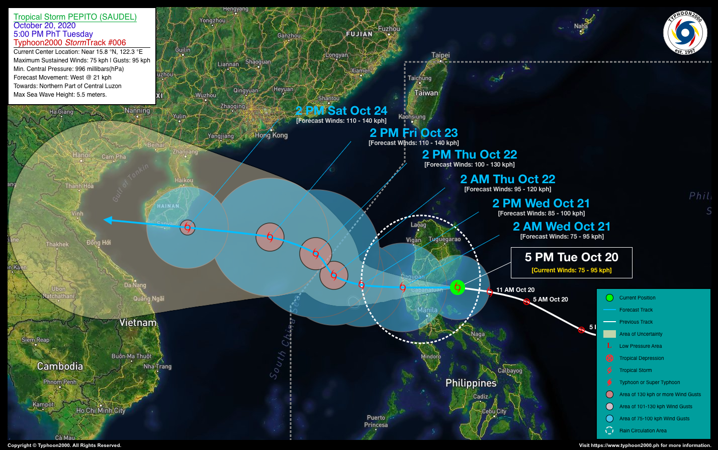
| Where is PEPITO (SAUDEL)? | As of 5:00 PM PhT today, October 20…0900 GMT. The center was located approaching the coastal waters of Aurora (near 15.8°N 122.3°E), about 76 km east of Baler, Aurora or 54 km south-southeast of Casiguran, Aurora. |
| How strong is it? | Maximum Sustained Winds (1-min avg): 75 kph near the center…Gustiness: 95 kph. |
| Past Movement (06 hrs) | West @ 25 kph, towards the Northern Part of Central Luzon. |
| Potential Philippine Landfall Area(s) | :: Somewhere along the Coastal Towns of Baler & Dipaculao, Aurora, between 7 to 9 PM local time Tonight – with High Strike Probability of 90%. |
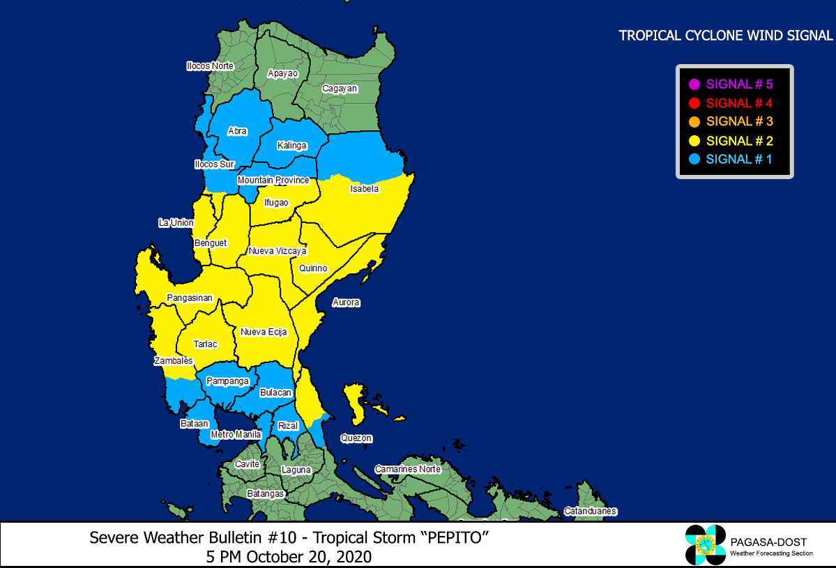
| What Philippine areas will be directly affected? | Heavy to Extreme Rains (50 mm to >100 mm expected in 24 hrs): >> Central Luzon including Metro Manila, Rizal, Northern Quezon, Southern portions of Northern Luzon – Tonight through Tomorrow Morning (Wednesday). Damaging Winds (gusts of more than 100 km/hr expected): |
| Potential Storm Surge/Coastal Flooding Areas+ | :: None.
+Waves of 3 meters in height is expected in storm surge-prone areas, particularly in coastal areas on where the Tropical Cyclone is headed. Kindly visit the PAGASA Storm Surge Updates for more details. |
| 3-Day Forecast Outlook Summary** | WEDNESDAY AFTERNOON: Emerges and intensifies over the West Philippine Sea, just north of Scarborough (Panatag) Shoal…about 203 km W of Alaminos City, Pangasinan [2PM Oct 21: 15.9°N 118.1°E @ 85 kph]. Confidence Level: HIGH
THURSDAY AFTERNOON: Turns NW-ward briefly and exits the western border of the Philippine Area of Responsibility (PAR), becomes a Severe Tropical Storm (STS)…about 430 km WNW of Alaminos City, Pangasinan [2PM Oct 22: 17.2°N 116.1°E @ 100 kph]. Confidence Level: MEDIUM FRIDAY AFTERNOON: Strengthens further as it turns westward across the South China Sea…about 500 km S of Hong Kong, China [2PM Oct 23: 17.9°N 114.1°E @ 110 kph]. Confidence Level: LOW **Important Note: Please be reminded that the Forecast Outlook changes every 6 hours, and the Day 2 and 3 Forecast Track have an average error of 100 and 250 km respectively… while the wind speed forecast error, averages 35 km/hr per day. Therefore, a turn to the left or right of its future track and changes in its wind speed must be anticipated from time to time. |
| Other Storm’s Meteorological Info | > 24 hr. Rain Accumulation (across its circulation): 25 to 200 mm [Light to Heavy]
> Minimum Central Pressure: 996 millibars (hPa) > Size of Circulation [Convective Cloud-Based, in diameter]: 740 km (Medium) > Area of Damaging Winds (100 kph or more wind gusts): None. |
| Current Summary/Additional Reference Points | Time/Date: 5:00 PM PhT Tue October 20, 2020 Location of Center/Eye: Near 15.8°N Lat 122.3°E Lon Distance 1: 129 km SE of Santiago City, Isabela Distance 2: 134 km S of Palanan, Isabela Distance 3: 138 km NNE of Infanta, Quezon Distance 4: 146 km ENE of Cabanatuan City, Nueva Ecija Distance 5: 191 km NE of Metro Manila 24 hr. Forecast Coordinates (Class): 15.9°N 118.1°E (TS) 48 hr. Forecast Coordinates (Class): 17.2°N 116.1°E (STS) 72 hr. Forecast Coordinates (Class): 17.9°N 114.1°E (STS) |
| Information based on data collected by Typhoon2000 (T2k) shall not be taken as official data. Weather information broadcasted and distributed by PAGASA remains as official data. Typhoon2000 (T2k) shall not be responsible for the private use and reliance of its weather information. | |
Issued by: David Michael V. Padua for Typhoon2000 (T2K)
PAGASA TROPICAL CYCLONE WIND SIGNAL
Screenshot/Image Source: DOST-PAGASA (http://pubfiles.pagasa.dost.


