


TROPICAL STORM PEPITO (SAUDEL) ADVISORY NO. 05Issued at: 1:00 PM PhT (05:00 GMT) Tuesday, 20 October 2020
Next update: 7:00 PM PhT (11:00 GMT) Tuesday, 20 October 2020 |
|
|---|---|
| Current Status and Outlook | PEPITO strengthens into a Tropical Storm (TS) while moving faster towards the northern part of Central Luzon…now known internationally as “SAUDEL” – named after a legendary Pohnpei’s Chief Soudelor’s trusted guard or soldier (Contributed by: Federated States of Micronesia). The potential area of landfall of this storm will be somewhere along the east coast of Southern Aurora tonight.
24-hr Outlook: TS PEPITO (SAUDEL) will maintain its strength upon crossing Luzon’s landmass tonight & will intensify further once it emerges over the West Philippine Sea by tomorrow morning. It will therefore move more to the west with a decreased forward speed of 23 km/hr. After making landfall over Aurora tonight, the storm will cross the northern part of Central Luzon passing over Nueva Vizcaya-Nueva Ecija Area, Pangasinan-Tarlac Area between midnight tonight until early tomorrow morning (12 to 6am, Oct 21). The combination of the Pepito’s Rainbands, Trough and the Enhanced Northeasterly & Southwesterly Surface Windflows will bring overcast skies with scattered to widespread “on-&-off” rain showers and thunderstorms across Luzon and Visayas including MiMaRoPa and Sulu Archipelago today and tomorrow. |
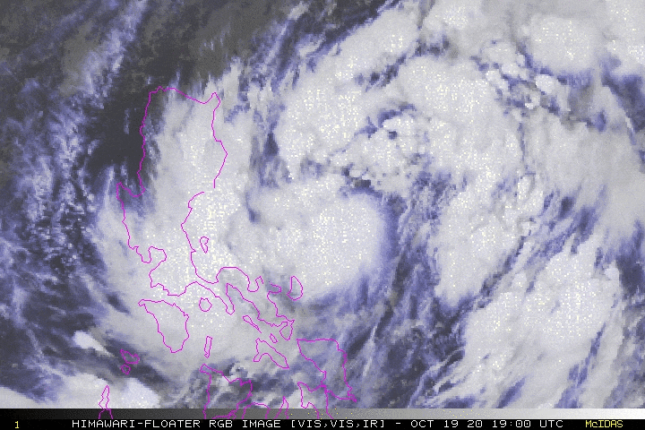
| Where is PEPITO (SAUDEL)? | As of 11:00 AM PhT today, October 20…0300 GMT. The center was located along the northwestern portion of the Central Philippine Sea (near 15.6°N 123.7°E), about 228 km north-northeast of Naga City, Camarines Sur or 225 km east of Baler, Aurora. |
| How strong is it? | Maximum Sustained Winds (1-min avg): 65 kph near the center…Gustiness: 85 kph. |
| Past Movement (06 hrs) | West-Northwest @ 30 kph, towards Northern Part of Central Luzon. |
| Potential Philippine Landfall Area(s) | :: Somewhere along the Coastal Towns of Baler & San Luis, Aurora, between 10 to 11 PM local time Tonight – with Medium Strike Probability of 65%. |
| What Philippine areas will be directly affected? | Heavy to Extreme Rains (50 mm to >100 mm expected in 24 hrs): >> Most Parts of Northern & Central Luzon including Metro Manila & CaLaBaRZon – Today through Tomorrow Morning (Wed). Damaging Winds (gusts of more than 100 km/hr expected): |
| Potential Storm Surge/Coastal Flooding Areas+ | :: None.
+Waves of 3 meters in height is expected in storm surge-prone areas, particularly in coastal areas on where the Tropical Cyclone is headed. Kindly visit the PAGASA Storm Surge Updates for more details. |
| 3-Day Forecast Outlook Summary** | WEDNESDAY MORNING: Emerges and intensifies over the West Philippine Sea, near the coastal waters of Northern Zambales…about 98 km WSW of Alaminos City, Pangasinan [8AM Oct 21: 15.7°N 119.2°E @ 75 kph]. Confidence Level: HIGH
THURSDAY MORNING: Turns WNW-ward and exits the western border of the Philippine Area of Responsibility (PAR), becomes a Severe Tropical Storm (STS)…about 406 km W of Alaminos City, Pangasinan [8AM Oct 22: 16.5°N 116.2°E @ 95 kph]. Confidence Level: HIGH FRIDAY MORNING: Strengthens further while moving westward across the South China Sea…about 612 km W of Alaminos City, Pangasinan [8AM Oct 23: 16.9°N 114.3°E @ 100 kph]. Confidence Level: MEDIUM **Important Note: Please be reminded that the Forecast Outlook changes every 6 hours, and the Day 2 and 3 Forecast Track have an average error of 100 and 250 km respectively… while the wind speed forecast error, averages 35 km/hr per day. Therefore, a turn to the left or right of its future track and changes in its wind speed must be anticipated from time to time. |
| Other Storm’s Meteorological Info | > 24 hr. Rain Accumulation (across its circulation): 25 to 200 mm [Light to Heavy]
> Minimum Central Pressure: 1000 millibars (hPa) > Size of Circulation [Convective Cloud-Based, in diameter]: 825 km (Medium) > Area of Damaging Winds (100 kph or more wind gusts): None. |
| Current Summary/Additional Reference Points | Time/Date: 11:00 AM PhT Tue October 20, 2020 Location of Center/Eye: Near 15.6°N Lat 123.7°E Lon Distance 1: 180 km NNE of Siruma, Camarines Sur Distance 2: 185 km NNE of Daet, Camarines Norte Distance 3: 277 km N of Legazpi City, Albay Distance 4: 184 km ESE of Casiguran, Aurora Distance 5: 306 km ENE of Metro Manila 24 hr. Forecast Coordinates (Class): 15.7°N 119.2°E (TS) 48 hr. Forecast Coordinates (Class): 16.5°N 116.2°E (STS) 72 hr. Forecast Coordinates (Class): 16.9°N 114.3°E (STS) |
| Information based on data collected by Typhoon2000 (T2k) shall not be taken as official data. Weather information broadcasted and distributed by PAGASA remains as official data. Typhoon2000 (T2k) shall not be responsible for the private use and reliance of its weather information. | |
Issued by: David Michael V. Padua for Typhoon2000 (T2K)
PAGASA TROPICAL CYCLONE WIND SIGNAL

Screenshot/Image Source: DOST-PAGASA (http://pubfiles.pagasa.dost.


