
TROPICAL DEPRESSION OFEL ADVISORY NO. 06 (FINAL)Issued at: 7:00 PM PhT (11:00 GMT) Thursday, 15 October 2020
|
|
|---|---|
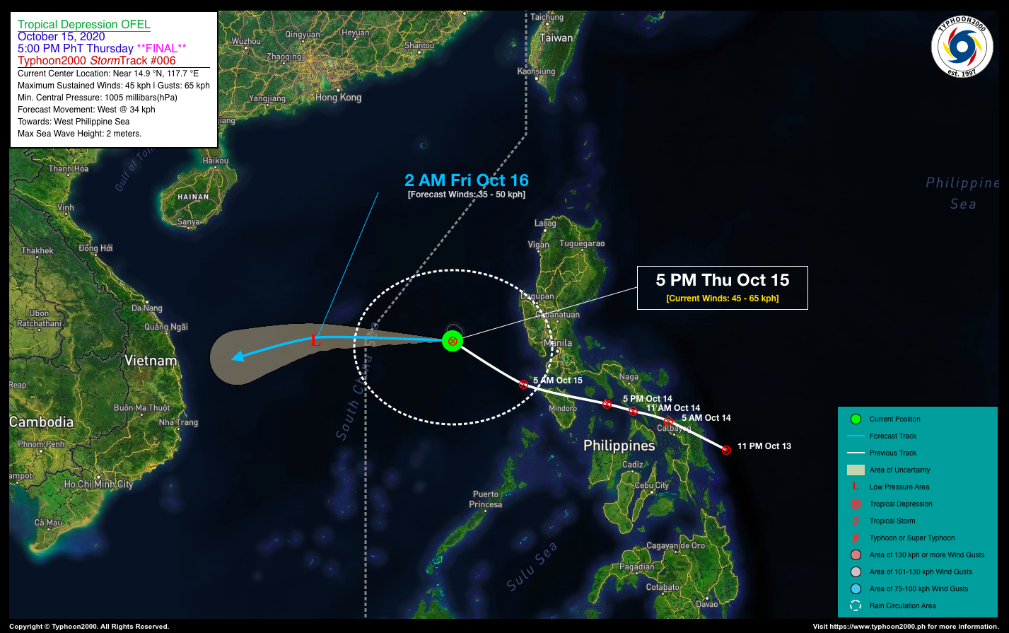
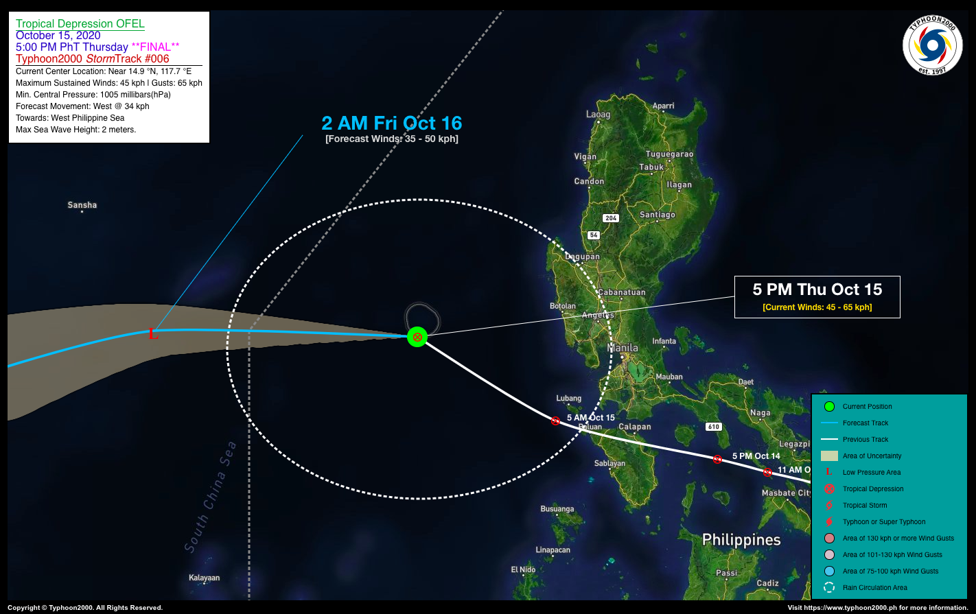
| Current Status and Outlook | Tropical Depression OFEL continues to move across the West Philippine Sea, with no change in its strength…will exit the western border of the Philippine Area of Responsibility (PAR) later tonight.
*This is the Final Advisory on this Tropical Cyclone. 24-hr Outlook: TD OFEL is forecast to weaken into a Low Pressure Area, and shall turn westward at an increased forward speed of 34 km/hr towards the South China Sea. The Trough of this depression will continue bring overcast skies with rain showers and thunderstorms across Central & Southern Luzon including MiMaRoPa today. |
| Where is OFEL? | As of 5:00 PM PhT today, October 15…0900 GMT. The center was located over the Scarborough (Panatag) Shoal (near 14.9°N 117.7°E), about 278 km west of Olongapo City, Zambales or 310 km west-southwest of Dagupan City, Pangasinan. |
| How strong is it? | Maximum Sustained Winds (1-min avg): 45 kph near the center…Gustiness: 65 kph. |
| Past Movement (06 hrs) | West-Northwest @ 24 kph, towards South China Sea. |
| Potential Philippine Landfall Area(s) | :: None. |
| What Philippine areas will be directly affected? | Heavy to Extreme Rains (50 mm to >100 mm expected in 24 hrs): >> None. Damaging Winds (gusts of more than 100 km/hr expected): |
| Potential Storm Surge/Coastal Flooding Areas+ | :: None.
+Waves of 3 meters in height is expected in storm surge-prone areas, particularly in coastal areas on where the Tropical Cyclone is headed. Kindly visit the PAGASA Storm Surge Updates for more details. |
| 1-Day Forecast Outlook Summary** | FRIDAY AFTERNOON: Weakens into a Low Pressure Area (LPA) while moving across the South China Sea, outside of PAR, near the coast of Vietnam…about 948 km SSW of Hong Kong, China [2PM Oct 16: 14.4°N 111.0°E @ 35kph]. Confidence Level: LOW.
**Important Note: Please be reminded that the Forecast Outlook changes every 6 hours, and the Day 2 and 3 Forecast Track have an average error of 100 and 250 km respectively… while the wind speed forecast error, averages 35 km/hr per day. Therefore, a turn to the left or right of its future track and changes in its wind speed must be anticipated from time to time. |
| Other Storm’s Meteorological Info | > 24 hr. Rain Accumulation (across its circulation): 25 to 150 mm [Light to Heavy]
> Minimum Central Pressure: 1005 millibars (hPa) > Size of Circulation [Convective Cloud-Based, in diameter]: 370 km (Very Small/Midget) > Area of Damaging Winds (100 kph or more wind gusts): None. |
| Current Summary/Additional Reference Points | Time/Date: 5:00 PM PhT Thu October 15, 2020 Location of Center/Eye: Near 14.9°N Lat 117.7°E Lon Distance 1: 302 km WSW of San Carlos City, Pangasinan Distance 2: 318 km W of San Fernando City, Pampanga Distance 3: 311 km W of Angeles City, Pampanga Distance 4: 335 km W of Malolos City, Bulacan Distance 5: 363 km W of Metro Manila 24 hr. Forecast Coordinates (Class): 14.4°N 111.0°E (LPA) |
| Information based on data collected by Typhoon2000 (T2k) shall not be taken as official data. Weather information broadcasted and distributed by PAGASA remains as official data. Typhoon2000 (T2k) shall not be responsible for the private use and reliance of its weather information. | |
Issued by: David Michael V. Padua for Typhoon2000 (T2K)


