

TROPICAL DEPRESSION OFEL ADVISORY NO. 05Issued at: 7:00 AM PhT (23:00 GMT) Thursday, 15 October 2020
Next update: 7:00 PM PhT (11:00 GMT) Thursday, 15 October 2020 |
|
|---|---|
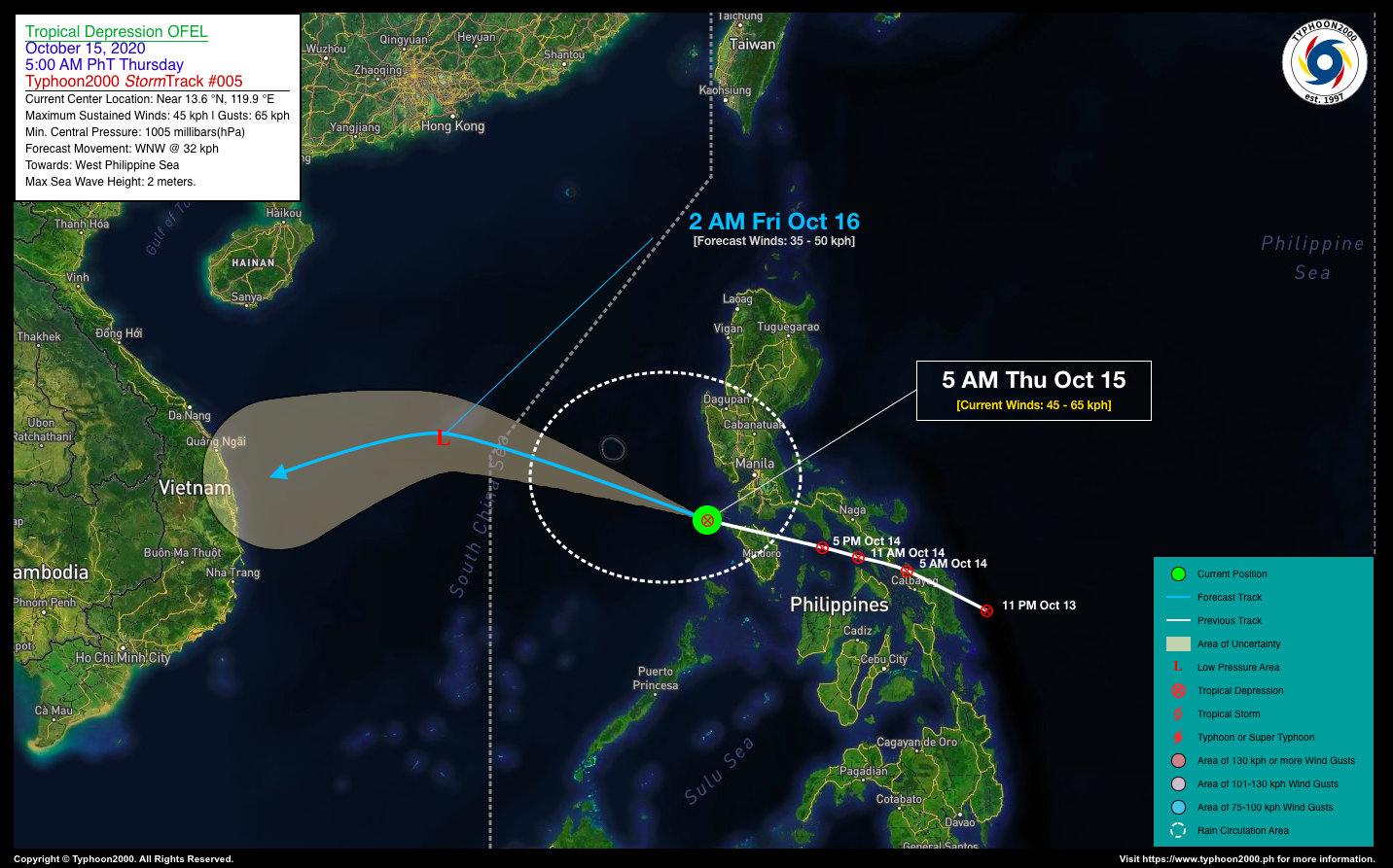
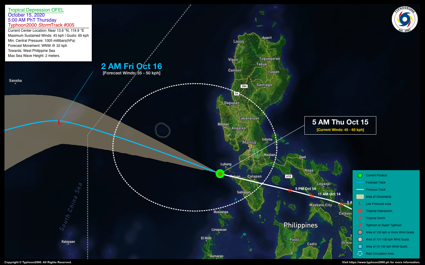
| Current Status and Outlook | Tropical Depression OFEL is now emerging over the West Philippine Sea after crossing Northern Mindoro. Its displaced rainbands continues to dump heavy to intense rainfall across portions of Central and Southern Luzon.
24-hr Outlook: TD OFEL is forecast to maintain its strength with possible weakening into a Low Pressure Area as it moves west-northwestward @ 32 km/hr across the West Philippine Sea. It is then expected to move out of the Philippine Area of Responsibility (PAR) late this evening or early tomorrow morning (Oct 16). The Trough of this depression will continue bring overcast skies with rain showers and thunderstorms across much of Luzon and MiMaRoPa. |
| Where is OFEL? | As of 5:00 AM PhT today, October 15…2100 GMT. The center was located over the southwestern coastal waters of Lubang Island (near 13.6°N 119.9°E), about 126 km west of Batangas City, Batangas or 165 km southwest of Metro Manila. |
| How strong is it? | Maximum Sustained Winds (1-min avg): 45 kph near the center…Gustiness: 65 kph. |
| Past Movement (06 hrs) | West-Northwest @ 37 kph, towards West Philippine & South China Seas. |
| Potential Philippine Landfall Area(s) | :: None. |
| What Philippine areas will be directly affected? | Heavy to Extreme Rains (50 mm to >100 mm expected in 24 hrs): >> Parts of Central Luzon – Today. Damaging Winds (gusts of more than 100 km/hr expected): |
| Potential Storm Surge/Coastal Flooding Areas+ | :: None.
+Waves of 3 meters in height is expected in storm surge-prone areas, particularly in coastal areas on where the Tropical Cyclone is headed. Kindly visit the PAGASA Storm Surge Updates for more details. |
| 1-Day Forecast Outlook Summary** | FRIDAY EARLY MORNING: Exits PAR as it decays into a Low Pressure Area (LPA) while moving across the South China Sea…about 644 km W of Alaminos City, Pangasinan [2AM Oct 16: 15.5°N 114.0°E @ 35kph]. Confidence Level: LOW.
**Important Note: Please be reminded that the Forecast Outlook changes every 6 hours, and the Day 2 and 3 Forecast Track have an average error of 100 and 250 km respectively… while the wind speed forecast error, averages 35 km/hr per day. Therefore, a turn to the left or right of its future track and changes in its wind speed must be anticipated from time to time. |
| Other Storm’s Meteorological Info | > 24 hr. Rain Accumulation (across its circulation): 25 to 200 mm [Light to Heavy]
> Minimum Central Pressure: 1005 millibars (hPa) > Size of Circulation [Convective Cloud-Based, in diameter]: 355 km (Very Small/Midget) > Area of Damaging Winds (100 kph or more wind gusts): None. |
| Current Summary/Additional Reference Points | Time/Date: 5:00 AM PhT Thu October 15, 2020 Location of Center/Eye: Near 13.6°N Lat 119.9°E Lon Distance 1: 139 km S of Calapan City, Oriental Mindoro Distance 2: 144 km SSW of Olongapo City, Zambales Distance 3: 145 km WSW of Tanauan City, Batangas Distance 4: 129 km SW of Trece Martires City, Cavite Distance 5: 148 km WSW of Calamba City, Laguna 24 hr. Forecast Coordinates (Class): 15.5°N 114.0°E (LPA) |
| Information based on data collected by Typhoon2000 (T2k) shall not be taken as official data. Weather information broadcasted and distributed by PAGASA remains as official data. Typhoon2000 (T2k) shall not be responsible for the private use and reliance of its weather information. | |
Issued by: David Michael V. Padua for Typhoon2000 (T2K)
PAGASA TROPICAL CYCLONE WIND SIGNAL
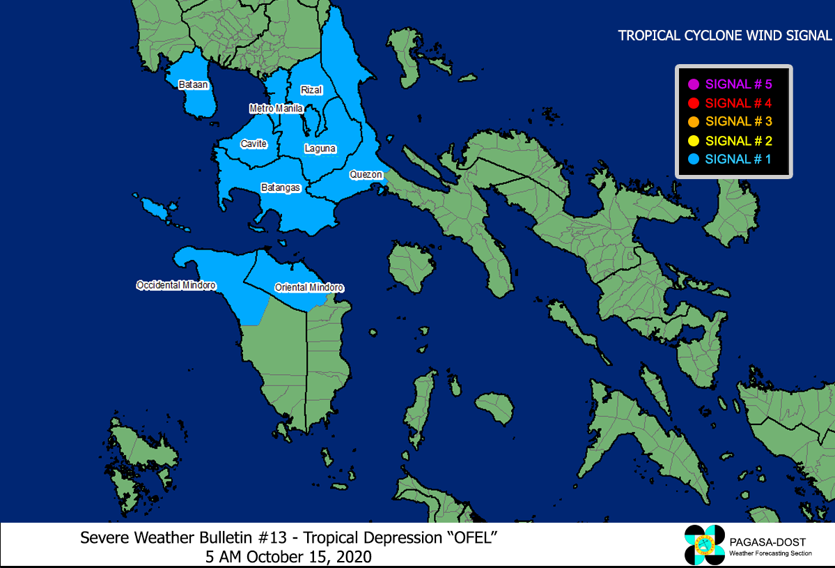
Image Source: DOST-PAGASA (http://pubfiles.pagasa.dost.


