
TROPICAL DEPRESSION OFEL ADVISORY NO. 02Issued at: 7:00 AM PhT (23:00 GMT) Wednesday, 14 October 2020
Next update: 1:00 PM PhT (05:00 GMT) Wednesday, 14 October 2020 |
|
|---|---|
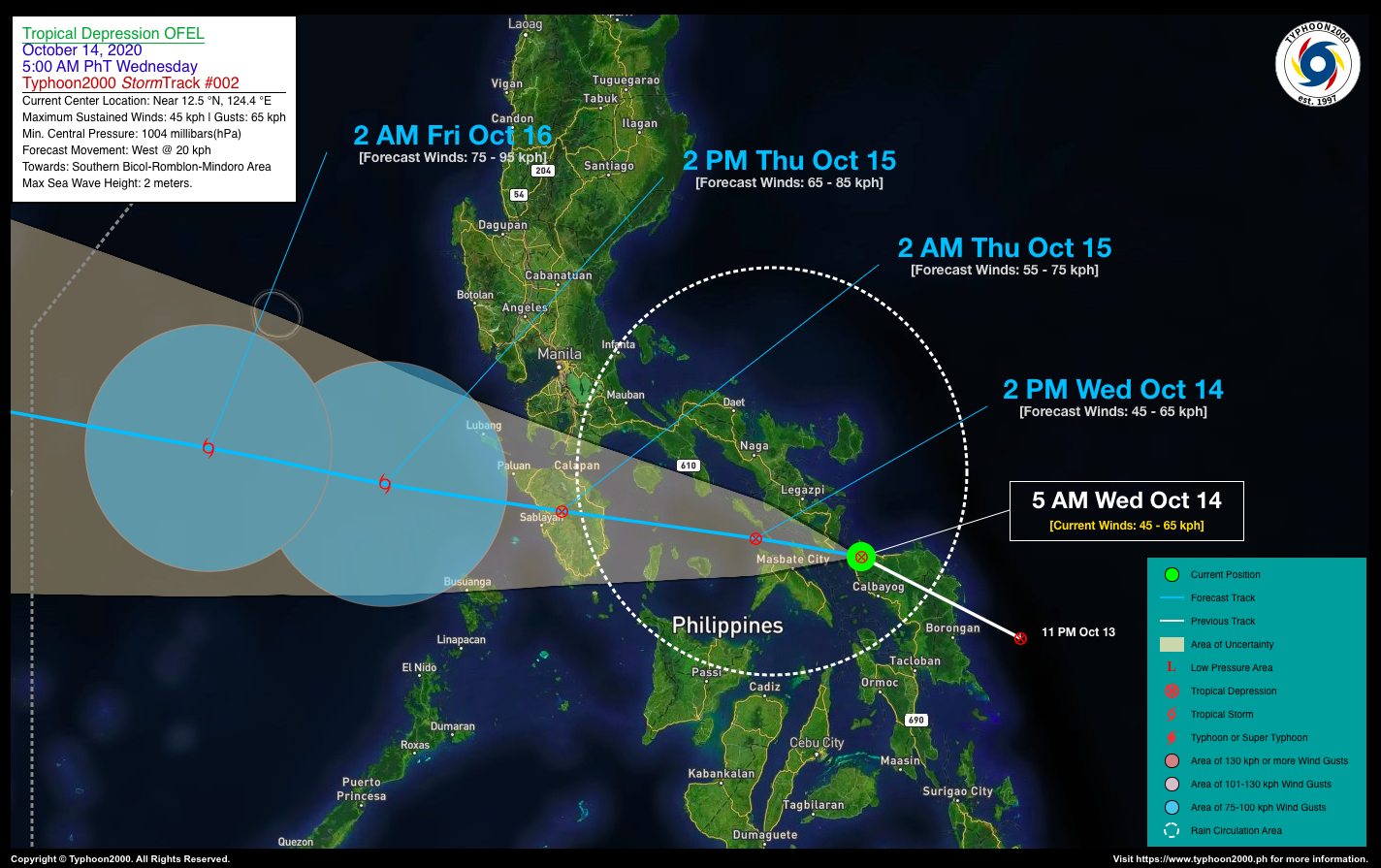
| Current Status and Outlook | Tropical Depression OFEL has rapidly accelerated and made landfall over Eastern Samar early this morning…now in the vicinity of Rosario, Northern Samar…expected to traverse the Southern Tip of Sorsogon, Ticao and Burias Islands for the next 6-8 hours. Its displaced thick Rainbands are currently spreading across the whole Bicol Region.
24-hr Outlook: TD OFEL is forecast to intensify slightly as it moves westward along the southern part of Ragay Gulf and Sibuyan Sea today, passing over the northern Romblon Islands of Bantan and Corcuera later tonight. It is then expected to make landfall over Oriental Mindoro around midnight or early Thursday morning (Oct 15). The trough of this depression will continue bring overcast skies with rain showers and thunderstorms across Visayas, Northeastern Mindanao, and the rest of Southern & Central Luzon including Metro Manila today. |
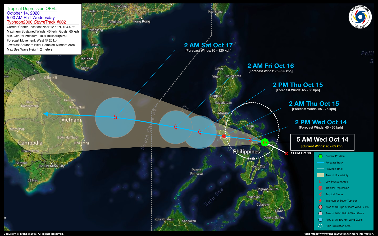
| Where is OFEL? | As of 5:00 AM PhT today, October 14…2100 GMT. The center was located over Rosario, Northern Samar (near 12.5°N 124.4°E), about 28 km west-northwest of Catarman, Northern Samar or 69 km southeast of Sorsogon City, Sorsogon. |
| How strong is it? | Maximum Sustained Winds (1-min avg): 45 kph near the center…Gustiness: 65 kph. |
| Past Movement (06 hrs) | West-Northwest @ 37 kph, towards Southern Bicol-Romblon-Mindoro Area. |
| Potential Philippine Landfall Area(s) | :: Landfall 2 – Along the southern tip of Sorsogon, between 6 to 7 AM Today – with High Strike Probability of 80%.
:: Landfall 3 – Somewhere along the towns of Pinamalayan-Gloria-Bansud, Oriental Mindoro, between 11 PM tonight to 12 AM local time tomorrow, Thursday (Oct 15) – with High Strike Probability of 65%. |
| What Philippine areas will be directly affected? | Heavy to Extreme Rains (50 mm to >100 mm expected in 24 hrs): >> Bicol Region, Southern Quezon, Romblon, Marinduque, Southern Luzon, Mindoro, Metro Manila, Portions of Central Luzon – Today. Damaging Winds (gusts of more than 100 km/hr expected): |
| Potential Storm Surge/Coastal Flooding Areas+ | :: None.
+Waves of 3 meters in height is expected in storm surge-prone areas, particularly in coastal areas on where the Tropical Cyclone is headed. Kindly visit the PAGASA Storm Surge Updates for more details. |
| 2-Day Forecast Outlook Summary** | THURSDAY EARLY MORNING: Over the northern edges of Mt. Baco, Occidental Mindoro, approaching the Town of Santa Cruz…about 46 km SSW of Calapan City, Oriental Mindoro [2AM Oct 15: 13.0°N 121.0°E @ 55kph]. Confidence Level: MEDIUM.
FRIDAY EARLY MORNING: Intensifies into a Tropical Storm (TS) as it moves across the West Philippine Sea…about 376 km WSW of Olongapo City, Zambales [2AM Oct 16: 13.7°N 117.0°E @ 75kph]. Confidence Level: MEDIUM. **Important Note: Please be reminded that the Forecast Outlook changes every 6 hours, and the Day 2 and 3 Forecast Track have an average error of 100 and 250 km respectively… while the wind speed forecast error, averages 35 km/hr per day. Therefore, a turn to the left or right of its future track and changes in its wind speed must be anticipated from time to time. |
| Other Storm’s Meteorological Info | > 24 hr. Rain Accumulation (across its circulation): 25 to 200 mm [Light to Heavy]
> Minimum Central Pressure: 1004 millibars (hPa) > Size of Circulation [Convective Cloud-Based, in diameter]: 470 km (Small) > Area of Damaging Winds (100 kph or more wind gusts): None. |
| Current Summary/Additional Reference Points | Time/Date: 5:00 AM PhT Wed October 14, 2020 Location of Center/Eye: Near 12.5°N Lat 124.4°E Lon Distance 1: 94 km E of Masbate City, Masbate Distance 2: 123 km SE of Ligao City, Albay Distance 3: 123 km S of Bato, Catanduanes Distance 4: 178 km SE of Naga City, Camarines Sur Distance 5: 428 km ESE of Metro Manila 24 hr. Forecast Coordinates (Class): 13.0°N 121.0°E (TD) 48 hr. Forecast Coordinates (Class): 13.7°N 117.0°E (TS) |
| Information based on data collected by Typhoon2000 (T2k) shall not be taken as official data. Weather information broadcasted and distributed by PAGASA remains as official data. Typhoon2000 (T2k) shall not be responsible for the private use and reliance of its weather information. | |
Issued by: David Michael V. Padua for Typhoon2000 (T2K)
PAGASA TROPICAL CYCLONE WIND SIGNAL
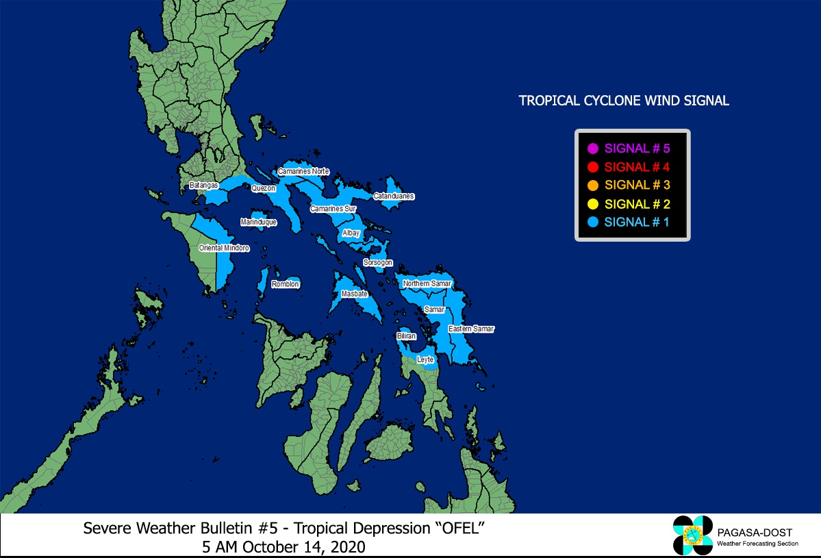
Image Source: DOST-PAGASA (http://pubfiles.pagasa.dost.


