

TROPICAL DEPRESSION OFEL ADVISORY NO. 01Issued at: 8:00 PM PhT (12:00 GMT) Tuesday, 13 October 2020
Next update: 7:00 AM PhT (23:00 GMT) Wednesday, 14 October 2020 |
|
|---|---|
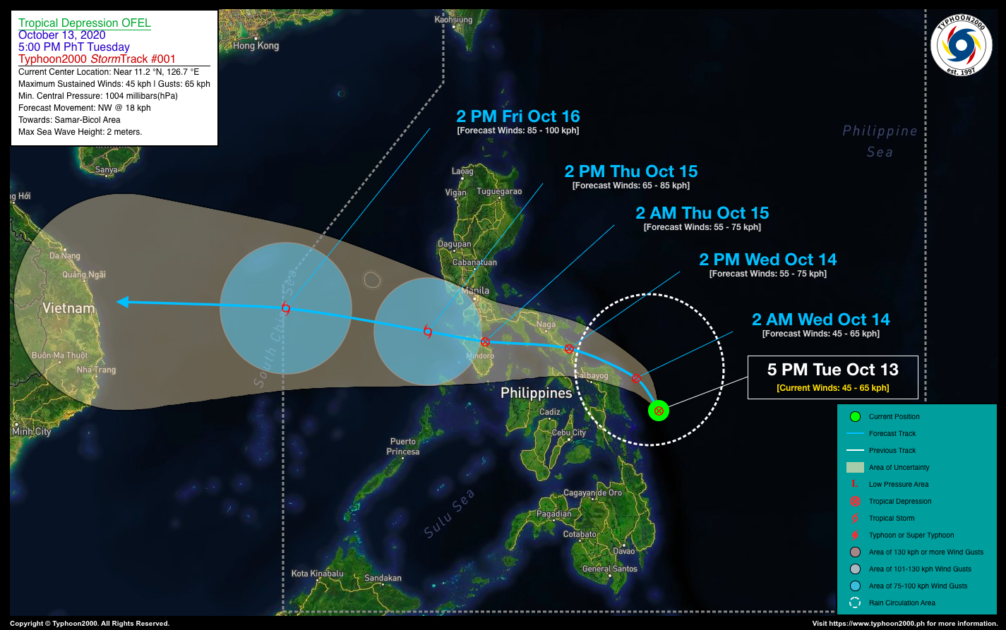
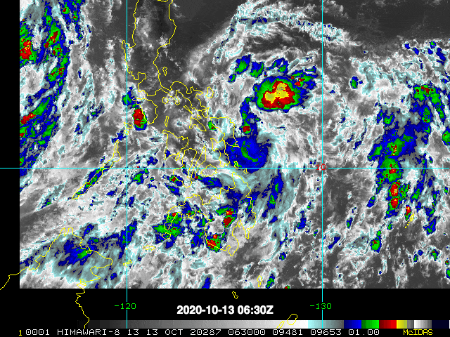
| Current Status and Outlook | Tropical Depression OFEL newly-formed over the Central Philippine Sea, near the coast of Eastern Samar…its rainbands will now bring occasional rains and gusty winds along Eastern Visayas and Bicol Region tonight through tomorrow.
24-hr Outlook: TD OFEL is forecast to intensify slightly as it moves along the coastal areas of Eastern & Northern Samar tonight and will move northwest to west-northwestward with an increased forward speed of 18 km/hr towards Northern Samar & Southern Bicol. It is then expected to make landfall over the northeastern portion of Northern Samar by tomorrow morning, and make another landfall over Sorsogon-Albay Area tomorrow noon or afternoon (Oct 14). The trough of this depression will bring overcast skies with rain showers and thunderstorms across Visayas, Northeastern Mindanao, and the rest of Southern & Central Luzon including Metro Manila tomorrow (Oct 14). |
| Where is OFEL? | As of 5:00 PM PhT today, October 13…0900 GMT. The center was located along the southwestern portion of the Central Philippine Sea (near 11.2°N 126.7°E), about 108 km east of Guiuan, Eastern Samar or 190 km east of Tacloban City, Leyte. |
| How strong is it? | Maximum Sustained Winds (1-min avg): 45 kph near the center…Gustiness: 65 kph. |
| Past Movement (06 hrs) | West slowly, towards Samar-Bicol Area. |
| Potential Philippine Landfall Area(s) | :: Landfall 1 – Along the northeastern coast of Eastern or Northern Samar, between 6 to 8 AM Wednesday local time (Oct 14) – with Medium Strike Probability of 50%.
:: Landfall 2 – Along Sorsogon-Albay Area, between 12 PM to 2 PM local time on Wednesday (Oct 14) – with Medium Strike Probability of 40%. |
| What Philippine areas will be directly affected? | Heavy to Extreme Rains (50 mm to >100 mm expected in 24 hrs): >> Bicol Region & Samar Provinces – Tonight through Wednesday (Oct 14). Damaging Winds (gusts of more than 100 km/hr expected): |
| Potential Storm Surge/Coastal Flooding Areas+ | :: None.
+Waves of 3 meters in height is expected in storm surge-prone areas, particularly in coastal areas on where the Tropical Cyclone is headed. Kindly visit the PAGASA Storm Surge Updates for more details. |
| 2-Day Forecast Outlook Summary** | WEDNESDAY AFTERNOON: Strengthens slightly as it traverses Sorsogon-Albay Area…about 17 km ESE of Legazpi City, Albay [2PM Oct 14: 13.1°N 123.9°E @ 55kph]. Confidence Level: MEDIUM.
THURSDAY AFTERNOON: Intensifies into a Tropical Storm (TS) as it emerges over the West Philippine Sea…about 162 km SW of Balanga, Bataan [2PM Oct 15: 13.6°N 119.5°E @ 65kph]. Confidence Level: LOW. **Important Note: Please be reminded that the Forecast Outlook changes every 6 hours, and the Day 2 and 3 Forecast Track have an average error of 100 and 250 km respectively… while the wind speed forecast error, averages 35 km/hr per day. Therefore, a turn to the left or right of its future track and changes in its wind speed must be anticipated from time to time. |
| Other Storm’s Meteorological Info | > 24 hr. Rain Accumulation (across its circulation): 25 to 200 mm [Light to Heavy]
> Minimum Central Pressure: 1004 millibars (hPa) > Size of Circulation [Convective Cloud-Based, in diameter]: 625 km (Small) > Area of Damaging Winds (100 kph or more wind gusts): None. |
| Current Summary/Additional Reference Points | Time/Date: 5:00 PM PhT Tue October 13, 2020 Location of Center/Eye: Near 11.2°N Lat 126.7°E Lon Distance 1: 211 km ENE of Baybay City, Leyte Distance 2: 228 km E of Ormoc City, Leyte Distance 3: 262 km ESE of Catarman, Northern Samar Distance 4: 464 km SE of Naga City, Camarines Sur Distance 5: 717 km ESE of Metro Manila 24 hr. Forecast Coordinates (Class): 13.1°N 123.9°E (TD) 48 hr. Forecast Coordinates (Class): 13.6°N 119.5°E (TS) |
| Information based on data collected by Typhoon2000 (T2k) shall not be taken as official data. Weather information broadcasted and distributed by PAGASA remains as official data. Typhoon2000 (T2k) shall not be responsible for the private use and reliance of its weather information. | |
Issued by: David Michael V. Padua for Typhoon2000 (T2K)
PAGASA TROPICAL CYCLONE WIND SIGNAL
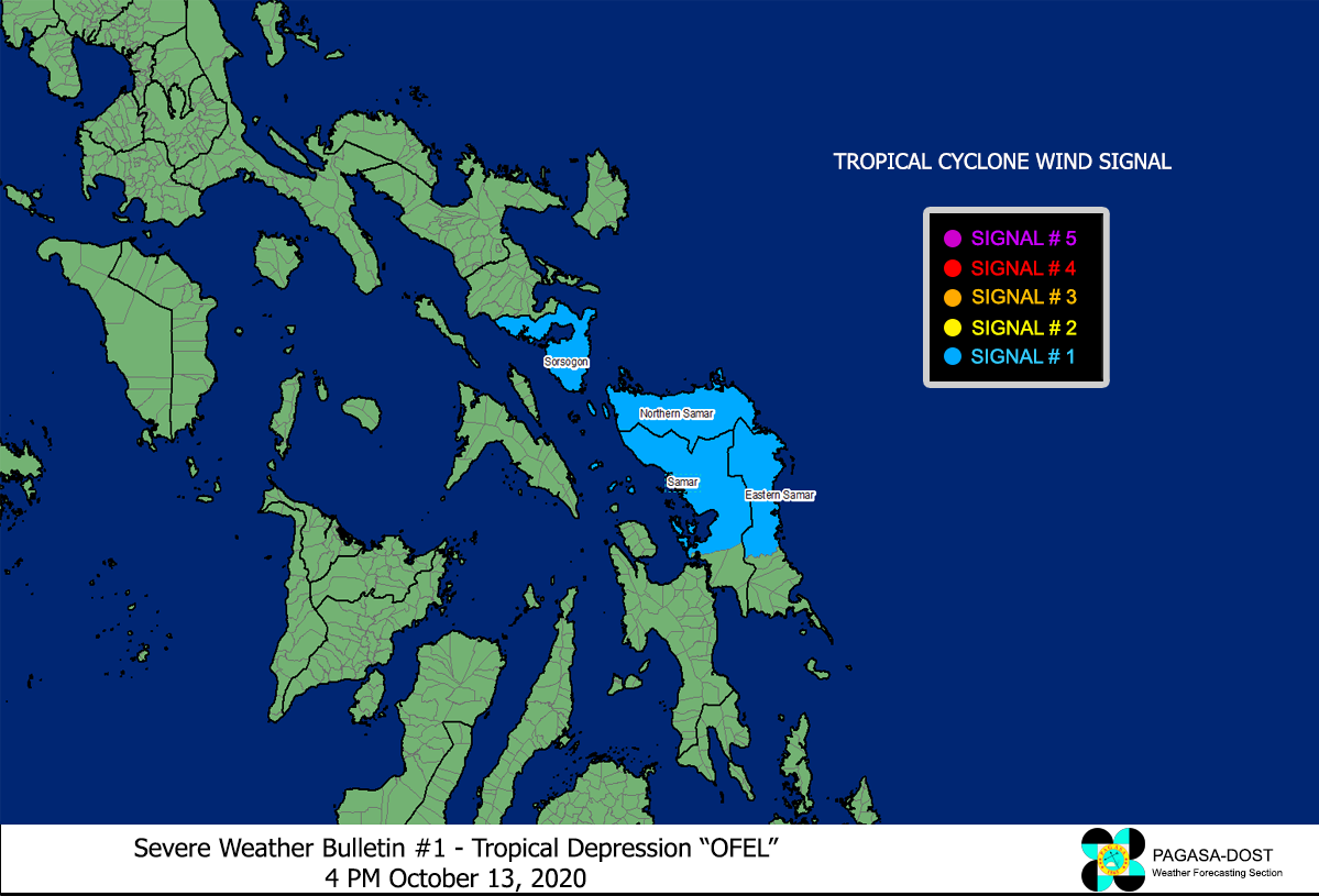
Image Source: DOST-PAGASA (http://pubfiles.pagasa.dost.


