TYPHOON ODETTE (RAI) ADVISORY NO. 04

Issued at: 7:00 AM PhT (23:00 GMT) Thursday, 16 December 2021
Next update: 1:00 PM PhT (05:00 GMT) Thursday, 16 December 2021
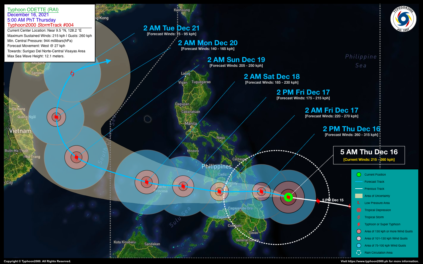
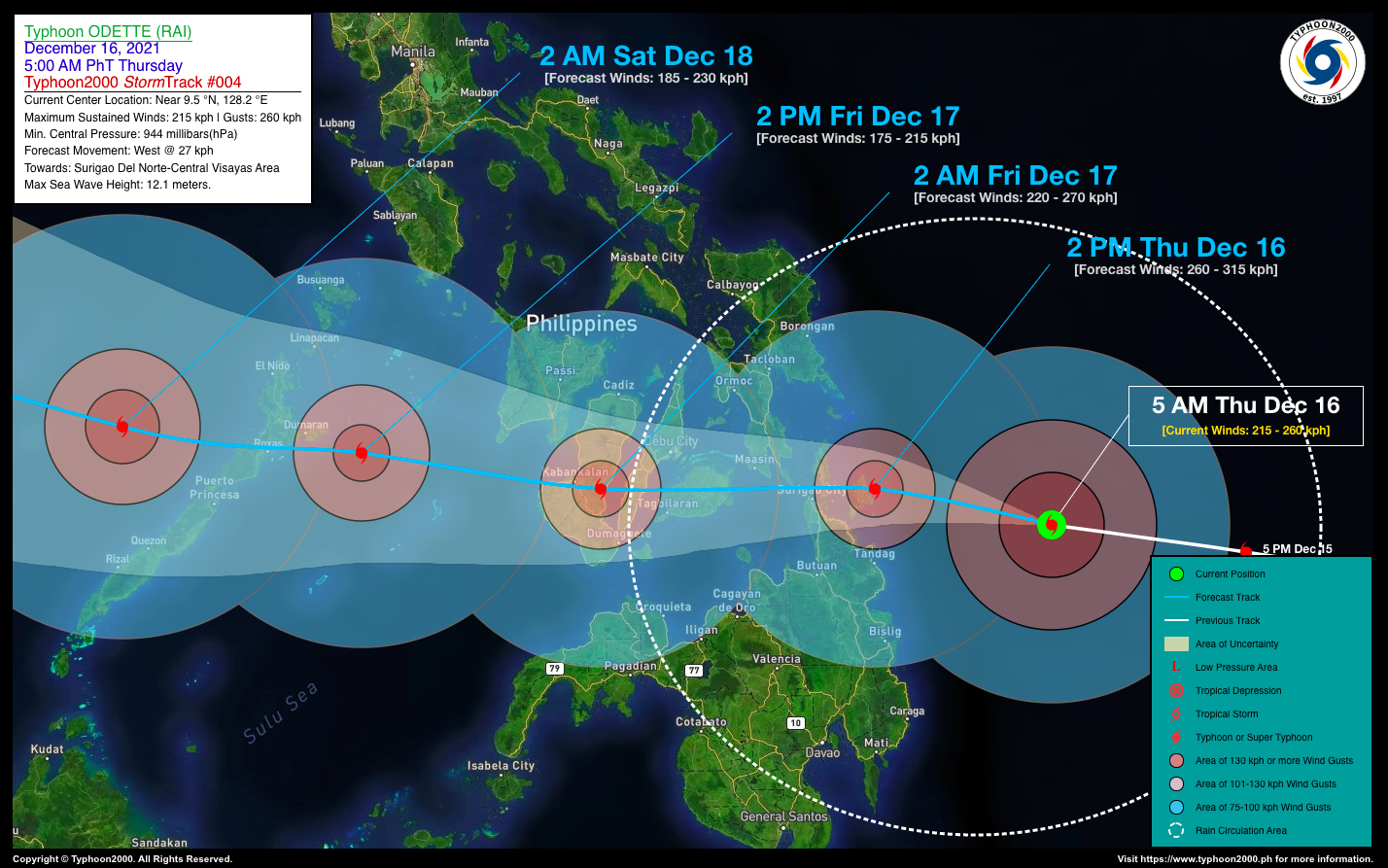
Current Status & Outlook Typhoon ODETTE (RAI) has rapidly intensified into a 215-km/hr Category 4 system as it moves closer to Northern Caraga, particularly the islands of Siargao and Dinagat Islands. This system could become a Super Typhoon if the rapid intensification trend continues to occur prior to landfall.

24-hr Outlook: TY ODETTE (RAI) is forecast to accelerate westward at an increased speed of 27 kph, making landfall along Siargao-Dinagat-Surigao Del Norte this afternoon with forecast winds of 260 kph, and will start to cross the Visayas passing over Bohol tonight, and over Cebu around midnight. By early tomorrow morning, Odette will traverse Southern or Central Negros with decreased wind speeds of 220 kph (Cat 4).

The presence of this powerful typhoon will enhance the Northeast Monsoon (Amihan) and bring cloudy skies with passing “on-and-off” rains with possible Severe Thunderstorms and gusty winds of 30-60 kph across the Eastern Sections of Northern & Central Luzon including CaLaBaRZon, Metro Manila, Bicol Region, Oriental Mindoro, & Marinduque – beginning today through Friday (Dec 17).

Where is ODETTE (RAI)? As of 5:00 AM PhT today, December 16…2100 GMT:

  • Location of Center/Eye: Along the northwestern part of the South Philippine Sea (near 9.5°N 128.2°E)
  • Distance 1: 240 km east of Siargao Island, Surigao Del Norte
  • Distance 2: 296 km east of Surigao City, Surigao Del Norte
  • Distance 3: 482 km east of Cebu City, Cebu
How strong is it? Maximum Sustained Winds (1-min avg): 215 kph near the center…Gustiness: 260 kph.
Past Movement (06 hrs) West @ 20 kph, across the Philippine Sea.
Potential Philippine Major Landfall Area(s)
  • Landfall 01:  Over Siargao-Dinagat Islands, between 2 to 4 PM Today – with High Strike Probability of >90%. 
  • Landfall 02:  Over Surigao Del Norte, between 4 to 6 PM Today – with High Strike Probability of >90%.
  • Landfall 03:  Over Bohol between 8 to 11 PM Today – with High Strike Probability of >90%.
  • Landfall 04:  Over Southern-Central Cebu Area, between 12 to 2 AM Tomorrow, Dec 17 – with High Strike Probability of >90%.
  • Landfall 05:  Over Central-Southern Negros Area, between 2 to 6 AM Tomorrow, Dec 17 – with High Strike Probability of >90%.
  • Landfall 06:  Over Northern Palawan, between 5 to 9 PM Tomorrow, Dec 17 – with High Strike Probability of >90%.
What Philippine areas will be directly affected? Heavy to Extreme Rainfall (50 mm to >100 mm expected for 24 hrs):

  • Visayas, Romblon, Bicol Region, Northern Mindanao, Caraga, Zamboanga Del Norte – beginning Today until Friday Evening (Dec 17).
  • Mindoro, Palawan, Sulu Archipelago – beginning Friday (Dec 17) until Saturday Morning (Dec 18).

Damaging Winds (gusts of more than 100 km/hr expected):

  • Surigao Del Norte, Siargao, Dinagat, Southern Leyte – beginning this afternoon until tonight.
  • Bohol, Cebu, Negros, & Southern Panay – beginning late tonight until Fri Noon (Dec 17).
  • Cuyo-Pamalican Area – beginning Friday Morning until Early Evening (Dec 17).
  • Northern Palawan – beginning Friday Afternoon (Dec 17) until Early Saturday Morning (Dec 18).
Potential Storm Surge/Coastal Flooding Areas+
  • Coastal & Beachfront Areas of Eastern and Northern Mindanao, Visayas, Sulu Archipelago, Southern Bicol, & MiMaRoPa.

+Waves of 3 to 6 meters in height are expected in storm surge-prone areas, particularly in coastal areas where the Tropical Cyclone is headedKindly visit the PAGASA Storm Surge Updates  for more details.

3-Day Forecast Outlook Summary**
  • THURSDAY AFTERNOON: Just along the east coast of Siargao Island as it intensifies into a Catastrophic Category 5 Super Typhoon…about 77 km ENE of Surigao City, Surigao Del Norte [2PM Dec 16: 9.9°N 126.2°E @ 260 kph]Forecast ConfidenceHIGH
  • FRIDAY EARLY MORNING: Making landfall over Ayungon-Tayasan Area, Negros Oriental, weakens to a Category 4 Typhoon…about 27 km E of Kabankalan City, Negros Occidental [2AM Dec 17: 9.9°N 123.1°E @ 220 kph]Forecast Confidence: HIGH
  • FRIDAY AFTERNOON: Over Sulu Sea, approaching Northern Palawan. Weakens further to Category 2…about 181 km ENE of Puerto Princesa City, Palawan [2PM Dec 17: 10.3°N 120.4°E @ 175 kph]Forecast Confidence: HIGH
  • SATURDAY EARLY MORNING: Emerges over the West Philippine Sea after crossing Northern Palawan, strengthens back to Category 3…about 138 km WNW of Puerto Princesa City, Palawan [2AM Dec 18: 10.6°N 117.7°E @ 185 kph]Forecast Confidence: HIGH
  • SUNDAY EARLY MORNING: Already outside of the Philippine Area of Responsibility (PAR) as it continues to re-intensify just to the east of Vietnam or over the South China Sea…about 737 km WNW of Puerto Princesa City, Palawan [2AM Dec 19: 12.4°N 112.5°E @ 205 kph]Forecast Confidence: HIGH

**Important Note: Please be reminded that the Forecast Outlook changes every 6 hours, and the Day 2 and 3 Forecast Track have an average error of 100 and 250 km respectively… while the wind speed forecast error, averages 35 km/hr per day. Therefore, a turn to the left or right of its future track and changes in its wind speed must be anticipated from time to time.

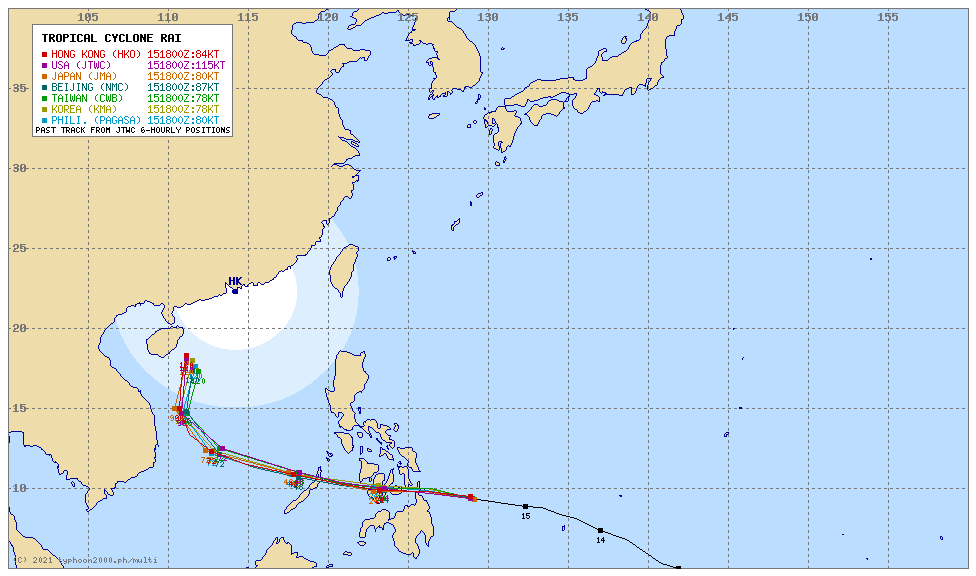
Other Storm’s Meteorological Information
  • 24-hr. Rain Accumulation (across its circulation): 25 to 500 mm [Light to Extreme]
  • Minimum Central Pressure: 944 millibars (hPa)
  • Size of Rain Circulation (in Diameter): Average (870 km)
  • Size of Wind Circulation (55-kph Wind Diameter): Average (720 km)
  • Area of Damaging Winds (100 kph or more wind gusts): 160 km outward from the center
Information based on data collected by Typhoon2000 (T2k) shall not be taken as official data. Weather information broadcasted and distributed by PAGASA remains as official data. Typhoon2000 (T2k) shall not be responsible for the private use and reliance of its weather information.

Issued by: David Michael V. Padua for Typhoon2000 (T2K)

o

Typhoon2000 (T2K) Integrated Multi-Agency Tracks

o

PAGASA TROPICAL CYCLONE WIND SIGNAL


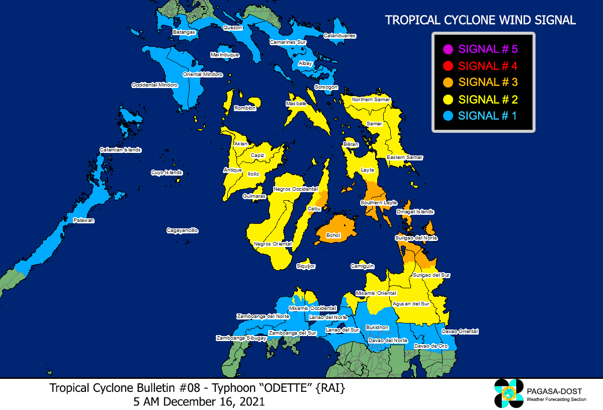
Image/Screenshot Source: DOST-PAGASA (http://bagong.pagasa.dost.gov.ph/tropical-cyclone-bulletin-iframe)

CONTACT US

We're not around right now. But you can send us an email and we'll get back to you, asap.

Sending

©2024 Typhoon2000.

Log in with your credentials

Forgot your details?