SUPER TYPHOON ODETTE (RAI) ADVISORY NO. 05

Issued at: 1:00 PM PhT (05:00 GMT) Thursday, 16 December 2021
Next update: 7:00 PM PhT (11:00 GMT) Thursday, 16 December 2021
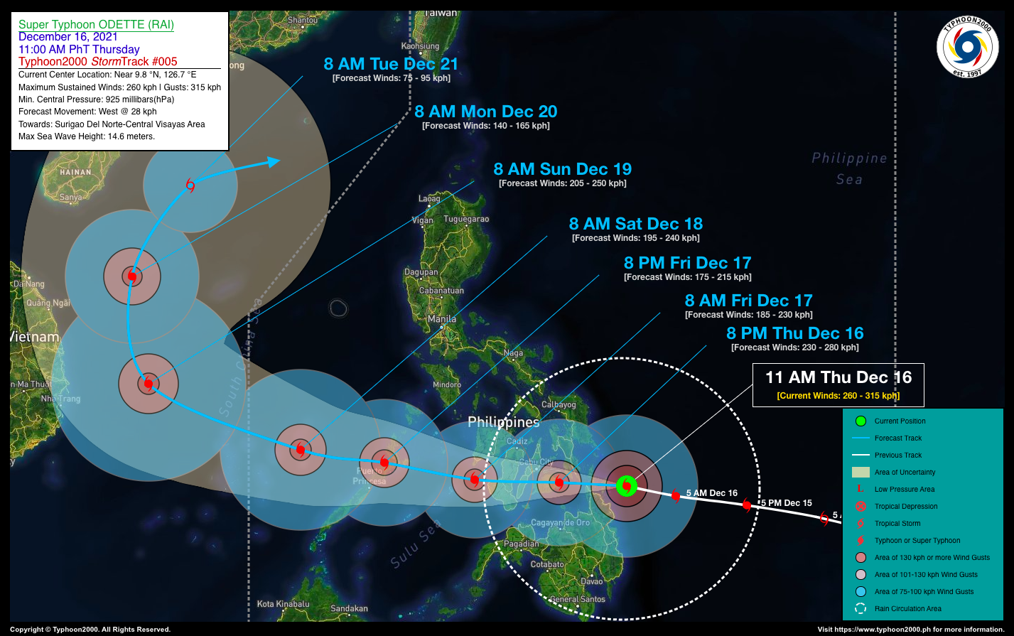
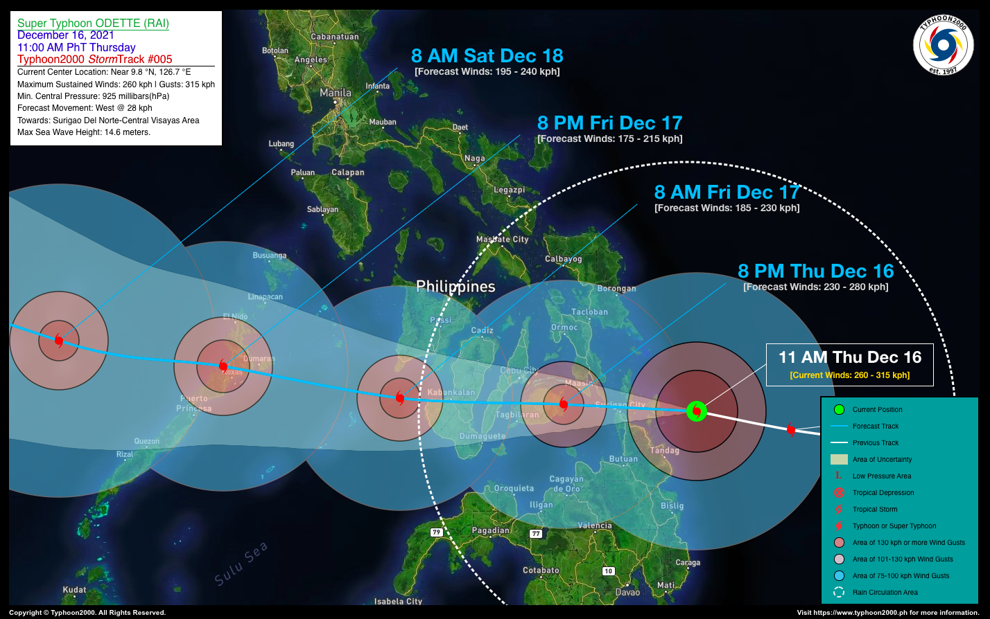
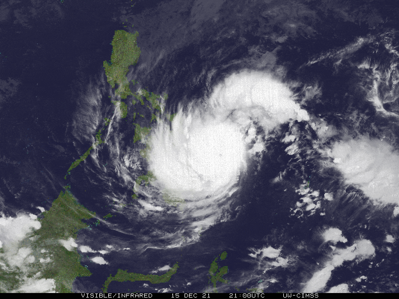
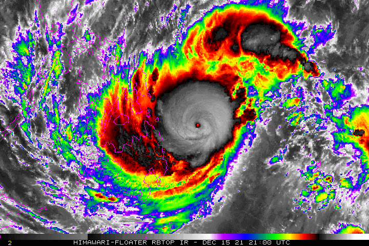
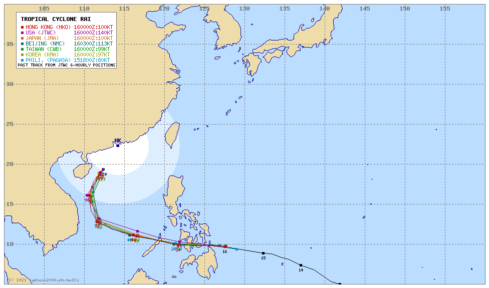
Current Status & Outlook ODETTE (RAI) is now an Extremely Catastrophic, Category 5 Super Typhoon after undergoing rapid intensification during the past 6 to 12 hours. The Core (Eye+Eyewall) is about to make landfall over Siargao-Dinagat Islands in the next few hours.

24-hr Outlook: STY ODETTE (RAI) is forecast to accelerate west to west-northwestward at an increased speed of 28 kph, making further multiple landfalls across Surigao Del Norte (this afternoon), Bohol (tonight), Cebu (late tonight or midnight), Negros (early tomorrow morning) and will be over the Sulu Sea by mid-morning tomorrow. The intensity of Odette will start to weaken from 260 kph down to 185 kph (Category 3) upon moving over the Sulu Sea.

The presence of this powerful typhoon will enhance the Northeast Monsoon (Amihan) and bring cloudy skies with passing “on-and-off” rains with possible Severe Thunderstorms and gusty winds of 30-60 kph across the Eastern Sections of Northern & Central Luzon including CaLaBaRZon, Metro Manila, Bicol Region, Oriental Mindoro, & Marinduque – today through Friday (Dec 17).

Where is ODETTE (RAI)? As of 11:00 AM PhT today, December 16…0300 GMT:

  • Location of Center/Eye: Approaching the eastern shoreline of Siargao Island (near 9.8°N 126.7°E)
  • Distance 1: 72 km east of Siargao Island, Surigao Del Norte
  • Distance 2: 130 km east of Surigao City, Surigao Del Norte
  • Distance 3: 208 km east of Maasin City, Southern Leyte
How strong is it? Maximum Sustained Winds (1-min avg): 260 kph near the center…Gustiness: 315 kph.
Past Movement (06 hrs) West @ 26 kph, towards Surigao Del Norte-Bohol-Cebu-Negros Area.
Potential Philippine Major Landfall Area(s)
  • Landfall 01:  Over Siargao-Dinagat Islands, between 1 to 3 PM Today – with High Strike Probability of >90%. 
  • Landfall 02:  Over Southern Leyte (Panaon Is.) between 3 to 5 PM Today – with High Strike Probability of >90%.
  • Landfall 03:  Over Bohol between 7 to 10 PM Today – with High Strike Probability of >90%.
  • Landfall 04:  Over Southern-Central Cebu Area, between 11 PM Today to 1 AM Tomorrow, Dec 17 – with High Strike Probability of >90%.
  • Landfall 05:  Over Central-Southern Negros Area, between 1 to 5 AM Tomorrow, Dec 17 – with High Strike Probability of >90%.
  • Landfall 06:  Over Northern Palawan, between 5 to 9 PM Tomorrow, Dec 17 – with High Strike Probability of >90%.
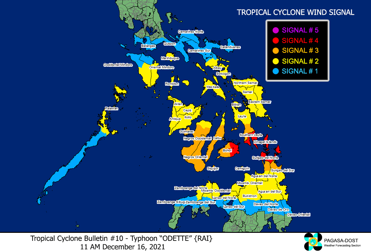
What Philippine areas will be directly affected? Heavy to Extreme Rainfall (50 mm to >100 mm expected for 24 hrs):

  • Visayas, Romblon, Bicol Region, Northern Mindanao, Caraga, Zamboanga Del Norte – Today until Friday Evening (Dec 17).
  • Mindoro, Palawan, Sulu Archipelago – beginning tomorrow until Saturday Morning (Dec 18).

Damaging Winds (gusts of more than 100 km/hr expected):

  • Agusan Del Norte, Misamis Oriental, Camiguin Island, Surigao Provinces, Siargao, Dinagat, Southern Leyte – this afternoon until tonight.
  • Bohol, Cebu, Negros, & Southern Panay – beginning tonight until tomorrow morning (Dec 17).
  • Cuyo-Pamalican Area – beginning tomorrow morning until early evening.
  • Northern Palawan – beginning tomorrow afternoon until early Saturday morning (Dec 18).
Potential Storm Surge/Coastal Flooding Areas+
  • Coastal & Beachfront Areas of Eastern and Northern Mindanao, Visayas, Sulu Archipelago, Southern Bicol, & MiMaRoPa.

+Waves of 3 to 6 meters in height are expected in storm surge-prone areas, particularly in coastal areas where the Tropical Cyclone is headedKindly visit the PAGASA Storm Surge Updates  for more details.

3-Day Forecast Outlook Summary**
  • THURSDAY EVENING: Making landfall over Eastern Bohol,  as it weakens into a Category 4 Typhoon…about 40 km SW of Maasin City, Southern Leyte [8PM Dec 16: 9.9°N 124.6°E @ 230 kph]Forecast ConfidenceHIGH
  • FRIDAY MORNING: Weakens into a Category 3 Typhoon as it emerges over the west coast of Negros Occidental…about 62 km WNW of Sipalay City, Negros Occidental [8AM Dec 17: 10.0°N 122.0°E @ 185 kph]Forecast Confidence: HIGH
  • FRIDAY EVENING: Over Northern Palawan.  Weakens further to Category 2…about 75 km NE of Puerto Princesa City, Palawan [8PM Dec 17: 10.5°N 119.2°E @ 175 kph]Forecast Confidence: HIGH
  • SATURDAY MORNING: Over the West Philippine Sea, strengthens back to Category 3…about 261 km WNW of Puerto Princesa City, Palawan [8AM Dec 18: 10.9°N 116.6°E @ 195 kph]Forecast Confidence: HIGH
  • SUNDAY MORNING: Already outside of the Philippine Area of Responsibility (PAR) as it continues to re-intensify just to the east of Vietnam or over the South China Sea…about 818 km WNW of Puerto Princesa City, Palawan [8AM Dec 19: 12.9°N 111.9°E @ 205 kph]Forecast Confidence: MEDIUM

**Important Note: Please be reminded that the Forecast Outlook changes every 6 hours, and the Day 2 and 3 Forecast Track have an average error of 100 and 250 km respectively… while the wind speed forecast error, averages 35 km/hr per day. Therefore, a turn to the left or right of its future track and changes in its wind speed must be anticipated from time to time.

Other Storm’s Meteorological Information
  • 24-hr. Rain Accumulation (across its circulation): 25 to 550 mm [Light to Extreme]
  • Minimum Central Pressure: 915 millibars (hPa)
  • Size of Rain Circulation (in Diameter): Average (800 km)
  • Size of Wind Circulation (55-kph Wind Diameter): Average (720 km)
  • Area of Damaging Winds (100 kph or more wind gusts): 150 km outward from the center
Information based on data collected by Typhoon2000 (T2k) shall not be taken as official data. Weather information broadcasted and distributed by PAGASA remains as official data. Typhoon2000 (T2k) shall not be responsible for the private use and reliance of its weather information.

Issued by: David Michael V. Padua for Typhoon2000 (T2K)

o

Typhoon2000 (T2K) Integrated Multi-Agency Tracks

o

PAGASA TROPICAL CYCLONE WIND SIGNAL


Image/Screenshot Source: DOST-PAGASA (http://bagong.pagasa.dost.gov.ph/tropical-cyclone-bulletin-iframe)

CONTACT US

We're not around right now. But you can send us an email and we'll get back to you, asap.

Sending

©2024 Typhoon2000.

Log in with your credentials

Forgot your details?