

TROPICAL STORM JOLINA (CONSON) ADVISORY NO. 02Issued at: 7:00 PM PhT (11:00 GMT) Monday, 06 September 2021
Next update: 1:00 AM PhT (17:00 GMT) Tuesday, 07 September 2021 |
|
|---|---|
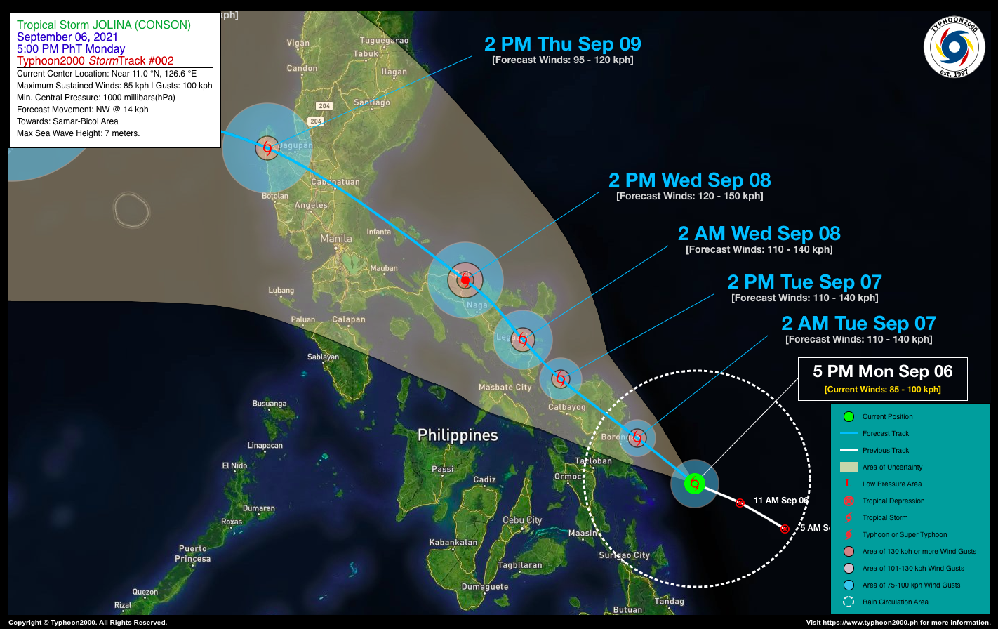
| Current Status & Outlook | JOLINA rapidly strengthened into a Tropical Storm (TS), now know internationally as “CONSON” – named after a historical place in Vietnam…expected to make landfall over Eastern Samar late tonight or early tomorrow morning. Stormy weather will be expected across Eastern Visayas beginning tonight.
24-hr Outlook: TS JOLINA (CONSON) is forecast to intensify further into a Severe Tropical Storm (STS) tomorrow and will move northwestward across Eastern & Northern Samar at a forward speed of 14 km/hr. Forecast wind speeds by tomorrow morning will be at 110 km/hr (1-min avg) or even higher if the rapid intensification phase of JOLINA continues. Meanwhile, another LPA 94W located outside of the Philippine Area of Responsibility (PAR) has intensified into Tropical Depression (TD) 19W. At 5 PM today, it was located about 1,557 km East of Southern Luzon (14.3N 138.1E), with 1-min sustained winds of 45 kph and was moving North @ 11 kph. This system is not yet a threat to any part of the country as it is forecast to move towards Taiwan within the next 5 days. |
| Where is JOLINA (CONSON)? | As of 5:00 PM PhT today, September 06…0900 GMT:
|
| How strong is it? | Maximum Sustained Winds (1-min avg): 85 kph near the center…Gustiness: 100 kph. |
| Past Movement (06 hrs) | West-Northwest @ 14 kph, towards Samar & Bicol Region |
| Potential Philippine Landfall Area(s) |
|
| What Philippine areas will be directly affected? | Heavy to Extreme Rainfall (50 mm to >100 mm expected for 24 hrs):
Damaging Winds (gusts of more than 100 km/hr expected):
|
| Potential Storm Surge/Coastal Flooding Areas+ |
+Waves of 3 meters in height is expected in storm surge-prone areas, particularly in coastal areas on where the Tropical Cyclone is headed. Kindly visit the PAGASA Storm Surge Updates for more details. |
| 3-Day Forecast Outlook Summary** |
**Important Note: Please be reminded that the Forecast Outlook changes every 6 hours, and the Day 2 and 3 Forecast Track have an average error of 100 and 250 km respectively… while the wind speed forecast error, averages 35 km/hr per day. Therefore, a turn to the left or right of its future track and changes in its wind speed must be anticipated from time to time. |
| Other Storm’s Meteorological Information |
|
| Information based on data collected by Typhoon2000 (T2k) shall not be taken as official data. Weather information broadcasted and distributed by PAGASA remains as official data. Typhoon2000 (T2k) shall not be responsible for the private use and reliance of its weather information. | |
Issued by: David Michael V. Padua for Typhoon2000 (T2K)
Typhoon2000 (T2K) Integrated Multi-Agency Tracks
PAGASA TROPICAL CYCLONE WIND SIGNAL
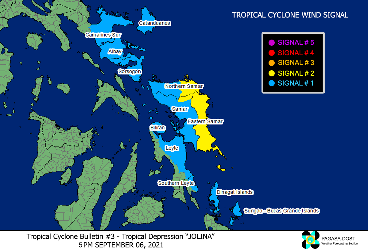
Image/Screenshot Source: DOST-PAGASA (http://bagong.pagasa.dost.gov.ph/tropical-cyclone-bulletin-iframe)


