SEVERE TROPICAL STORM FABIAN (IN-FA) STORMWATCH NO. 04

Issued at: 7:00 PM PhT (11:00 GMT) Monday, 19 July 2021
Next update: 7:00 PM PhT (11:00 GMT) Tuesday, 20 July 2021
Current Status and Outlook

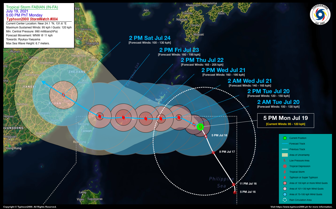
FABIAN (IN-FA) rapidly strengthened into a Severe Tropical Storm (STS) while moving very slowly, north-northwest along the northeasternmost portion of the North Philippine Sea…continues to threaten Southern Ryukyus & Yaeyama Islands.

STS FABIAN (IN-FA) is forecast to intensify further within the next 12 to 24 hours and could become a Typhoon (TY) by tomorrow afternoon. It shall then turn sharply west-northwestward slowly at 11 kph. 

Where is FABIAN (IN-FA)? As of 5:00 PM PhT today, July 19…0900 GMT:

  • Location of Center: Over the northeastern part of the North Philippine Sea (near 24.1°N 131.6°E)
  • Distance 1: 452 km east-southeast of Okinawa, Japan
  • Distance 2: 1,068 km east-northeast of Itbayat, Batanes
  • Distance 3: 1,020 km east of Taipei, Taiwan
How strong is it? Maximum Sustained Winds (1-min avg): 95 kph near the center…Gustiness: 120 kph.
Past Movement (06 hrs) Northwest @ 05 kph, towards the Southern Ryukyus-Yaeyama Islands.
Forecast Highlights
  • STS IN-FA (FABIAN) remains far away from the Philippine Landmass, with no direct effect. However, the presence of this system plus another cyclone, STS CEMPAKA, located near Hong Kong – will continue to enhance the Southwest Monsoon (#Habagat) bringing scattered to “on-&-off” rain showers and thunderstorms with 30-60 kph winds across the western sections of the country through Friday, July 23.
  • For the next three (3) days, STS FABIAN (IN-FA) is forecast to track generally westward, passing to the south of Okinawa on Wednesday morning (Jul 21), and traversing the Yaeyama-Miyako Islands on Thursday (Jul 22) as a 165 km/hr TY (Category 02). The probability of this forecast is high to medium and was based on the latest (8am) Typhoon Global Models.
  • It may exit the northwestern border of the Philippine Area of Responsibility (PAR) on Friday evening (July 23).
  • This StormWatch is valid for the next 24 hours.
Information based on data collected by Typhoon2000 (T2k) shall not be taken as official data. Weather information broadcasted and distributed by PAGASA remains as official data. Typhoon2000 (T2k) shall not be responsible for the private use and reliance of its weather information.

Issued by: David Michael V. Padua for T2K


o


CONTACT US

We're not around right now. But you can send us an email and we'll get back to you, asap.

Sending

©2024 Typhoon2000.

Log in with your credentials

Forgot your details?