


TYPHOON EGAY (DOKSURI) ADVISORY NO. 07Issued at: 8:30 AM PhT (00:30 GMT) Wednesday, 26 July 2023
Next update: 2:00 PM PhT (06:00 GMT) Wednesday, 26 July 2023 |
|
|---|---|
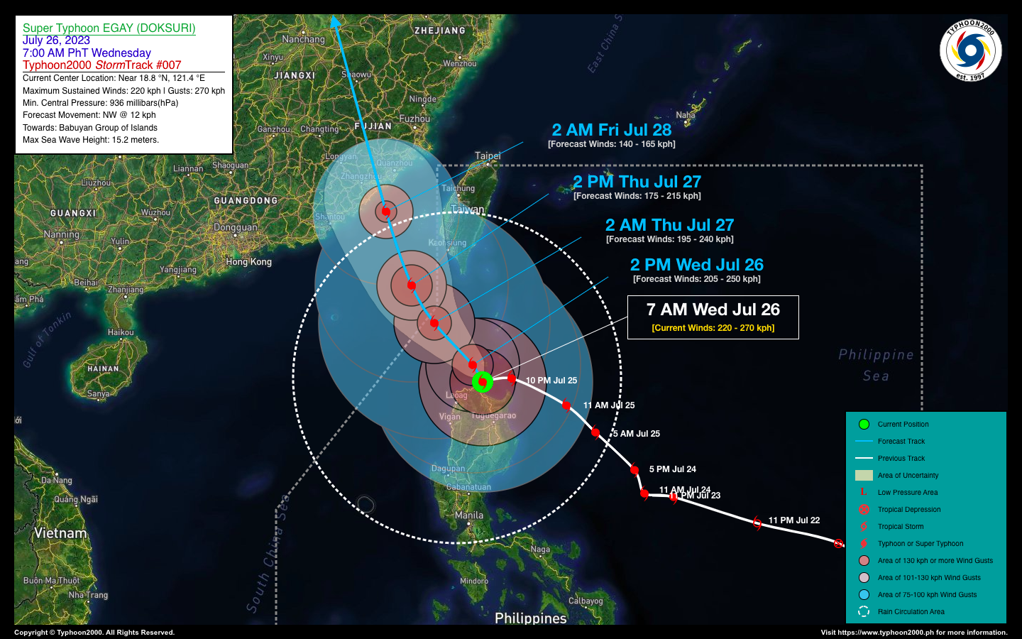
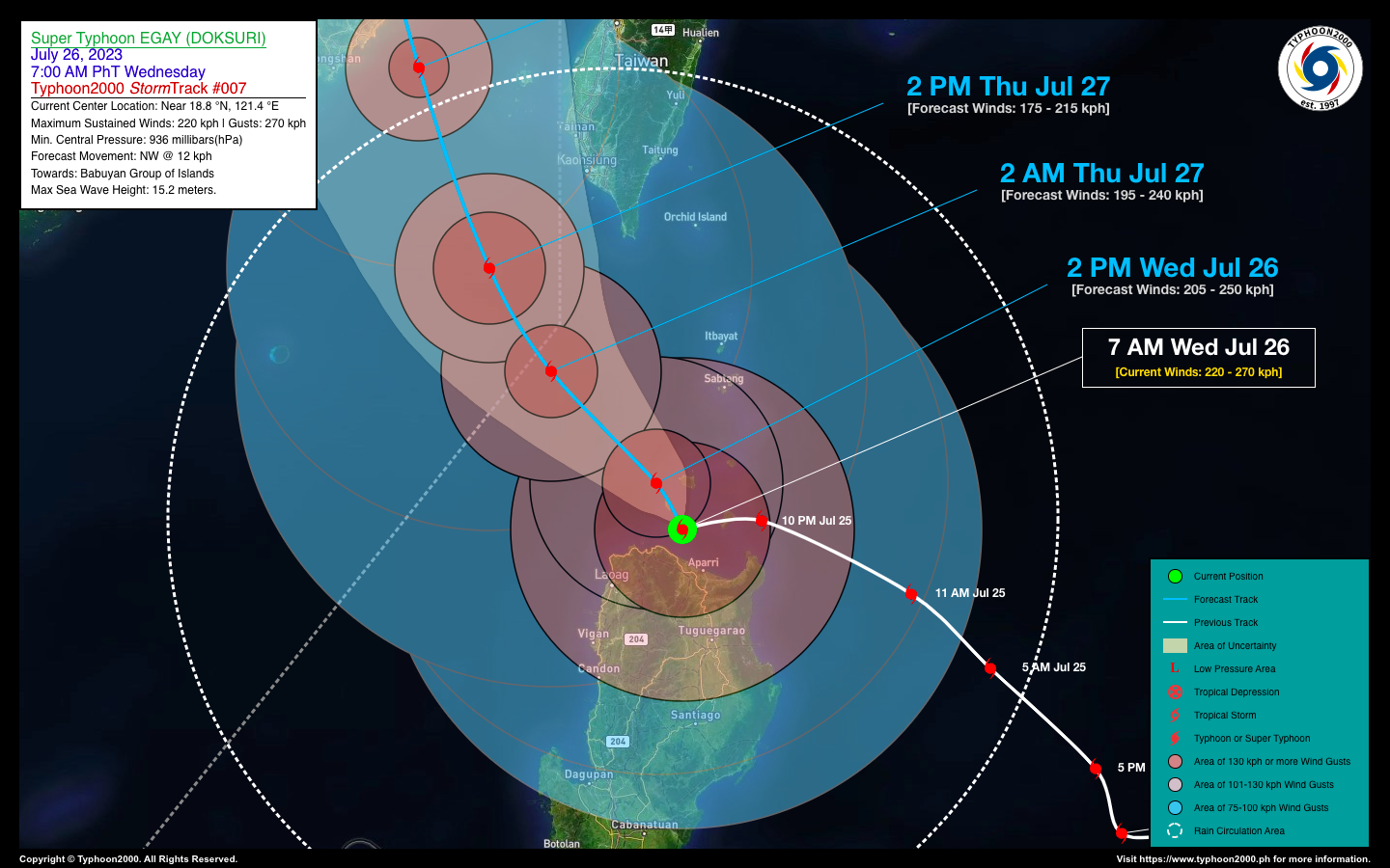
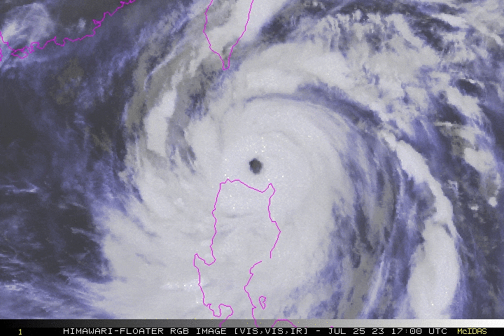
| Current Status & Outlook | Typhoon (TY) EGAY [DOKSURI] has made its second “islandfall” over Fuga Island after turning westward during the past 6 hours, then is currently wobbling over the area as the core undergoes an Eyewall Replacement Cycle (ERC). Violent wind conditions will continue to affect Western Babuyan Islands and the Northwestern Coastline of Cagayan. Meanwhile, its wide rainbands will continue to dump Northern Luzon with 24-hr. rainfall of more than 100 mm.
48-hr Outlook: TY EGAY (DOKSURI) is expected to resume its northwesterly track, and pass along Dalupiri Island in the next couple hours. Then, later this afternoon, the core will moving just along the western coastal waters of Calayan Island, before heading towards the western portion of the Bashi Channel later tonight. TY EGAY is forecast to weaken further, and will be downgraded to a Category 3 typhoon as it exits the northwestern border of the Philippine Area of Responsibility (PAR) by tomorrow morning (Jul 27). By early Friday morning (Jul 28), EGAY will be approaching the coastal areas of Fujian Province in Southern China, rapidly weakening thereafter as it makes landfall. The presence of TY EGAY (DOKSURI) will continue to enhance the Southwest Monsoon (Habagat) across Western Visayas, MiMaRoPa, and Luzon today through tomorrow (July 27). Scattered to Occasional “On-&-Off” rain showers and Severe Thunderstorms will be expected across these areas especially during the afternoon and evening. Please take all necessary precautions against floods, landslides incl. lahars, storm surges, and high winds brought about by these systems. |
| Where is EGAY (DOKSURI)? | As of 7:00 AM PhT today, July 26…2300 GMT:
|
| How strong is it? | Maximum Sustained Winds (1-min avg): 220 kph near the center…Gustiness: 270 kph. |
| Past Movement (06 hrs) | West @ 11 kph, towards Western Portions of Babuyan Islands. |
| Potential Philippine Major Landfall Area(s) |
|
| What Philippine areas will be directly affected? | Heavy to Extreme Rainfall (50 mm to >100 mm expected for 24 hrs):
Damaging Winds (gusts of more than 100 km/hr expected):
|
| Potential Storm Surge/Coastal Flooding Areas+ |
+Waves of 2 to more than 3 meters in height are expected in storm surge-prone areas, particularly in coastal areas where the Tropical Cyclone is headed. Kindly visit the PAGASA Storm Surge Updates for more details. |
| 2-Day Forecast Outlook Summary** |
**Important Note: Please be reminded that the Forecast Outlook changes every 6 hours, and the Day 2 and 3 Forecast Track have an average error of 100 and 250 km respectively… while the wind speed forecast error, averages 35 km/hr per day. Therefore, a turn to the left or right of its future track and changes in its wind speed must be anticipated from time to time. |
| Other Storm’s Meteorological Information |
|
| Disclaimer: Information based on data collected by Typhoon2000 (T2k) shall not be taken as official data. Weather information broadcasted and distributed by PAGASA remains as official data. Typhoon2000 (T2k) shall not be responsible for the private use and reliance of its weather information. | |
Issued by: David Michael V. Padua for Typhoon2000 (T2k)
Typhoon2000 (T2K) Integrated Multi-Agency Tracks
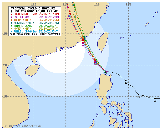
For more info visit: (http://www.typhoon2000.ph/multi/?name=DOKSURI)
PAGASA TROPICAL CYCLONE WIND SIGNAL

Image/Screenshot Source: DOST-PAGASA (https://bagong.pagasa.dost.gov.ph/tropical-cyclone/severe-weather-bulletin)


