
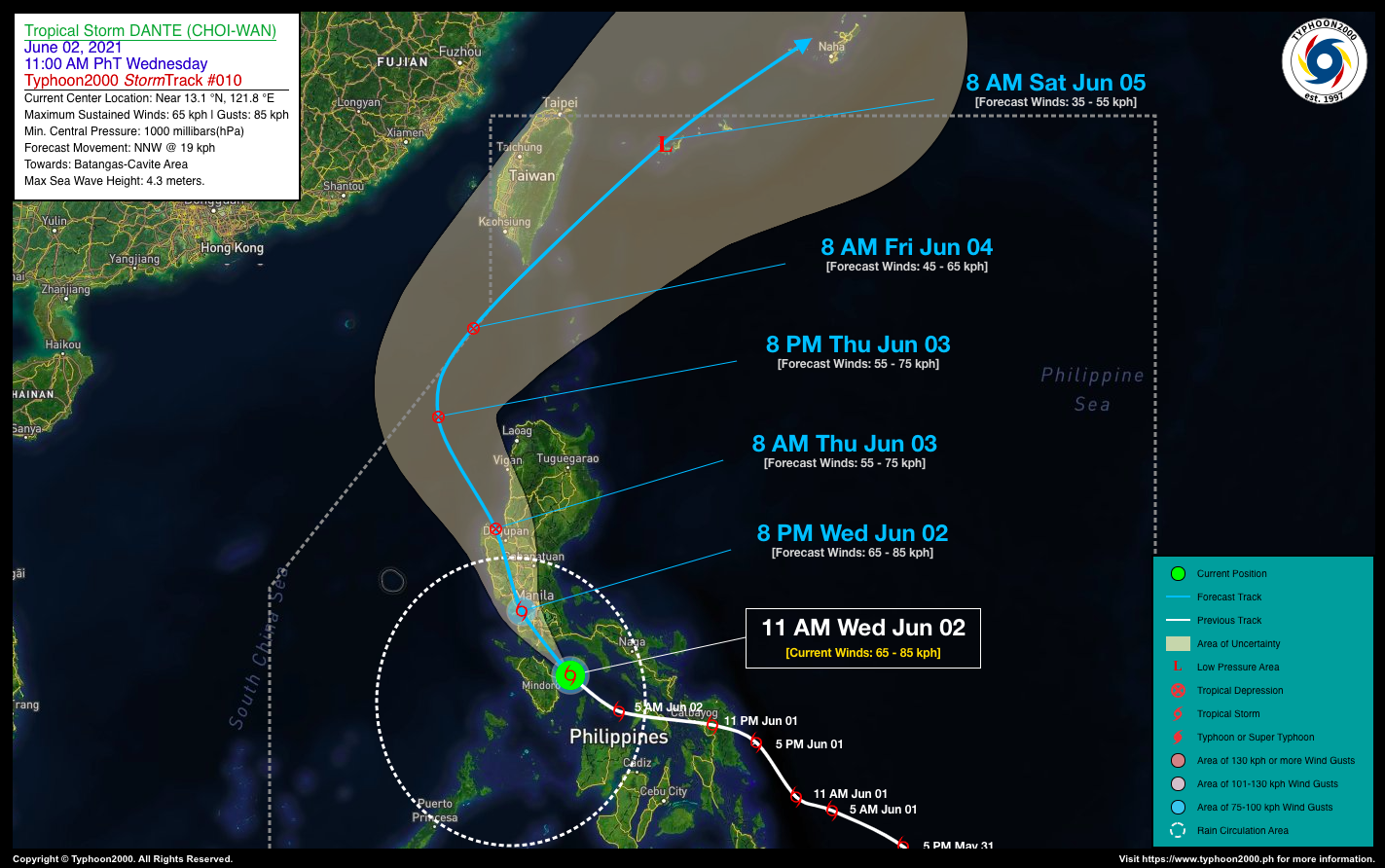

TROPICAL STORM DANTE (CHOI-WAN) ADVISORY NO. 10Issued at: 1:00 PM PhT (05:00 GMT) Wednesday, 02 June 2021
Next update: 7:00 PM PhT (11:00 GMT) Wednesday, 02 June 2021 |
|
|---|---|
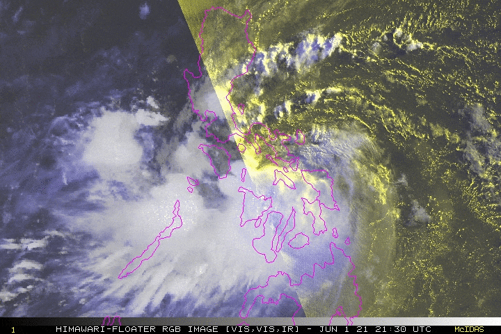
| Current Status & Outlook | Tropical Storm DANTE (CHOI-WAN) has slowed down while turning northwestward with no change in strength during the past 6 hours. The core is currently passing along Tablas Straight (in between Marinduque & Oriental Mindoro)…approaching Batangas’ Coastline.
Its rainbands together with its trough (extension) will continue to affect Western Visayas, MiMaRoPa, Western Bicol, CaLaBaRZon, Metro Manila, and portions of Central Luzon. Occasional rains with scattered Severe thunderstorms and gusty winds will be expected across these areas today. 24-hr Outlook: TS DANTE is expected to move NNW @ 19 kph and will make landfall along Batangas this afternoon between 2 to 4 PM and will traverse Cavite on or before sunset, before moving across Manila Bay early this evening. The storm will make another landfall tonight, along Western Bulacan-Eastern Bataan Area (8 to 10 PM), and will traverse Zambales-Pampanga-Tarlac-Pangasinan between 10 PM tonight to 6 AM tomorrow (Jun 03). By tomorrow morning (8 AM), DANTE will be in the vicinity of Cape Bolinao-Lingayen Gulf Area (Pangasinan), and will be just a weakened Tropical Depression (TD). |
| Where is DANTE (CHOI-WAN)? | As of 11:00 AM PhT today, June 02…0300 GMT:
|
| How strong is it? | Maximum Sustained Winds (1-min avg): 65 kph near the center…Gustiness: 85 kph. |
| Past Movement (06 hrs) | Northwest @ 25 kph, towards Batangas-Cavite-Bataan-Bulacan Area |
| Potential Philippine Landfall Area(s) |
|
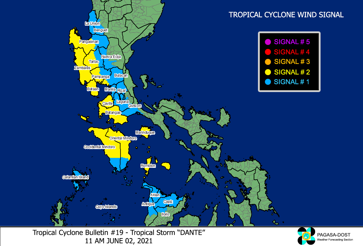
| What Philippine areas will be directly affected? | Heavy to Extreme Rainfall (50 mm to >100 mm expected for 24 hrs):
Damaging Winds (gusts of more than 100 km/hr expected):
|
| Potential Storm Surge/Coastal Flooding Areas+ |
+Waves of 3 meters in height is expected in storm surge-prone areas, particularly in coastal areas on where the Tropical Cyclone is headed. Kindly visit the PAGASA Storm Surge Updates for more details. |
| 3-Day Forecast Outlook Summary** |
**Important Note: Please be reminded that the Forecast Outlook changes every 6 hours, and the Day 2 and 3 Forecast Track have an average error of 100 and 250 km respectively… while the wind speed forecast error, averages 35 km/hr per day. Therefore, a turn to the left or right of its future track and changes in its wind speed must be anticipated from time to time. |
| Other Storm’s Meteorological Information |
|
| Information based on data collected by Typhoon2000 (T2k) shall not be taken as official data. Weather information broadcasted and distributed by PAGASA remains as official data. Typhoon2000 (T2k) shall not be responsible for the private use and reliance of its weather information. | |
Issued by: David Michael V. Padua for Typhoon2000 (T2K)
Typhoon2000 (T2K) Integrated Multi-Agency Tracks
 For more info: http://www.typhoon2000.ph/multi/?name=CHOI-WAN
PAGASA TROPICAL CYCLONE WIND SIGNAL
Image/Screenshot Source: DOST-PAGASA (http://pubfiles.pagasa.dost.


