
TROPICAL STORM DANTE (CHOI-WAN) ADVISORY NO. 05Issued at: 7:00 AM PhT (23:00 GMT) Tuesday, 01 June 2021
Next update: 1:00 PM PhT (05:00 GMT) Tuesday, 01 June 2021 |
|
|---|---|
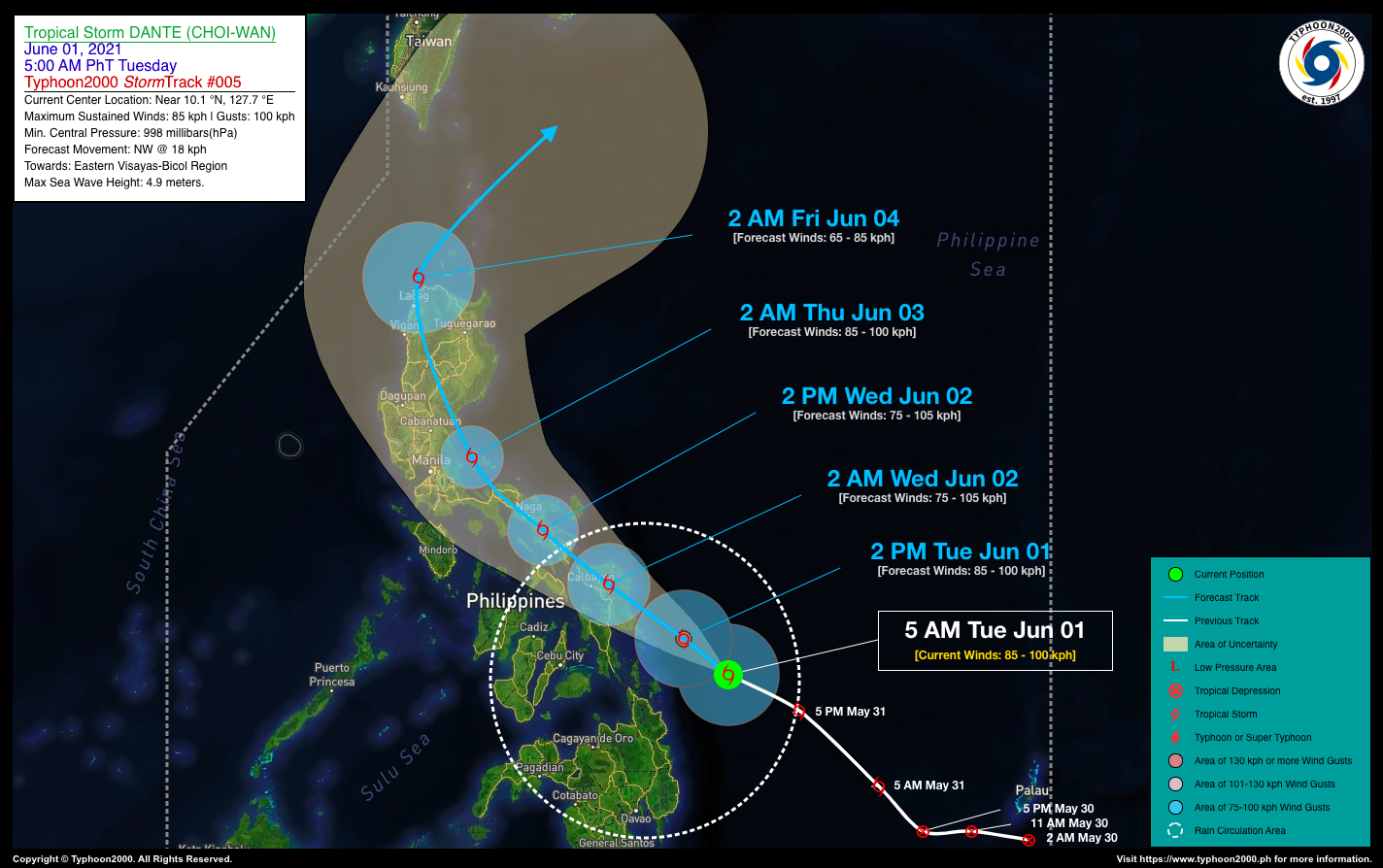
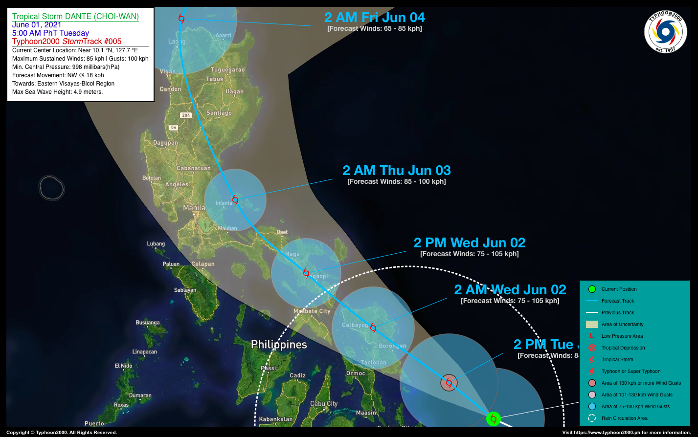
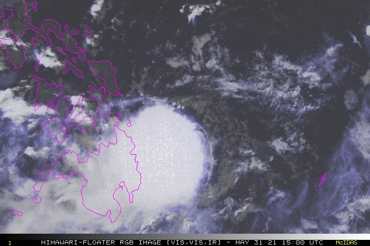
| Current Status & Outlook | Tropical Storm DANTE (CHOI-WAN) continues to struggle while over the Philippine Sea, with most of its rainbands displaced west and south of the exposed, low-level center. Its wind velocity remains at 85 km/hr and was moving west-northwest towards Eastern Visayas & Bicol Region.
Its western rainbands & trough (extension) will continue to affect Mindanao & Visayas, and is now affecting Southern Bicol. Scattered to widespread rain showers & Severe thunderstorms with gusty winds will be expected across these areas today. 24-hr Outlook: TS DANTE is forecast to move northwestward across the southwestern portion of the Central Philippine Sea at a forward speed of 18 km/hr…and is expected to make landfall over or near Borongan City, Eastern Samar between 9-11 PM tonight. The storm will slightly weaken while crossing the rugged terrain of Samar Island, and will be in the vicinity of San Jose De Buan, Samar around 2:00 AM tomorrow morning. |
| Where is DANTE (CHOI-WAN)? | As of 5:00 AM PhT today, June 01…2300 GMT:
|
| How strong is it? | Maximum Sustained Winds (1-min avg): 85 kph near the center…Gustiness: 100 kph. |
| Past Movement (06 hrs) | West-Northwest @ 20 kph, towards Eastern Visayas-Bicol Region Area |
| Potential Philippine Landfall Area(s) |
|
| What Philippine areas will be directly affected? | Heavy to Extreme Rainfall (50 mm to >100 mm expected for 24 hrs):
Damaging Winds (gusts of more than 100 km/hr expected):
|
| Potential Storm Surge/Coastal Flooding Areas+ |
+Waves of 3 meters in height is expected in storm surge-prone areas, particularly in coastal areas on where the Tropical Cyclone is headed. Kindly visit the PAGASA Storm Surge Updates for more details. |
| 3-Day Forecast Outlook Summary** |
**Important Note: Please be reminded that the Forecast Outlook changes every 6 hours, and the Day 2 and 3 Forecast Track have an average error of 100 and 250 km respectively… while the wind speed forecast error, averages 35 km/hr per day. Therefore, a turn to the left or right of its future track and changes in its wind speed must be anticipated from time to time. |
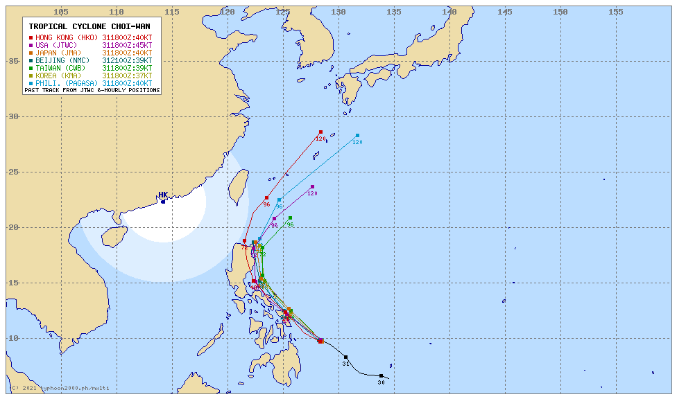
| Other Storm’s Meteorological Information |
|
| Information based on data collected by Typhoon2000 (T2k) shall not be taken as official data. Weather information broadcasted and distributed by PAGASA remains as official data. Typhoon2000 (T2k) shall not be responsible for the private use and reliance of its weather information. | |
Issued by: David Michael V. Padua for Typhoon2000 (T2K)
Typhoon2000 (T2K) Integrated Multi-Agency Tracks
 For more info: http://www.typhoon2000.ph/multi/?name=CHOI-WAN
PAGASA TROPICAL CYCLONE WIND SIGNAL

Image/Screenshot Source: DOST-PAGASA (http://pubfiles.pagasa.dost.


