
TROPICAL DEPRESSION DANTE ADVISORY NO. 01Issued at: 11:00 AM PhT (03:00 GMT) Sunday, 30 May 2021
Next update: 7:00 PM PhT (11:00 GMT) Sunday, 30 May 2021 |
|
|---|---|
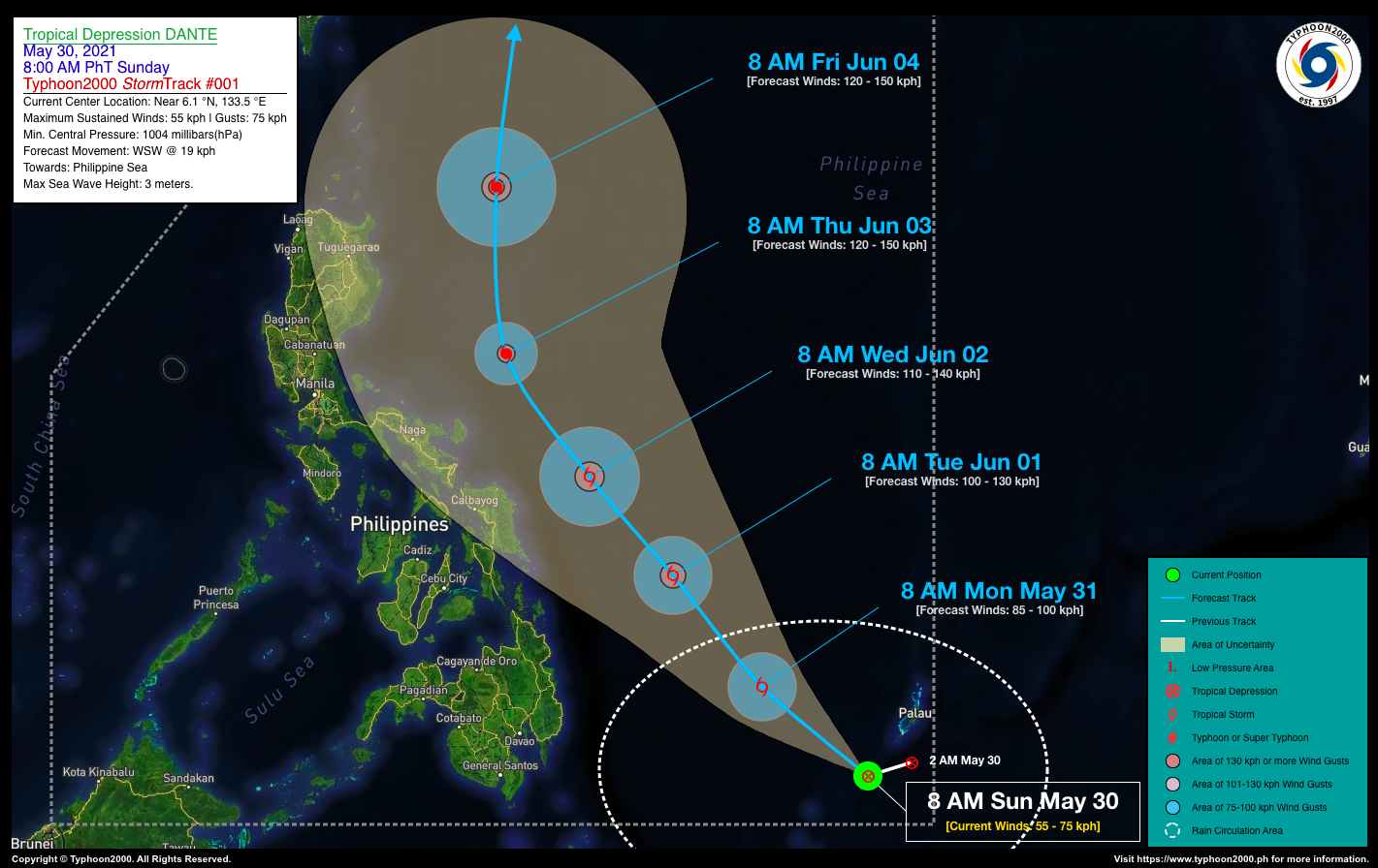
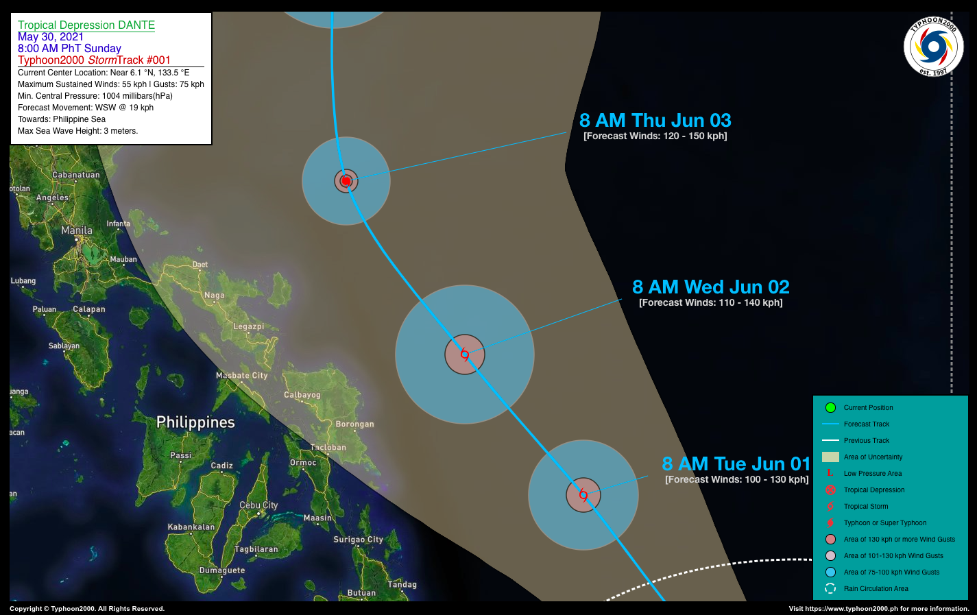
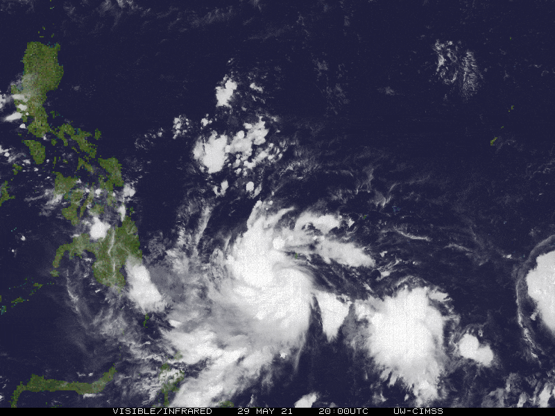
| Current Status & Outlook | The broad Tropical Disturbance (LPA 99W) over Palau has entered the southeastern border of the Philippine Area of Responsibility (PAR) and is now Tropical Depression “DANTE”…moving almost Westward across the South Philippine Sea.
The western trough (extension) will bring spread across Mindanao & Eastern Visayas – where isolated to scattered rain showers & thunderstorms will be expected today & tomorrow. 24-hr Outlook: TD DANTE is forecast to intensify quickly and move west-northwest to northwestward across the South Philippine Sea at a decreased forward speed of 16 km/hr. It will become a Tropical Storm (TS) by late today or tomorrow morning. |
| Where is DANTE? | As of 8:00 AM PhT today, May 30…0000 GMT:
|
| How strong is it? | Maximum Sustained Winds (1-min avg): 55 kph near the center…Gustiness: 75 kph. |
| Past Movement (06 hrs) | West-Southwest @ 19 kph, across the South Philippine Sea |
| Potential Philippine Landfall Area(s) |
|
| What Philippine areas will be directly affected? | Heavy to Extreme Rainfall (50 mm to >100 mm expected for 24 hrs):
Damaging Winds (gusts of more than 100 km/hr expected):
|
| Potential Storm Surge/Coastal Flooding Areas+ |
+Waves of 3 meters in height is expected in storm surge-prone areas, particularly in coastal areas on where the Tropical Cyclone is headed. Kindly visit the PAGASA Storm Surge Updates for more details. |
| 3-Day Forecast Outlook Summary** |
**Important Note: Please be reminded that the Forecast Outlook changes every 6 hours, and the Day 2 and 3 Forecast Track have an average error of 100 and 250 km respectively… while the wind speed forecast error, averages 35 km/hr per day. Therefore, a turn to the left or right of its future track and changes in its wind speed must be anticipated from time to time. |
| Other Storm’s Meteorological Information |
|
| Information based on data collected by Typhoon2000 (T2k) shall not be taken as official data. Weather information broadcasted and distributed by PAGASA remains as official data. Typhoon2000 (T2k) shall not be responsible for the private use and reliance of its weather information. | |
Issued by: David Michael V. Padua for Typhoon2000 (T2K)
Typhoon2000 (T2K) Integrated Multi-Agency Tracks
:: None yet. Will be available once RSMC’s Tokyo Typhoon Center (JMA) upgrades it into a Tropical Storm ::
PAGASA TROPICAL CYCLONE WIND SIGNAL
:: None
Image/Screenshot Source: DOST-PAGASA (http://pubfiles.pagasa.dost.


