


SUPER TYPHOON BETTY (MAWAR) ADVISORY NO. 01Issued at: 2:00 PM PhT (06:00 GMT) Saturday, 27 May 2023
Next update: 8:00 PM PhT (12:00 GMT) Saturday, 27 May 2023 |
|
|---|---|
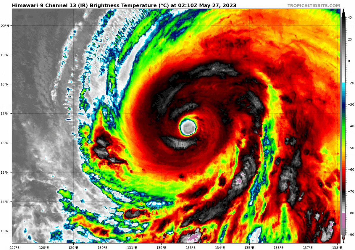
| Current Status & Outlook | Super Typhoon (STY) MAWAR has weakened further after entering the Philippine Area of Responsibility (PAR) early this morning…maintains its west-northwest track at a slightly faster pace. This powerful system is now named domestically as “BETTY.” Latest forecast continues to show a decrease in forward speed and a recurvature scenario on Tuesday & Wednesday (May 30-31).
48-hr Outlook: STY BETTY (MAWAR) is forecast to slightly weaken for the next 2 days as it encounters dry-air entrainment, increasing upper-level winds (wind shear) and cooler sea-surface temperatures along the way. The system will be downgraded from STY classification with decrease winds of about 215 kph (Cat 4) or lower. |
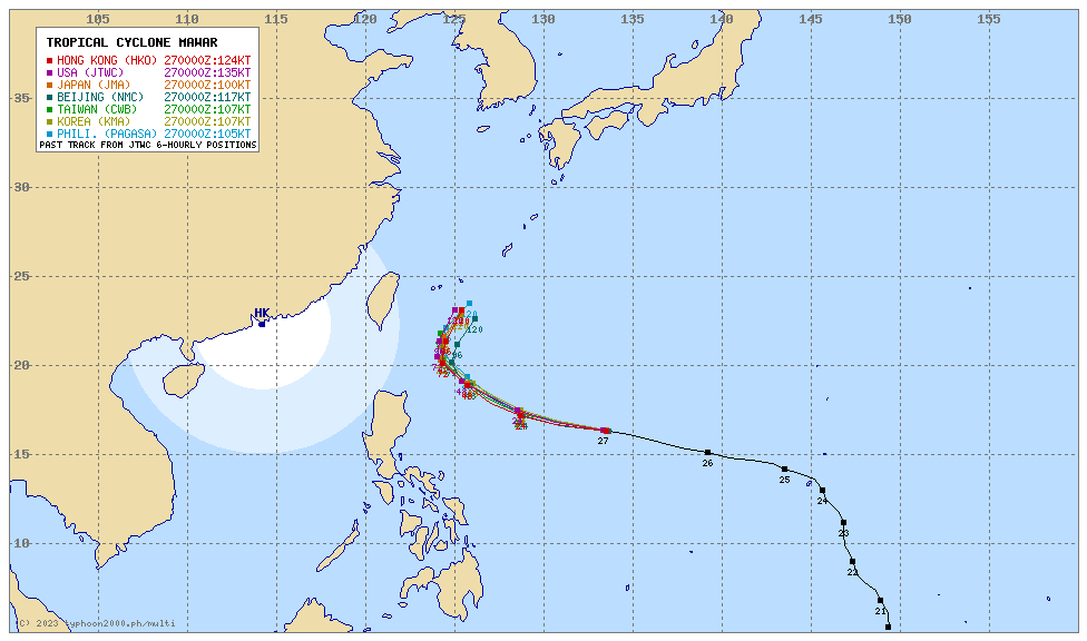
| Where is BETTY (MAWAR)? | As of 8:00 AM PhT today, May 27…0000 GMT:
|
| How strong is it? | Maximum Sustained Winds (1-min avg): 250 kph near the center…Gustiness: 310 kph. |
| Past Movement (06 hrs) | West-Northwest @ 24 kph, towards the North Philippine Sea. |
| Potential Philippine Major Landfall Area(s) |
|
| What Philippine areas will be directly affected? | Heavy to Extreme Rainfall (50 mm to >100 mm expected for 24 hrs):
Damaging Winds (gusts of more than 100 km/hr expected):
|
| Potential Storm Surge/Coastal Flooding Areas+ |
+Waves of 3 meters in height are expected in storm surge-prone areas, particularly in coastal areas where the Tropical Cyclone is headed. Kindly visit the PAGASA Storm Surge Updates for more details. |
| 3-Day Forecast Outlook Summary** |
**Important Note: Please be reminded that the Forecast Outlook changes every 6 hours, and the Day 2 and 3 Forecast Track have an average error of 100 and 250 km respectively… while the wind speed forecast error, averages 35 km/hr per day. Therefore, a turn to the left or right of its future track and changes in its wind speed must be anticipated from time to time. |
| Other Storm’s Meteorological Information |
|
| Disclaimer: Information based on data collected by Typhoon2000 (T2k) shall not be taken as official data. Weather information broadcasted and distributed by PAGASA remains as official data. Typhoon2000 (T2k) shall not be responsible for the private use and reliance of its weather information. | |
Issued by: David Michael V. Padua for Typhoon2000 (T2k)
Typhoon2000 (T2K) Integrated Multi-Agency Tracks
PAGASA TROPICAL CYCLONE WIND SIGNAL
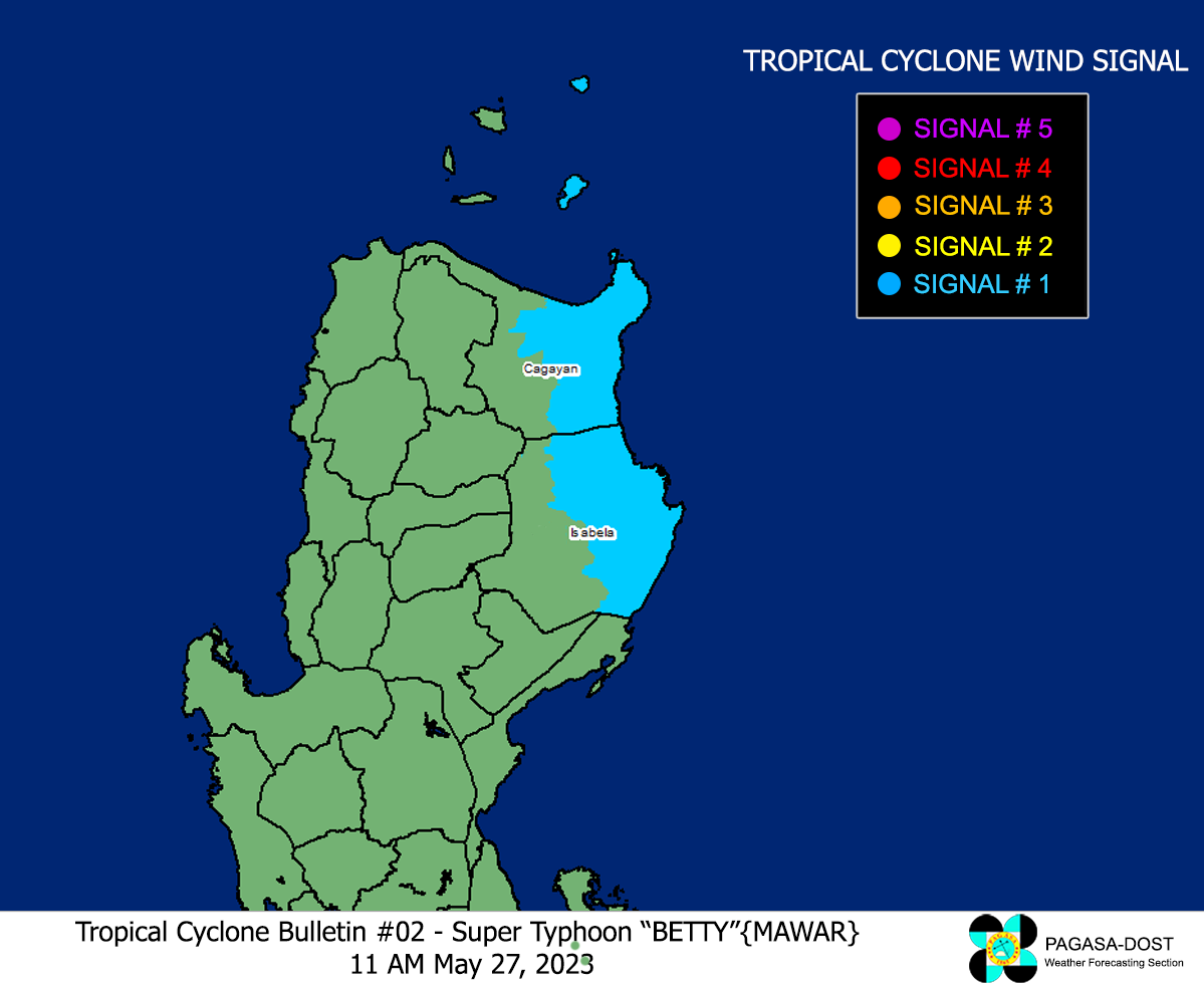
Image/Screenshot Source: DOST-PAGASA (https://bagong.pagasa.dost.gov.ph/tropical-cyclone/severe-weather-bulletin)


