


TROPICAL DEPRESSION AGATON (MEGI) ADVISORY NO. 04Issued at: 7:00 AM PhT (23:00 GMT) Monday, 11 April 2022
Next update: 7:00 PM PhT (11:00 GMT) Monday, 11 April 2022 |
|
|---|---|
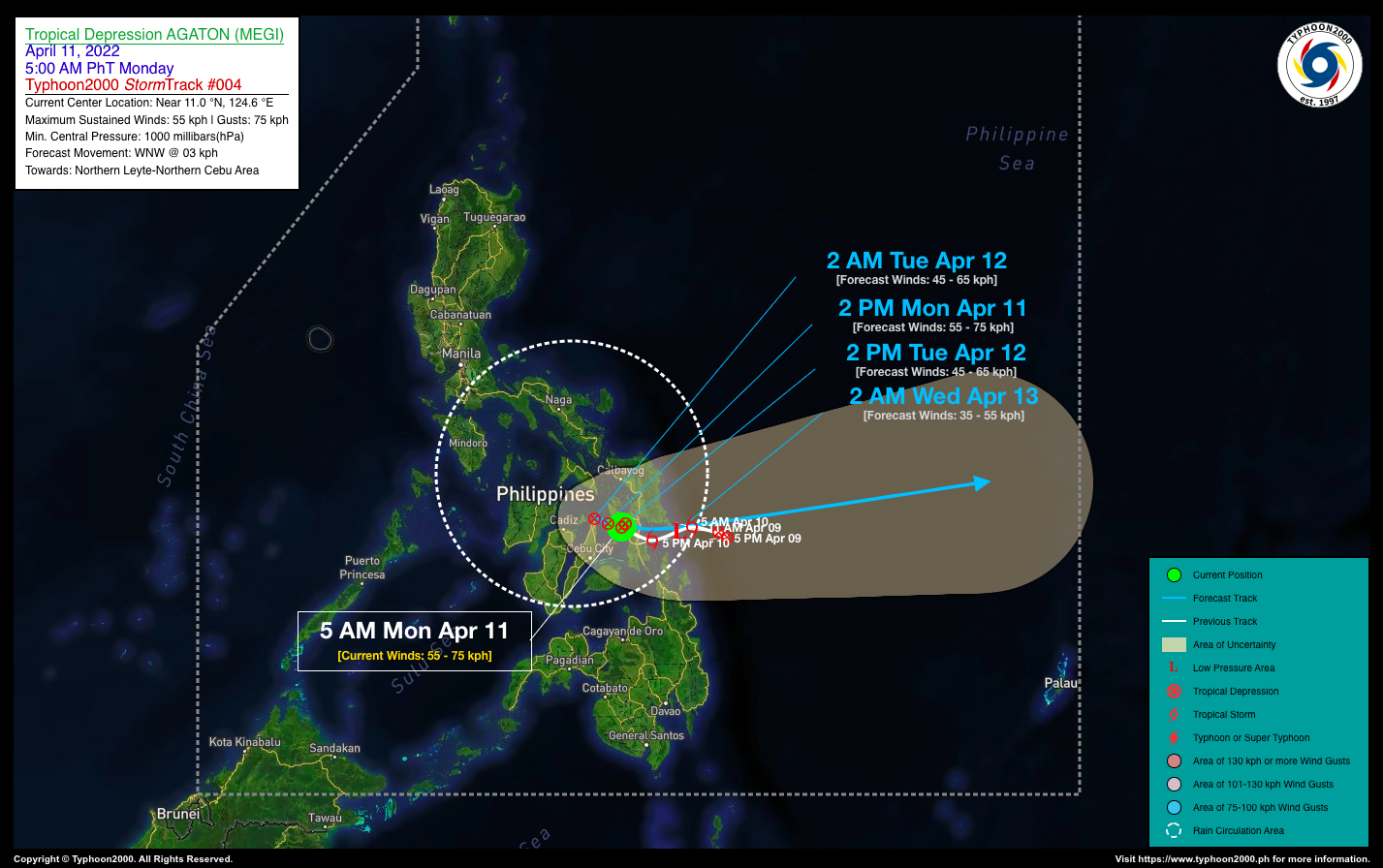
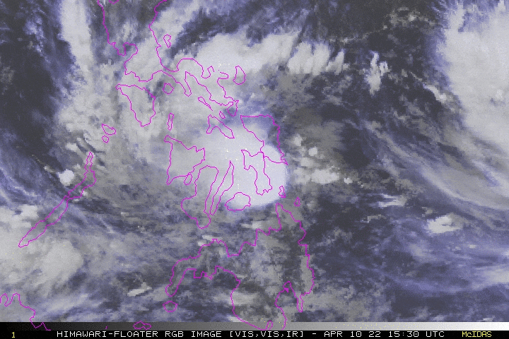
| Current Status & Outlook | AGATON (MEGI) has weakened into a Tropical Depression (TD) after it made landfall along MacArthur-Mayorga Area in Eastern Leyte late last night, and is now in the vicinity of Ormoc City. Its core of strong rainbands will continue to dump heavy to torrential rains across Leyte and Northern Cebu today.
24-hr Outlook: TD AGATON is forecast to drift very slowly, WNW @ 3 kph and will be in the vicinity of Daanbantayan, Cebu early tomorrow morning. The depression is expected to weaken further later today. Meanwhile, Severe Tropical Storm (STS) MALAKAS has maintained its strength while moving closer to the Philippine Sea, expected to brieflyenter the Philippine Area of Responsibility (PAR) early tomorrow morning (Apr 12). However, upon its entrance, STS MALAKAS is forecast to recurve northward and exit PAR on Wednesday (Apr 13) as it pulls behind the soon-to-be remants of TD Agaton (Megi). |
| Where is AGATON (MEGI)? | As of 5:00 AM PhT today, April 11…2100 GMT:
|
| How strong is it? | Maximum Sustained Winds (1-min avg): 55 kph near the center…Gustiness: 65 kph. |
| Past Movement (06 hrs) | West-Northwest @ 04 kph, across Northern Leyte. |
| Potential Philippine Major Landfall Area(s) |
|
| What Philippine areas will be directly affected? | Heavy to Extreme Rainfall (50 mm to >100 mm expected for 24 hrs):
Damaging Winds (gusts of more than 100 km/hr expected):
|
| Potential Storm Surge/Coastal Flooding Areas+ |
+Waves of 3 meters in height are expected in storm surge-prone areas, particularly in coastal areas where the Tropical Cyclone is headed. Kindly visit the PAGASA Storm Surge Updates for more details. |
| 2-Day Forecast Outlook Summary** |
**Important Note: Please be reminded that the Forecast Outlook changes every 6 hours, and the Day 2 and 3 Forecast Track have an average error of 100 and 250 km respectively… while the wind speed forecast error, averages 35 km/hr per day. Therefore, a turn to the left or right of its future track and changes in its wind speed must be anticipated from time to time. |
| Other Storm’s Meteorological Information |
|
| Information based on data collected by Typhoon2000 (T2k) shall not be taken as official data. Weather information broadcasted and distributed by PAGASA remains as official data. Typhoon2000 (T2k) shall not be responsible for the private use and reliance of its weather information. | |
Issued by: David Michael V. Padua for Typhoon2000 (T2k)
Typhoon2000 (T2K) Integrated Multi-Agency Tracks

PAGASA TROPICAL CYCLONE WIND SIGNAL

Image/Screenshot Source: DOST-PAGASA (http://bagong.pagasa.dost.gov.ph/tropical-cyclone-bulletin-iframe)


