
TROPICAL DEPRESSION CARINA ADVISORY NO. 01Issued at: 7:00 PM PhT (11:00 GMT) Monday, 13 July 2020
Next update: 7:00 AM PhT (23:00 GMT) Tuesday, 14 July 2020 |
|
|---|---|
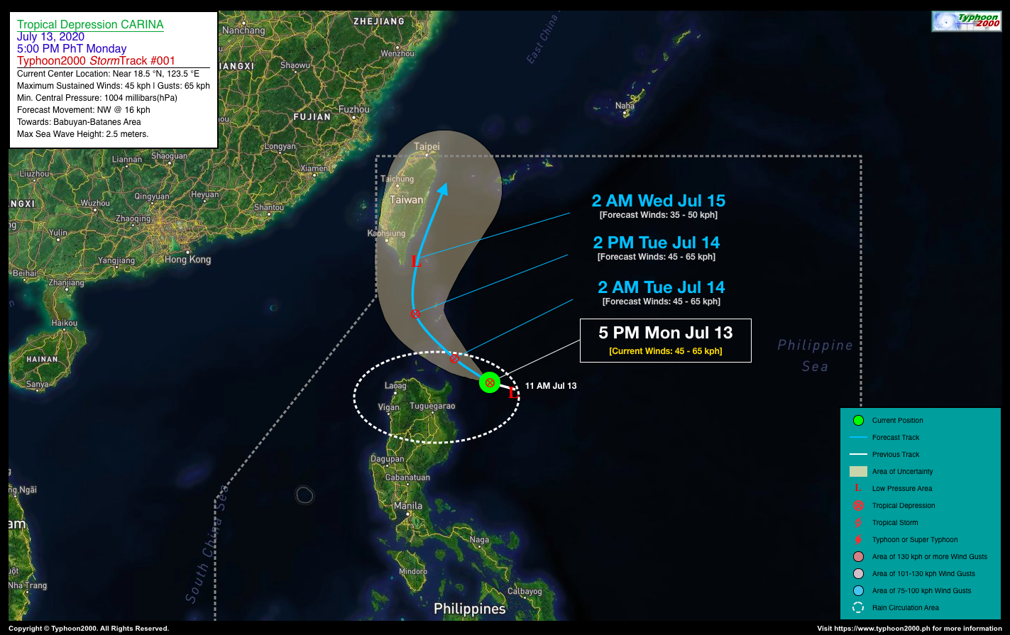
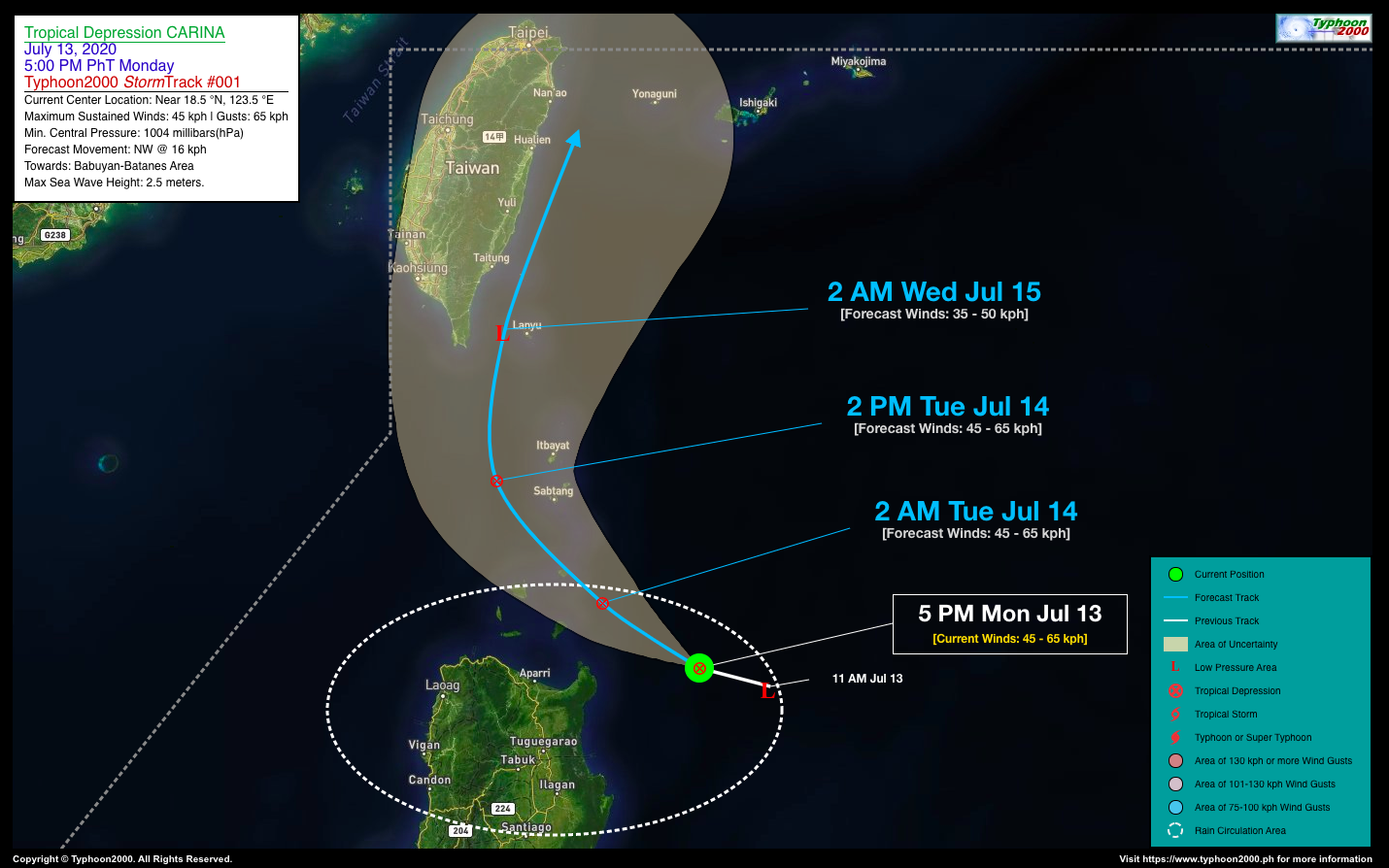
| Current Status and Outlook | Tropical Depression CARINA newly-formed near the coast of Northeastern Cagayan…approaching the Babuyan and Batanes Island Group. Widespread rain showers and thunderstorms with gusty winds expected along these areas.
24-hr Outlook: TD CARINA is forecast to maintain its strength and will move west to west-northwest at a forward speed of 16 km/hr, passing across the Balintang Channel or over the eastern portion of the Babuyan Islands by early tomorrow morning (Tuesday). It will then be over the southern part of Bashi Channel, or just west of the Batanes Islands by tomorrow afternoon. TD CARINA’s Trough will continue to bring overcast skies with isolated to scattered rain showers and thunderstorms across most parts of Luzon including Mindoro, Marinduque, and Romblon. |
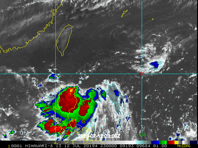
| Where is CARINA? | As of 5:00 PM PhT today, July 13…1100 GMT. The weak center was located along the southeastern portion of the Balintang Channel (near 18.5°N 123.5°E), about 148 km east of Santa Ana, Cagayan or 272 km southeast of Basco, Batanes. |
| How strong is it? | Maximum Sustained Winds (1-min avg): 45 kph near the center…Gustiness: 65 kph. |
| Past Movement (06 hrs) | West-Northwest @ 15 kph, towards Babuyan-Batanes Area. |
| Potential Philippine Landfall Area(s) | :: None. |
| What Philippine areas will be directly affected? | Heavy to Extreme Rains (50 mm to >100 mm expected in 24 hrs): >> Extreme Northern Luzon – Today. Damaging Winds (gusts of more than 100 km/hr expected): |
| Potential Storm Surge/Coastal Flooding Areas+ | :: None.
+Waves of 3 meters in height is expected in storm surge-prone areas, particularly in coastal areas on where the Tropical Cyclone is headed. Kindly visit the PAGASA Storm Surge Updates for more details. |
| 2-Day Forecast Outlook Summary** | TUESDAY AFTERNOON: Remains a weak depression as it moves across the Bashi Channel on a NW track…about 83 km W of Basco, Batanes [2PM Jul 14: 20.5°N 121.2°E @ 45kph]. Confidence Level: MEDIUM.
WEDNESDAY AFTERNOON: Weakens into a Tropical Disturbance (LPA) as it recurves towards the North/NNE parallel to the eastern coastline of Taiwan…about 399 km N of Basco, Batanes [2PM Jul 15: 24.1°N 122.1°E @ 35kph]. Confidence Level: LOW. **Important Note: Please be reminded that the Forecast Outlook changes every 6 hours, and the Day 2 and 3 Forecast Track have an average error of 100 and 250 km respectively… while the wind speed forecast error, averages 35 km/hr per day. Therefore, a turn to the left or right of its future track and changes in its wind speed must be anticipated from time to time. |
| Other Storm’s Meteorological Info | > 24 hr. Rain Accumulation (across its circulation): 25 to 200 mm [Light to Extreme]
> Minimum Central Pressure: 1004 millibars (hPa) > Size of Circulation [Convective Cloud-Based, in diameter]: 575 km (Medium) > Area of Damaging Winds (100 kph or more wind gusts): None. |
| Current Summary/Additional Reference Points | Time/Date: 5:00 PM PhT Mon July 13, 2020 Location of Center/Eye: Near 18.5°N Lat 123.5°E Lon Distance 1: 201 km E of Aparri, Cagayan Distance 2: 215 km ENE of Tuguegarao, Cagayan Distance 3: 311 km SE of Itbayat, Batanes Distance 4: 229 km ESE of Calayan Island, Cagayan Distance 5: 517 km NNE of Metro Manila 24 hr. Forecast Coordinates (Class): 20.5°N 121.2°E (TD) 48 hr. Forecast Coordinates (Class): 24.1°N 122.1°E (LPA) |
| Information based on data collected by Typhoon2000 (T2K) shall not be taken as official data. Weather information broadcasted and distributed by PAGASA remains as official data. Typhoon2000 (T2K) shall not be responsible for the private use and reliance of its weather information. | |
Issued by: David Michael V. Padua for Typhoon2000 (T2K)
PAGASA TROPICAL CYCLONE WIND SIGNAL

Image Source: DOST-PAGASA (http://pubfiles.pagasa.dost.


