
SUPER TYPHOON ROLLY (GONI) ADVISORY NO. 09Issued at: 1:00 AM PhT (17:00 GMT) Sunday, 01 November 2020
Next update: 7:00 AM PhT (23:00 GMT) Sunday, 01 November 2020 |
|
|---|---|
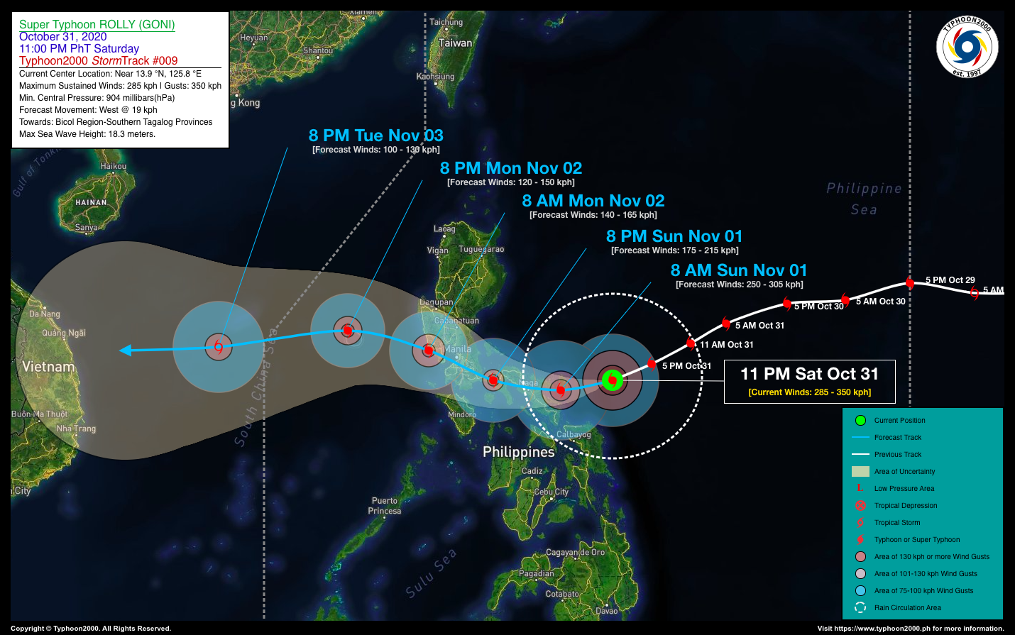
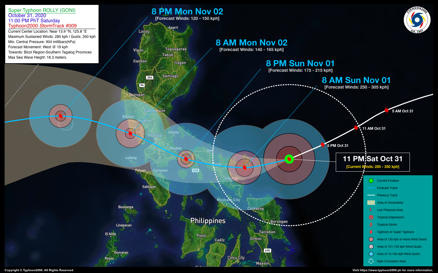
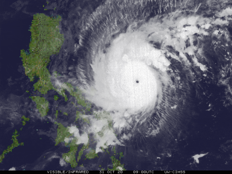
| Current Status & Outlook | Extremely Catastrophic Super Typhoon ROLLY (GONI)* has maintained its strength as it moves closer to Catanduanes, endangering the Bicol Region with violent winds and extreme rainfall. Landfall is now imminent over Catanduanes and Eastern Camarines Sur or Eastern Albay within the next 6 hours, with a high strike probability of 95-100%.
*This tropical cyclone is similar in strength and track of Super Typhoon ROSING (ANGELA) which devastated the Bicol Region, Central & Southern Luzon in November 02-03, 1995. Please take full preparations & precautions. 24-hr Outlook: STY ROLLY (GONI) is forecast to weaken further and is expected to move westward with a decreased forward speed of 19 km/hr. The core (eye+eyewall) is expected to make landfall over Catanduanes on or after sunrise this morning, and shall do another landfall over Partido District in Camarines Sur on or before noontime today. It will then cross North-Central Camarines Sur between 12 to 4 PM, and across Southern Quezon tonight. By early Monday morning, ROLLY will traverse Laguna-Metro Manila Area, before moving out into the West Philippine Sea. |
| Where is ROLLY (GONI)? | As of 11:00 PM PhT last night, October 31…1500 GMT:
|
| How strong is it? | Maximum Sustained Winds (1-min avg): 285 kph near the center…Gustiness: 350 kph. |
| Past Movement (06 hrs) | West-Southwest @ 23 kph, towards Bicol Region-Southern Quezon-NCR Area |
| Potential Philippine Landfall Area(s) |
|
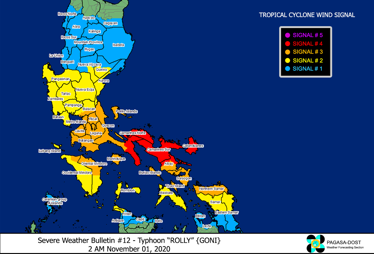
| What Philippine areas will be directly affected? | Heavy to Extreme Rainfall (50 mm to >100 mm expected for 24 hrs):
Damaging Winds (gusts of more than 100 km/hr expected):
|
| Potential Storm Surge/Coastal Flooding Areas+ |
+Waves of 3 meters in height is expected in storm surge-prone areas, particularly in coastal areas on where the Tropical Cyclone is headed. Kindly visit the PAGASA Storm Surge Updates for more details. |
| 2-Day Forecast Outlook Summary** |
**Important Note: Please be reminded that the Forecast Outlook changes every 6 hours, and the Day 2 and 3 Forecast Track have an average error of 100 and 250 km respectively… while the wind speed forecast error, averages 35 km/hr per day. Therefore, a turn to the left or right of its future track and changes in its wind speed must be anticipated from time to time. |
| Other Storm’s Meteorological Information |
|
| Information based on data collected by Typhoon2000 (T2k) shall not be taken as official data. Weather information broadcasted and distributed by PAGASA remains as official data. Typhoon2000 (T2k) shall not be responsible for the private use and reliance of its weather information. | |
Issued by: David Michael V. Padua for Typhoon2000 (T2K)
PAGASA TROPICAL CYCLONE WIND SIGNAL
Image/Screenshot Source: DOST-PAGASA (http://pubfiles.pagasa.dost.


