

SUPER TYPHOON ROLLY (GONI) ADVISORY NO. 07Issued at: 1:00 PM PhT (05:00 GMT) Saturday, 31 October 2020
Next update: 7:00 PM PhT (11:00 GMT) Saturday, 31 October 2020 |
|
|---|---|
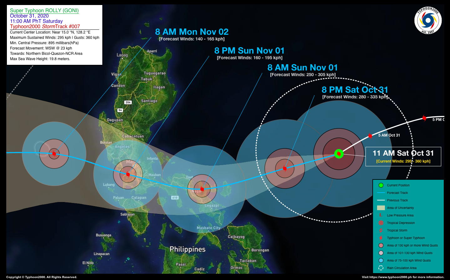
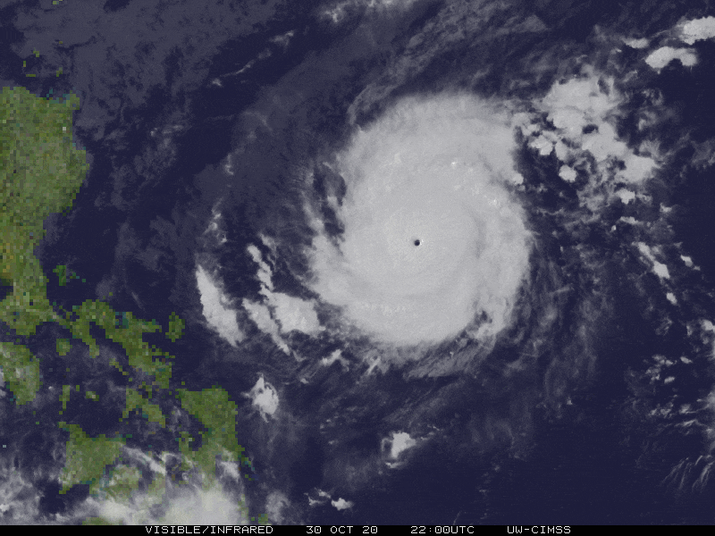
| Current Status & Outlook | Super Typhoon ROLLY (GONI)* might have reached its peak strength as it continues to intensify during the past six (6) hours…remains an Extremely Catastrophic (Category 5) Tropical Cyclone. It remains a serious threat to Bicol Region, Southern & Central Luzon including the National Capital Region (NCR).
*Similar in strength and track of Super Typhoon ROSING (ANGELA) which devastated the Bicol Region, Central & Southern Luzon in November 02-03, 1995. Please take full preparations & precautions. The potential landfall area will be tomorrow morning, November 01, along Northern Catanduanes and the Northern Portions of Camarines Provinces with a high strike probability of 90%. 24-hr Outlook: STY ROLLY (GONI) is forecast to weaken slightly (at Category 4 status) as it maintains its west-southwestward movement with an increased forward speed of 25 km/hr. The core (eye+eyewall) is expected to make landfall over Northern Catanduanes before sunrise tomorrow morning, and shall do another landfall over Partido District in Camarines Sur, passing over Caramoan-Lagonoy Area between 6-7 AM, and could be in the vicinity of Tinambac-San Miguel Bay Area between 7-8 AM tomorrow morning. |
| Where is ROLLY (GONI)? | As of 11:00 AM PhT today, October 31…0300 GMT:
|
| How strong is it? | Maximum Sustained Winds (1-min avg): 295 kph near the center…Gustiness: 360 kph. |
| Past Movement (06 hrs) | West-Southwest @ 23 kph, towards Northern Bicol-Quezon-NCR Area |
| Potential Philippine Landfall Area(s) |
|
| What Philippine areas will be directly affected? | Heavy to Extreme Rainfall (50 mm to >100 mm expected for 24 hrs):
Damaging Winds (gusts of more than 100 km/hr expected):
|
| Potential Storm Surge/Coastal Flooding Areas+ |
+Waves of 3 meters in height is expected in storm surge-prone areas, particularly in coastal areas on where the Tropical Cyclone is headed. Kindly visit the PAGASA Storm Surge Updates for more details. |
| 3-Day Forecast Outlook Summary** |
**Important Note: Please be reminded that the Forecast Outlook changes every 6 hours, and the Day 2 and 3 Forecast Track have an average error of 100 and 250 km respectively… while the wind speed forecast error, averages 35 km/hr per day. Therefore, a turn to the left or right of its future track and changes in its wind speed must be anticipated from time to time. |
| Other Storm’s Meteorological Information |
|
| Information based on data collected by Typhoon2000 (T2k) shall not be taken as official data. Weather information broadcasted and distributed by PAGASA remains as official data. Typhoon2000 (T2k) shall not be responsible for the private use and reliance of its weather information. | |
Issued by: David Michael V. Padua for Typhoon2000 (T2K)
PAGASA TROPICAL CYCLONE WIND SIGNAL

Image/Screenshot Source: DOST-PAGASA (http://pubfiles.pagasa.dost.


