
SUPER TYPHOON ROLLY (GONI) ADVISORY NO. 05Issued at: 7:00 PM PhT (11:00 GMT) Friday, 30 October 2020
Next update: 7:00 AM PhT (23:00 GMT) Saturday, 31 October 2020 |
|
|---|---|
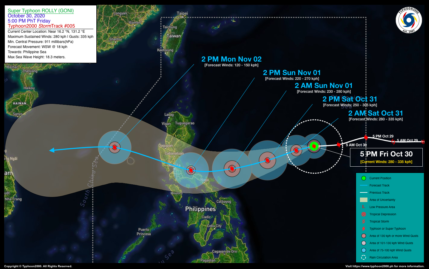
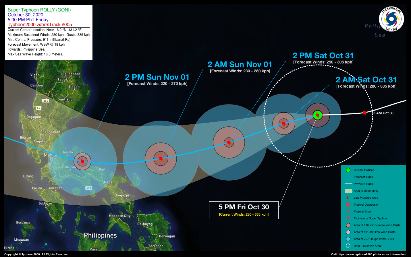
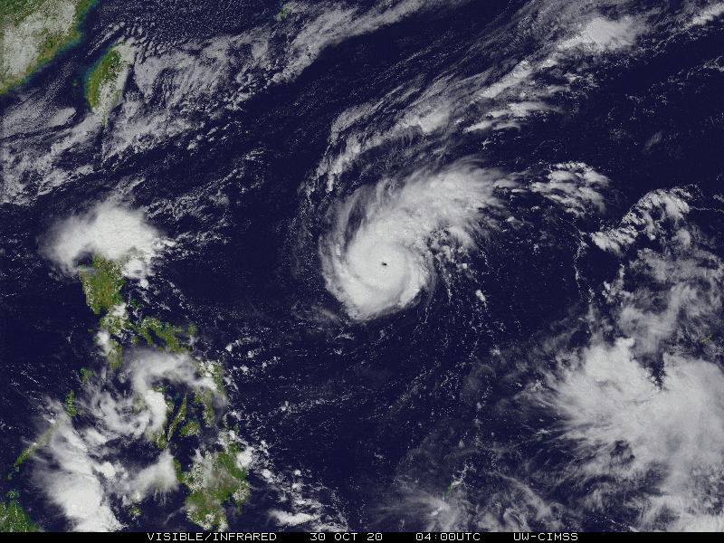
| Current Status & Outlook | ROLLY (GONI) is now an Extremely Catastrophic (Category 5) Super Typhoon after undergoing Rapid Intensification (RI) process during the past 12 hours. This howler continues to threaten the northern coastal areas of the Bicol Region, and the areas of Central & Southern Luzon including the National Capital Region (NCR).
The potential landfall area will be on the evening of November 01, along Northern Quezon with a high strike probability of 90%. 24-hr Outlook: STY ROLLY (GONI) is forecast to maintain its strength for the next 12 hours, before weakening into a Category 4 Super Typhoon on Saturday afternoon (Oct 31). It is then expected to begin sliding west-southwestward with a forward speed of 18 km/hr across the middle portion of the Central Philippine Sea. |
| Where is ROLLY (GONI)? | As of 5:00 PM PhT today, October 30…0900 GMT:
|
| How strong is it? | Maximum Sustained Winds (1-min avg): 280 kph near the center…Gustiness: 335 kph. |
| Past Movement (06 hrs) | West-Southwest @ 16 kph, towards Central Philippine Sea |
| Potential Philippine Landfall Area(s) |
|
| What Philippine areas will be directly affected? | Heavy to Extreme Rainfall (50 mm to >100 mm expected for 24 hrs):
Damaging Winds (gusts of more than 100 km/hr expected):
|
| Potential Storm Surge/Coastal Flooding Areas+ |
+Waves of 3 meters in height is expected in storm surge-prone areas, particularly in coastal areas on where the Tropical Cyclone is headed. Kindly visit the PAGASA Storm Surge Updates for more details. |
| 3-Day Forecast Outlook Summary** |
**Important Note: Please be reminded that the Forecast Outlook changes every 6 hours, and the Day 2 and 3 Forecast Track have an average error of 100 and 250 km respectively… while the wind speed forecast error, averages 35 km/hr per day. Therefore, a turn to the left or right of its future track and changes in its wind speed must be anticipated from time to time. |
| Other Storm’s Meteorological Information |
|
| Information based on data collected by Typhoon2000 (T2k) shall not be taken as official data. Weather information broadcasted and distributed by PAGASA remains as official data. Typhoon2000 (T2k) shall not be responsible for the private use and reliance of its weather information. | |
Issued by: David Michael V. Padua for Typhoon2000 (T2K)
PAGASA TROPICAL CYCLONE WIND SIGNAL

Image/Screenshot Source: DOST-PAGASA (http://pubfiles.pagasa.dost.


