
SEVERE TROPICAL STORM PEPITO (SAUDEL) ADVISORY NO. 11 [FINAL]Issued at: 7:00 AM PhT (23:00 GMT) Thursday, 22 October 2020
|
|
|---|---|
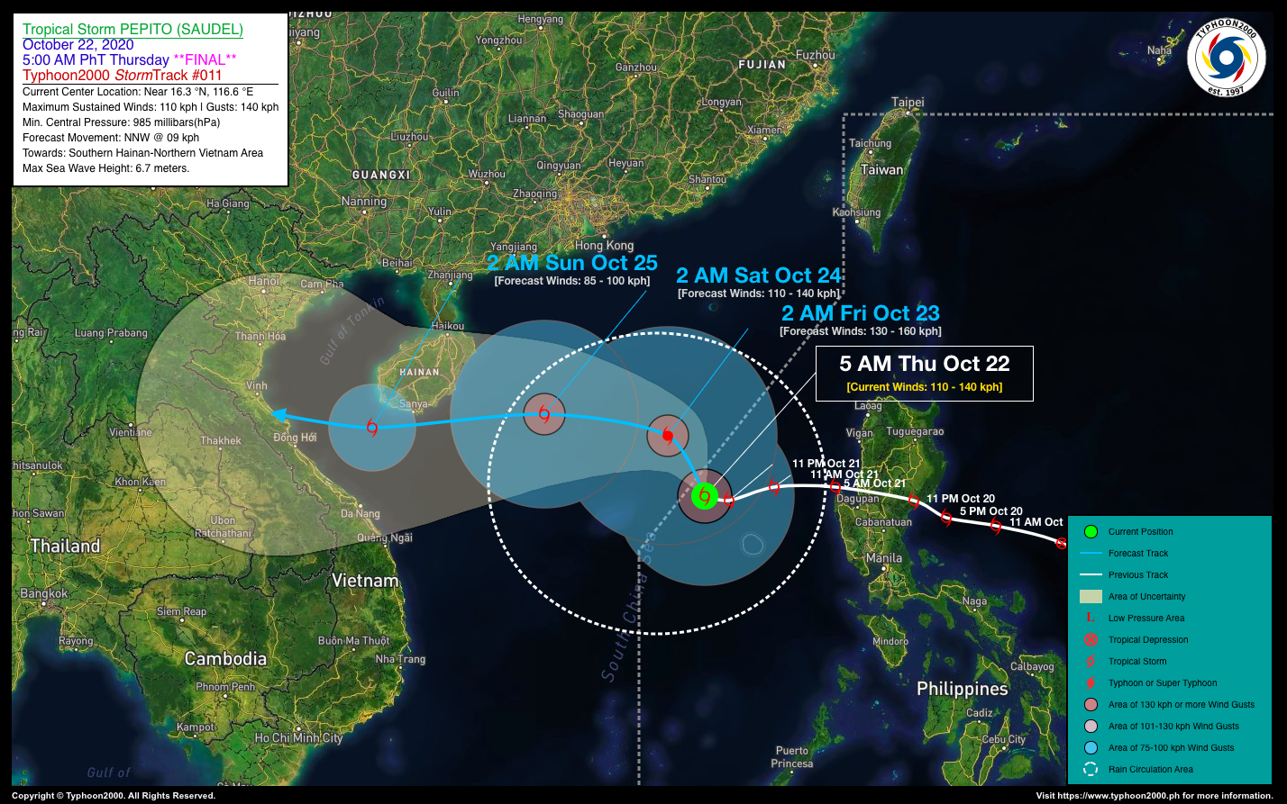
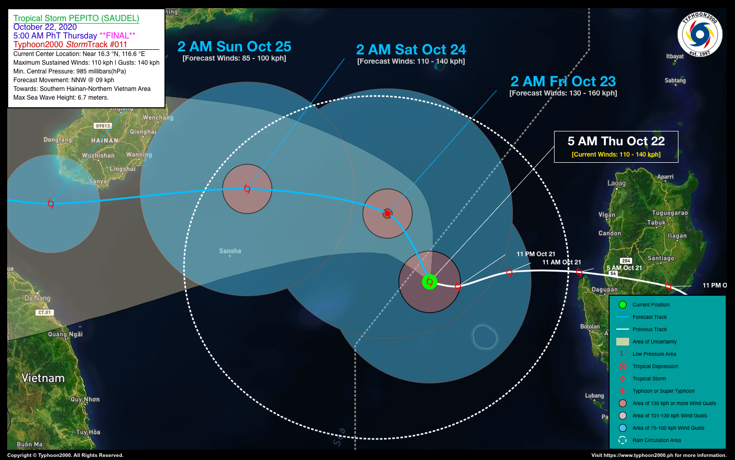
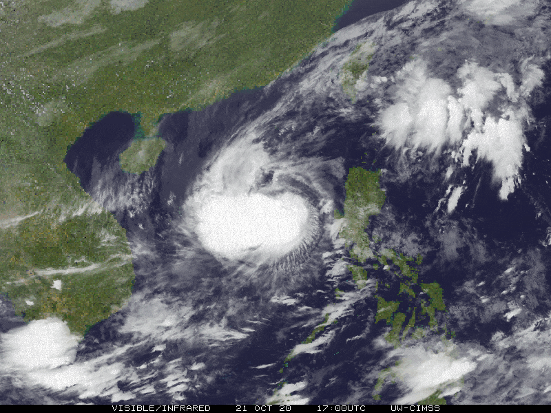
| Current Status and Outlook | Severe Tropical Storm PEPITO (SAUDEL) moving very slowly over the West Philippine Sea as it intensifies further to near Typhoon strength…expected to exit the western border of the Philippine Area of Responsibility (PAR) today.
*This is the Final Advisory on this Tropical Cyclone. 24-hr Outlook: STS PEPITO (SAUDEL) is forecast to move slowly north-northwestward at 09 kph for the next 24 hours and will continue to gain strength, reaching Typhoon classification with winds of 130 km/hr by early Friday morning. |
| Where is PEPITO (SAUDEL)? | As of 5:00 AM PhT Today, October 22…2100 GMT. The center was located over the West Philippine Sea, just northwest of Scarborough (Panatag) Shoal (near 16.3°N 116.6°E), about 362 km west of Alaminos City, Pangasinan or 400 km west of Dagupan City, Pangasinan. |
| How strong is it? | Maximum Sustained Winds (1-min avg): 110 kph near the center…Gustiness: 140 kph. |
| Past Movement (06 hrs) | West @ 11 kph, towards the South China Sea. |
| Potential Philippine Landfall Area(s) | :: None |
| What Philippine areas will be directly affected? | Heavy to Extreme Rains (50 mm to >100 mm expected in 24 hrs): >> None. Damaging Winds (gusts of more than 100 km/hr expected): |
| Potential Storm Surge/Coastal Flooding Areas+ | :: None.
+Waves of 3 meters in height is expected in storm surge-prone areas, particularly in coastal areas on where the Tropical Cyclone is headed. Kindly visit the PAGASA Storm Surge Updates for more details. |
| 2-Day Forecast Outlook Summary** | FRIDAY EARLY MORNING: Intensifies into a Category 1 Typhoon while outside of PAR as it moves NNW slowly across the South China Sea…about 487 km WNW of Alaminos City, Pangasinan [2AM Oct 23: 17.7°N 115.7°E @ 130 kph]. Confidence Level: HIGH
SATURDAY EARLY MORNING: Weakens into an STS as it nears Hainan Island…about 489 km SSW of Hong Kong, China [2AM Oct 24: 18.2°N 112.7°E @ 110 kph]. Confidence Level: MEDIUM **Important Note: Please be reminded that the Forecast Outlook changes every 6 hours, and the Day 2 and 3 Forecast Track have an average error of 100 and 250 km respectively… while the wind speed forecast error, averages 35 km/hr per day. Therefore, a turn to the left or right of its future track and changes in its wind speed must be anticipated from time to time. |
| Other Storm’s Meteorological Info | > 24 hr. Rain Accumulation (across its circulation): 25 to 500 mm [Light to Extreme]
> Minimum Central Pressure: 985 millibars (hPa) > Size of Circulation [Convective Cloud-Based, in diameter]: 675 km (Medium) > Area of Damaging Winds (100 kph or more wind gusts): 70 km from the center. |
| Current Summary/Additional Reference Points | Time/Date: 5:00 AM PhT Thu October 22, 2020 Location of Center/Eye: Near 16.3°N Lat 116.6°E Lon Distance 1: 426 km W of Urdaneta City, Pangasinan Distance 2: 427 km W of Baguio City, Benguet Distance 3: 437 km WNW of Tarlac City, Tarlac Distance 4: 446 km WNW of Angeles City, Pampanga Distance 5: 515 km WNW of Metro Manila |
| Information based on data collected by Typhoon2000 (T2k) shall not be taken as official data. Weather information broadcasted and distributed by PAGASA remains as official data. Typhoon2000 (T2k) shall not be responsible for the private use and reliance of its weather information. | |
Issued by: David Michael V. Padua for Typhoon2000 (T2K)
PAGASA TROPICAL CYCLONE WIND SIGNALS
:: None ::
Screenshot/Image Source: DOST-PAGASA (http://pubfiles.pagasa.dost.


