
TROPICAL DEPRESSION PEPITO ADVISORY NO. 03Issued at: 7:00 PM PhT (11:00 GMT) Monday, 19 October 2020
Next update: 7:00 AM PhT (23:00 GMT) Tuesday, 20 October 2020 |
|
|---|---|
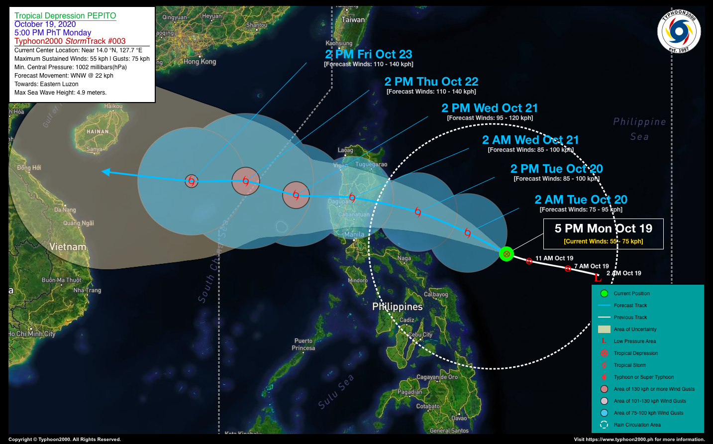
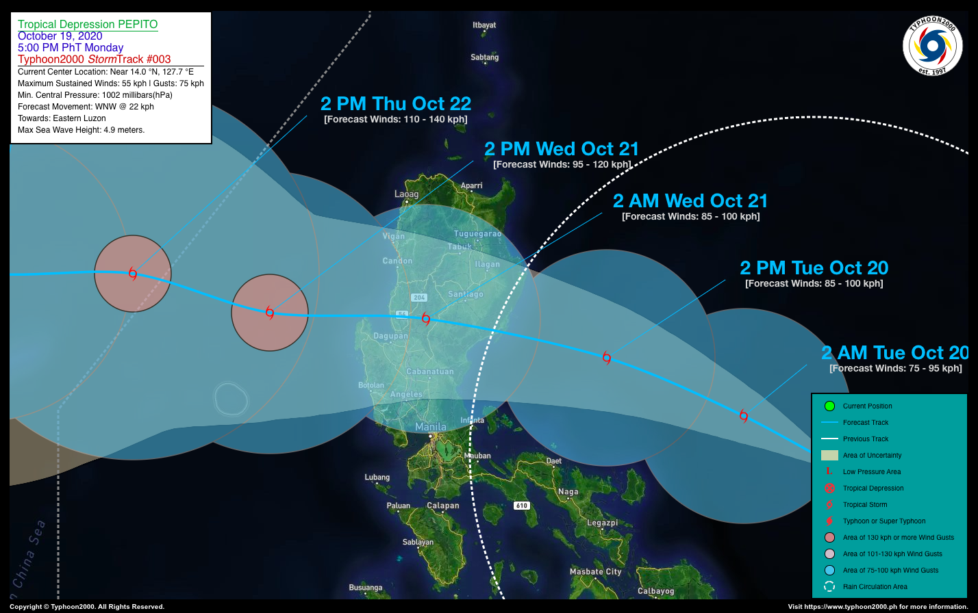
| Current Status and Outlook | Tropical Depression (TD) PEPITO has slowed down as it strengthened slightly during the past 6 hours. Its forecast area of landfall will be somewhere along the east coast of Aurora by late tomorrow evening (Oct 20). Rainy conditions with some gusty winds will be expected across Luzon and portions of MiMaRoPa beginning tomorrow through Wednesday (Oct 21).
24-hr Outlook: TD PEPITO could become a Tropical Storm (TS) later tonight and shall move west-northwestward with an increased forward speed of 22 km/hr. It will be approaching the eastern coastal areas of Aurora tomorrow afternoon, while passing about 250 km north-northeast of Naga City, Camarines Sur at around 2pm. The combination of the Pepito’s Rainbands, Trough and the Enhanced Northeasterly Surface Windflow will bring overcast skies with scattered to widespread “on-&-off” rain showers and thunderstorms across Luzon and Visayas including Northeastern Mindanao today and tomorrow. |
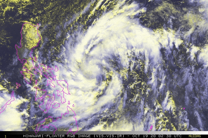
| Where is PEPITO? | As of 5:00 PM PhT today, October 19…0900 GMT. The center was located along the mid-western portion of the Central Philippine Sea (near 14.0°N 127.7°E), about 381 km east of Virac, Catanduanes or 649 km east-southeast of Casiguran, Aurora. |
| How strong is it? | Maximum Sustained Winds (1-min avg): 55 kph near the center…Gustiness: 75 kph. |
| Past Movement (06 hrs) | West-Northwest @ 14 kph, towards Eastern Luzon. |
| Potential Philippine Landfall Area(s) | :: Somewhere along the East Coast of Aurora (between the Towns of San Ildefonso-Dipaculao-Dinalungan-Casiguran Area), between 9 to 11 PM local time tomorrow evening, Tuesday (Oct 20) – with Medium Strike Probability of 50%. |
| What Philippine areas will be directly affected? | Heavy to Extreme Rains (50 mm to >100 mm expected in 24 hrs): >> Quezon, Bicol Region, & Northern Samar – Today through Tuesday Afternoon. Damaging Winds (gusts of more than 100 km/hr expected): |
| Potential Storm Surge/Coastal Flooding Areas+ | :: None.
+Waves of 3 meters in height is expected in storm surge-prone areas, particularly in coastal areas on where the Tropical Cyclone is headed. Kindly visit the PAGASA Storm Surge Updates for more details. |
| 3-Day Forecast Outlook Summary** | TUESDAY AFTERNOON: Strengthens into a TS as it passes well to the north of Bicol Region…about 192 km ESE of Casiguran, Aurora [2PM Oct 20: 15.8°N 123.8°E @ 85 kph]. Confidence Level: LOW
WEDNESDAY AFTERNOON: Becomes a Severe Tropical Storm (STS) as it emerges over the West Philippine Sea after traversing the Southern Part of Northern Luzon…about 174 km WNW of Alaminos City, Pangasinan [2PM Oct 21: 16.5°N 118.4°E @ 95 kph]. Confidence Level: LOW THURSDAY AFTERNOON: Exits the western border of the Philippine Area of Responsibility (PAR) as it continues to intensify while heading towards Vietnam…about 417 km WNW of Alaminos City, Pangasinan [2PM Oct 22: 17.1°N 116.2°E @ 110 kph]. Confidence Level: LOW **Important Note: Please be reminded that the Forecast Outlook changes every 6 hours, and the Day 2 and 3 Forecast Track have an average error of 100 and 250 km respectively… while the wind speed forecast error, averages 35 km/hr per day. Therefore, a turn to the left or right of its future track and changes in its wind speed must be anticipated from time to time. |
| Other Storm’s Meteorological Info | > 24 hr. Rain Accumulation (across its circulation): 25 to 200 mm [Light to Heavy]
> Minimum Central Pressure: 1002 millibars (hPa) > Size of Circulation [Convective Cloud-Based, in diameter]: 1,225 km (Medium) > Area of Damaging Winds (100 kph or more wind gusts): None. |
| Current Summary/Additional Reference Points | Time/Date: 5:00 PM PhT Mon October 19, 2020 Location of Center/Eye: Near 14.0°N Lat 127.7°E Lon Distance 1: 375 km ENE of Catarman, Northern Samar Distance 2: 416 km E of Caramoan, Camarines Sur Distance 3: 438 km ENE of Legazpi City, Albay Distance 4: 489 km E of Naga City, Camarines Sur Distance 5: 718 km E of Metro Manila 24 hr. Forecast Coordinates (Class): 15.8°N 123.8°E (TS) 48 hr. Forecast Coordinates (Class): 16.5°N 118.4°E (STS) |
| Information based on data collected by Typhoon2000 (T2k) shall not be taken as official data. Weather information broadcasted and distributed by PAGASA remains as official data. Typhoon2000 (T2k) shall not be responsible for the private use and reliance of its weather information. | |
Issued by: David Michael V. Padua for Typhoon2000 (T2K)
PAGASA TROPICAL CYCLONE WIND SIGNAL
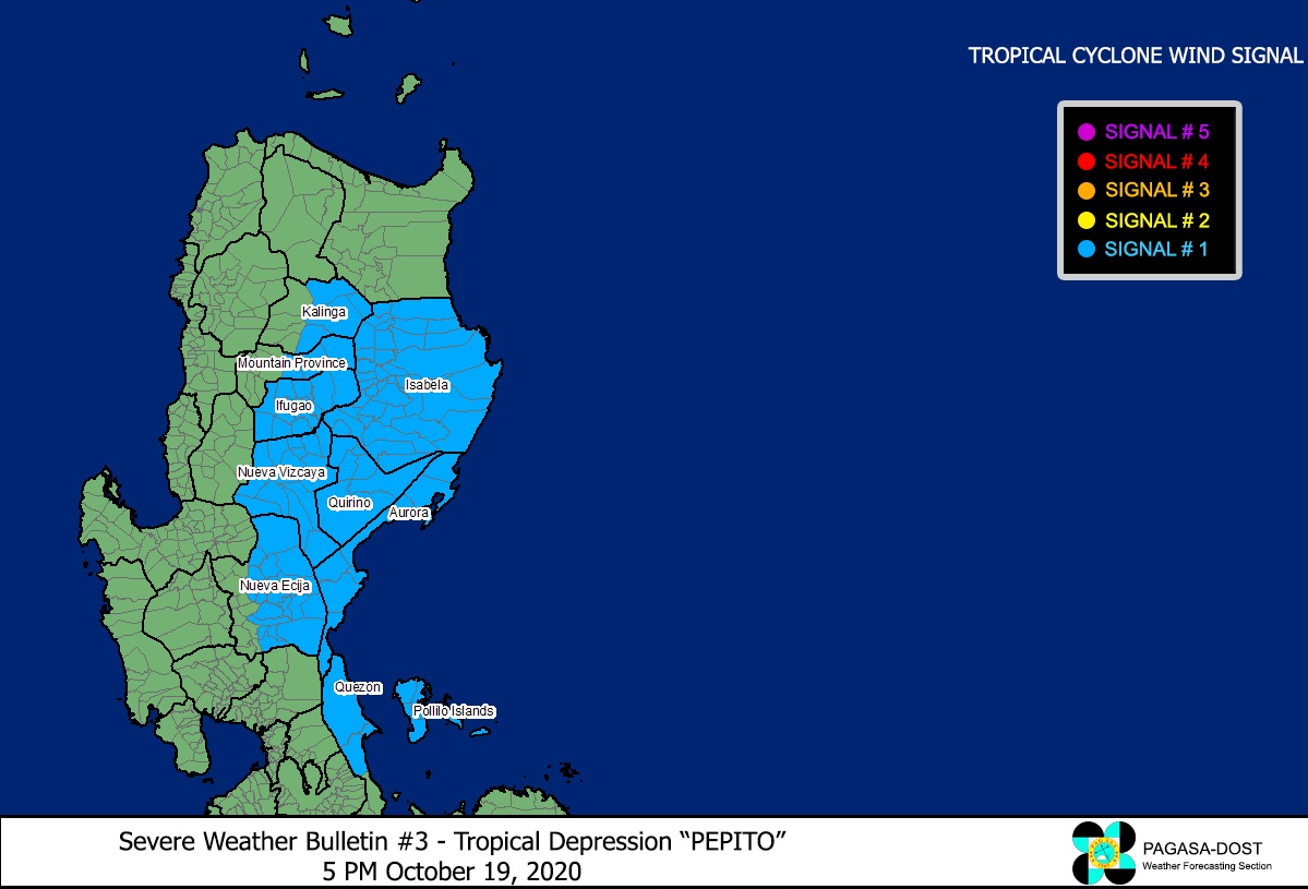
Image Source: DOST-PAGASA (http://pubfiles.pagasa.dost.


