

SEVERE TROPICAL STORM JOLINA (CONSON) ADVISORY NO. 08Issued at: 1:00 PM PhT (05:00 GMT) Wednesday, 08 September 2021
Next update: 7:00 PM PhT (11:00 GMT) Wednesday, 08 September 2021 |
|
|---|---|
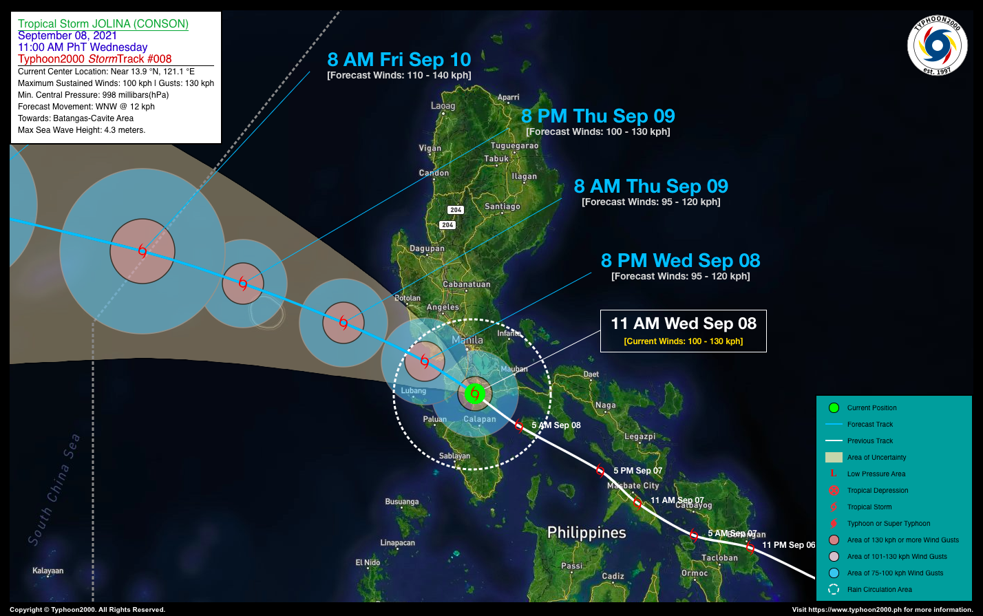
| Current Status & Outlook | Severe Tropical Storm JOLINA (CONSON) is now moving across Batangas passing over Taal-Tagaytay Area…approaching Magallanes-Silang Area. The storm made landfall around 9 AM this morning in San Juan, Batangas. Stormy Weather will continue to prevail across CaLaBaRZon, NCR and the Southern Sections of Central Luzon.
24-hr Outlook: STS JOLINA (CONSON) is forecast to weaken slightly and will track WNW-ward slowly at 12 km/hr through tomorrow morning. Later this evening, the storm will emerge along the mouth of Manila Bay and will pass very close to Bataan. By tomorrow morning, JOLINA will emerge over the West Philippine Sea as it moves closer to Scarborough Shoal. Meanwhile, Typhoon KIKO (CHANTHU) has been tracking WSW across the Philippine Sea during the past 6 hours. At 11 AM today, the eye was located about 1,050 km East of Casiguran, Aurora (15.8N 131.8E), with 1-min sustained winds of 230 kph with higher gusts. This system is not yet a threat to any part of the country as it is forecast to move towards Extreme Northern Luzon-Taiwan Area within the next 3 days. |
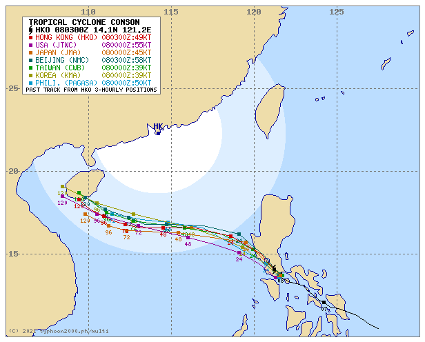
| Where is JOLINA (CONSON)? | As of 11:00 AM PhT today, September 08…0300 GMT:
|
| How strong is it? | Maximum Sustained Winds (1-min avg): 100 kph near the center…Gustiness: 130 kph. |
| Past Movement (06 hrs) | Northwest @ 15 kph, towards Cavite. |
| Potential Philippine Landfall Area(s) |
|
| What Philippine areas will be directly affected? | Heavy to Extreme Rainfall (50 mm to >100 mm expected for 24 hrs):
Damaging Winds (gusts of more than 100 km/hr expected):
|
| Potential Storm Surge/Coastal Flooding Areas+ |
+Waves of 3 meters in height is expected in storm surge-prone areas, particularly in coastal areas on where the Tropical Cyclone is headed. Kindly visit the PAGASA Storm Surge Updates for more details. |
| 2-Day Forecast Outlook Summary** |
**Important Note: Please be reminded that the Forecast Outlook changes every 6 hours, and the Day 2 and 3 Forecast Track have an average error of 100 and 250 km respectively… while the wind speed forecast error, averages 35 km/hr per day. Therefore, a turn to the left or right of its future track and changes in its wind speed must be anticipated from time to time. |
| Other Storm’s Meteorological Information |
|
| Information based on data collected by Typhoon2000 (T2k) shall not be taken as official data. Weather information broadcasted and distributed by PAGASA remains as official data. Typhoon2000 (T2k) shall not be responsible for the private use and reliance of its weather information. | |
Issued by: David Michael V. Padua for Typhoon2000 (T2K)
Typhoon2000 (T2K) Integrated Multi-Agency Tracks
PAGASA TROPICAL CYCLONE WIND SIGNAL
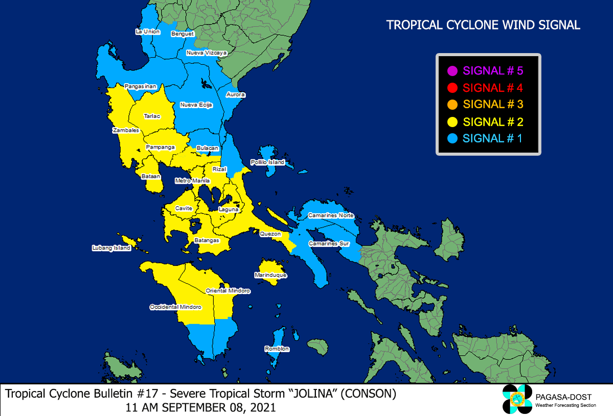
Image/Screenshot Source: DOST-PAGASA (http://bagong.pagasa.dost.gov.ph/tropical-cyclone-bulletin-iframe)


