


TROPICAL STORM JOLINA (CONSON) ADVISORY NO. 06Issued at: 7:00 PM PhT (11:00 GMT) Tuesday, 07 September 2021
Next update: 7:00 AM PhT (23:00 GMT) Wednesday, 08 September 2021 |
|
|---|---|
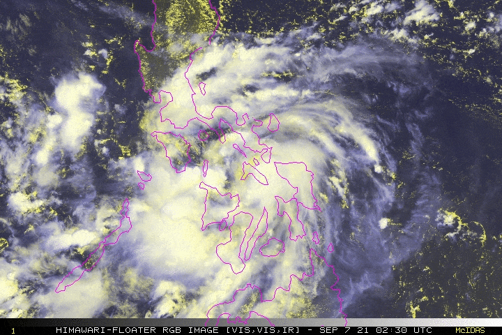
| Current Status & Outlook | JOLINA (CONSON) has weakened into a Tropical Storm (TS) after traversing Masbate…now emerges over the Sibuyan Sea, passing very close to the southern part of Burias Island.
24-hr Outlook: TS JOLINA (CONSON) is forecast to maintain its strength and will move northwestward at a decreased forward speed of 12 km/hr. By early morning tomorrow, JOLINA will move across Tayabas Bay and could make landfall over Marinduque before sunrise tomorrow. Then, a second landfall is likely over Batangas-Southern Quezon Area around noon time and will be in the vicinity of Tiaong, Quezon tomorrow afternoon. Meanwhile, CHANTHU rapidly intensified into a Typhoon and has entered the Philippine Area of Responsibility (PAR), with local name “KIKO”. At 7PM today, the eye was located about 1,379 km East of Casiguran, Aurora (16.3N 134.9E), with 1-min sustained winds of 120 kph with higher gusts. This system is not a threat to any part of the country as it is forecast to move towards Batanes-Taiwan Area within the next 5 days. |
| Where is JOLINA (CONSON)? | As of 5:00 PM PhT today, September 07…0900 GMT:
|
| How strong is it? | Maximum Sustained Winds (1-min avg): 85 kph near the center…Gustiness: 100 kph. |
| Past Movement (06 hrs) | Northwest @ 14 kph, towards Marinduque-CaLaBaRZon Area |
| Potential Philippine Landfall Area(s) |
|
| What Philippine areas will be directly affected? | Heavy to Extreme Rainfall (50 mm to >100 mm expected for 24 hrs):
Damaging Winds (gusts of more than 100 km/hr expected):
|
| Potential Storm Surge/Coastal Flooding Areas+ |
+Waves of 3 meters in height is expected in storm surge-prone areas, particularly in coastal areas on where the Tropical Cyclone is headed. Kindly visit the PAGASA Storm Surge Updates for more details. |
| 3-Day Forecast Outlook Summary** |
**Important Note: Please be reminded that the Forecast Outlook changes every 6 hours, and the Day 2 and 3 Forecast Track have an average error of 100 and 250 km respectively… while the wind speed forecast error, averages 35 km/hr per day. Therefore, a turn to the left or right of its future track and changes in its wind speed must be anticipated from time to time. |
| Other Storm’s Meteorological Information |
|
| Information based on data collected by Typhoon2000 (T2k) shall not be taken as official data. Weather information broadcasted and distributed by PAGASA remains as official data. Typhoon2000 (T2k) shall not be responsible for the private use and reliance of its weather information. | |
Issued by: David Michael V. Padua for Typhoon2000 (T2K)
Typhoon2000 (T2K) Integrated Multi-Agency Tracks
PAGASA TROPICAL CYCLONE WIND SIGNAL
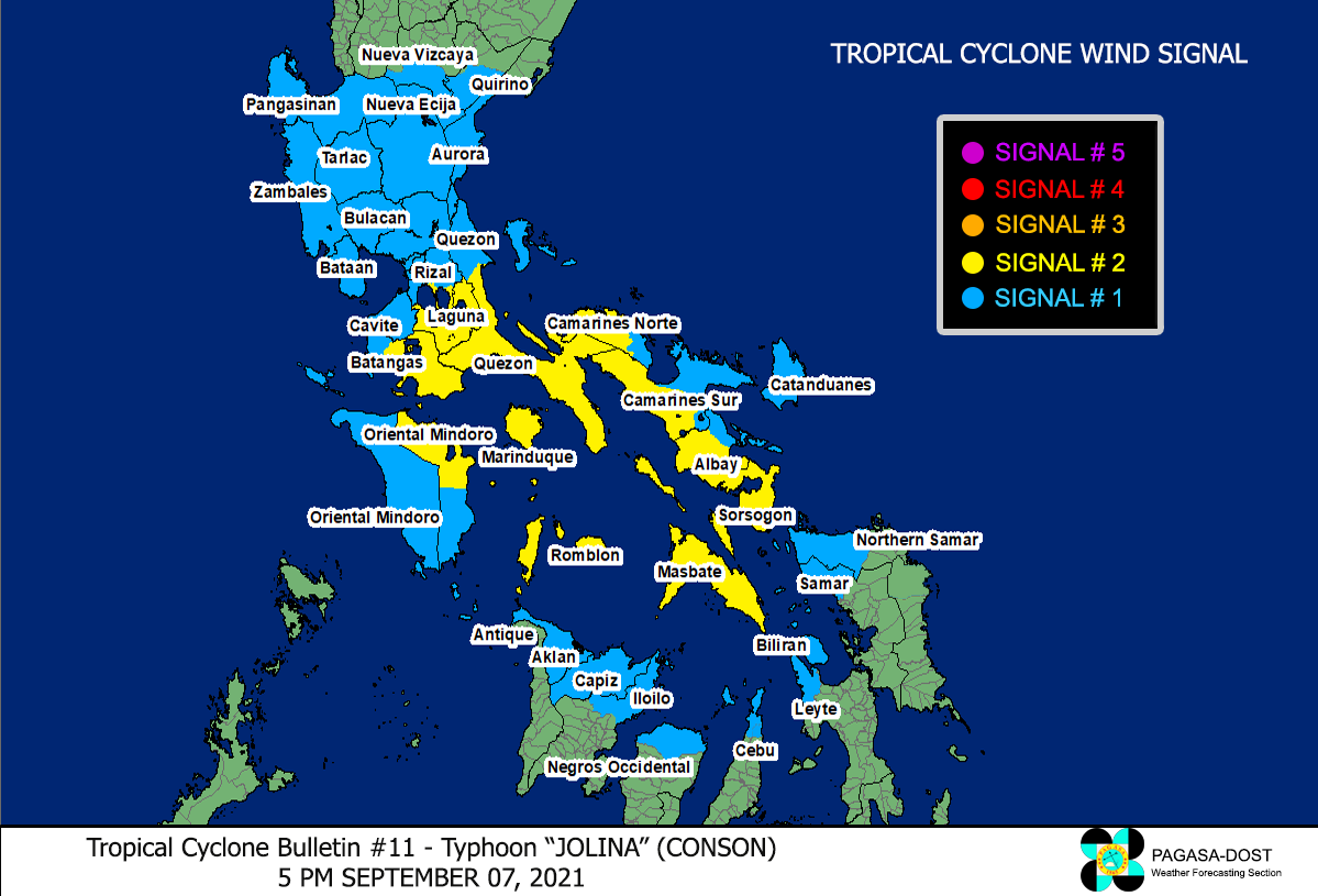
Image/Screenshot Source: DOST-PAGASA (http://bagong.pagasa.dost.gov.ph/tropical-cyclone-bulletin-iframe)


