
TYPHOON JENNY (KOINU) ADVISORY NO. 10Issued at: 2:00 AM PhT (18:00 GMT) Thursday, 05 Oct 2023
Next update: 2:00 PM PhT (06:00 GMT) Thursday, 05 Oct 2023 |
|
|---|---|
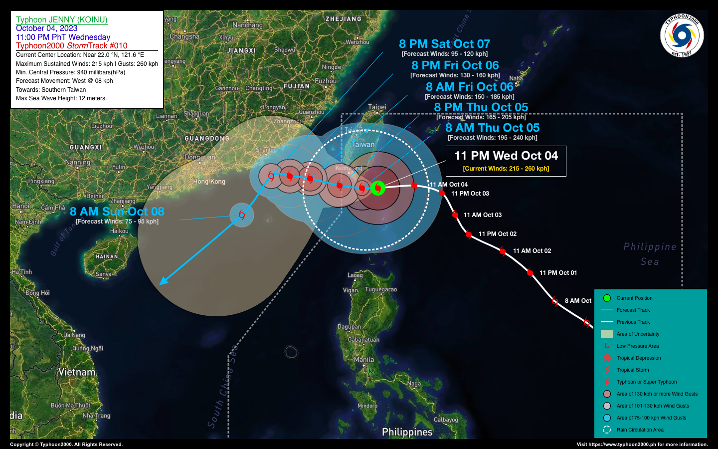
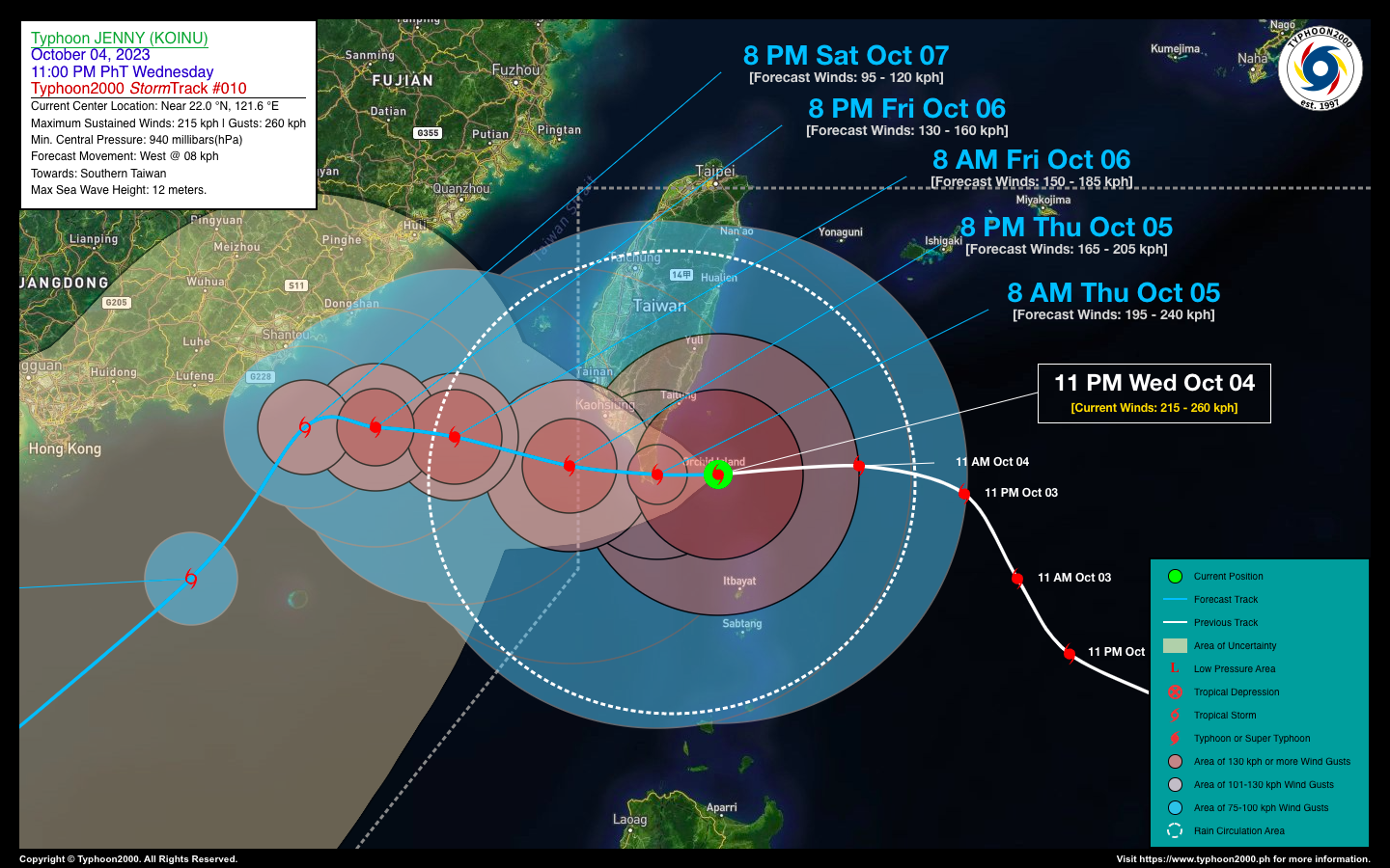
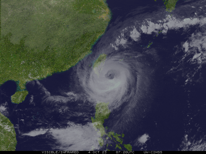
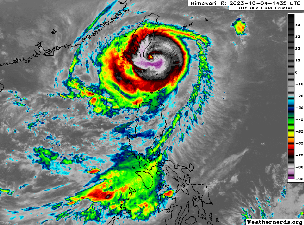
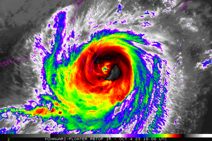
| Current Status & Outlook | Typhoon JENNY (KOINU) made an “Islandfall” over the Island of Lanyu around 10-11pm last night. Maximum Sustained Winds (1-min average) maintained at 215 km/hr, gusting up to 260 km/hr. Its inner southern rainbands continue to affect the Batanes Group of Islands.
48-hr Outlook: TY JENNY is forecast to make landfall over the southern tip of Taiwan (or along Pingtung Province) within the next 6 hours. Then, emerging later over the southernmost portion of Taiwan Strait, as it moves out of the Philippine Area of Responsibility (PAR) late this afternoon or tonight. On Friday evening, JENNY will gradually weaken into a Category 1 Typhoon while approaching the coastal waters of Eastern Guangdong due to the after-effects of Taiwan’s landmass on its circulation, increasing upper-level winds and decreasing Oceanic Heat Content (OHC). Meanwhile, the presence of TY JENNY’s Outer Rainbands and the Southwest Monsoon (Habagat) will continue to bring overcast skies with isolated to scattered to at times occasional rain showers and severe thunderstorms across Northern Luzon and the western sections of Central & Southern Luzon incl. NCR, Mindoro, & Calamian Group today. It will be more frequent during the afternoon or evening. Please take all necessary precautions against flash floods and landslides incl. lahars that will be brought about by these systems. |
| Where is JENNY (KOINU)? | As of 11:00 PM PhT last night, October 04…1500 GMT:
|
| How strong is it? | Maximum Sustained Winds (1-min avg): 215 kph near the center…Gustiness: 260 kph. |
| Past Movement (06 hrs) | West @ 14 kph, towards the Southern Tip of Taiwan. |
| Potential Philippine Major Landfall Area(s) |
|
| What Philippine areas will be directly affected? | Heavy to Extreme Rainfall (50 mm to >100 mm expected for 24 hrs):
Damaging Winds (gusts of more than 100 km/hr expected):
|
| Potential Storm Surge/Coastal Flooding Areas+ |
+Waves of greater than 2 meters in height are expected in storm surge-prone areas, particularly in coastal areas where the Tropical Cyclone is headed. Kindly visit the PAGASA Storm Surge Updates for more details. |
| 2-Day Forecast Outlook Summary** |
**Important Note: Please be reminded that the Forecast Outlook changes every 6 hours, and the Day 2 and 3 Forecast Track have an average error of 100 and 250 km respectively… while the wind speed forecast error, averages 35 km/hr per day. Therefore, a turn to the left or right of its future track and changes in its wind speed must be anticipated from time to time. |
| Other Storm’s Meteorological Information |
|
| Disclaimer: Information based on data collected by Typhoon2000 (T2k) shall not be taken as official data. Weather information broadcasted and distributed by PAGASA remains as official data. Typhoon2000 (T2k) shall not be responsible for the private use and reliance of its weather information. | |
Issued by: David Michael V. Padua for Typhoon2000 (T2k)
Typhoon2000 (T2K) Integrated Multi-Agency Tracks

For more info visit: (http://www.typhoon2000.ph/multi/?name=KOINU)
PAGASA TROPICAL CYCLONE WIND SIGNAL
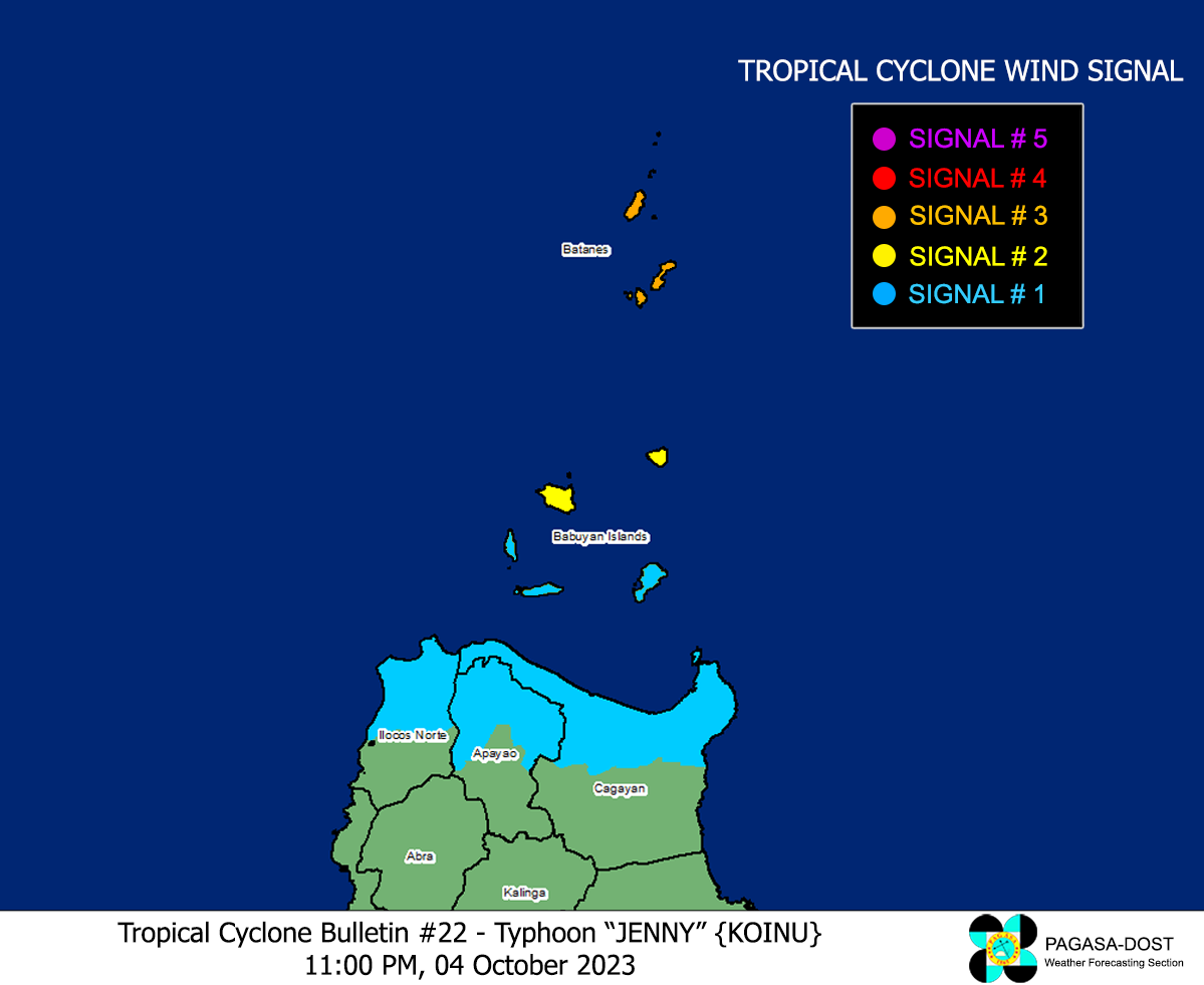
Image/Screenshot Source: DOST-PAGASA (https://bagong.pagasa.dost.gov.ph/tropical-cyclone/severe-weather-bulletin)


