

TROPICAL STORM CRISING ADVISORY NO. 02Issued at: 7:00 PM PhT (11:00 GMT) Thursday, 13 May 2021
Next update: 1:00 AM PhT (17:00 GMT) Friday, 14 May 2021 |
|
|---|---|
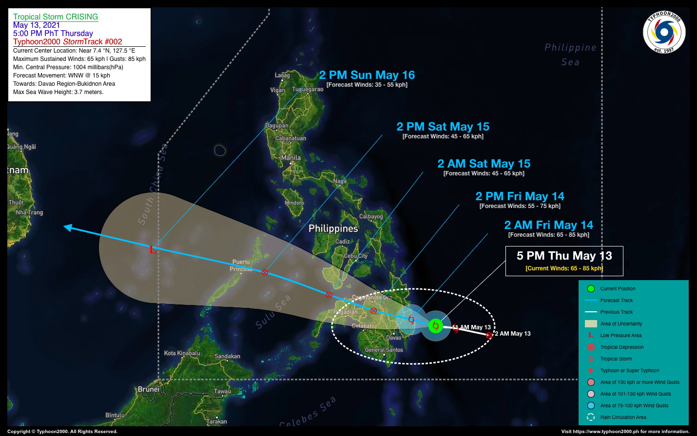
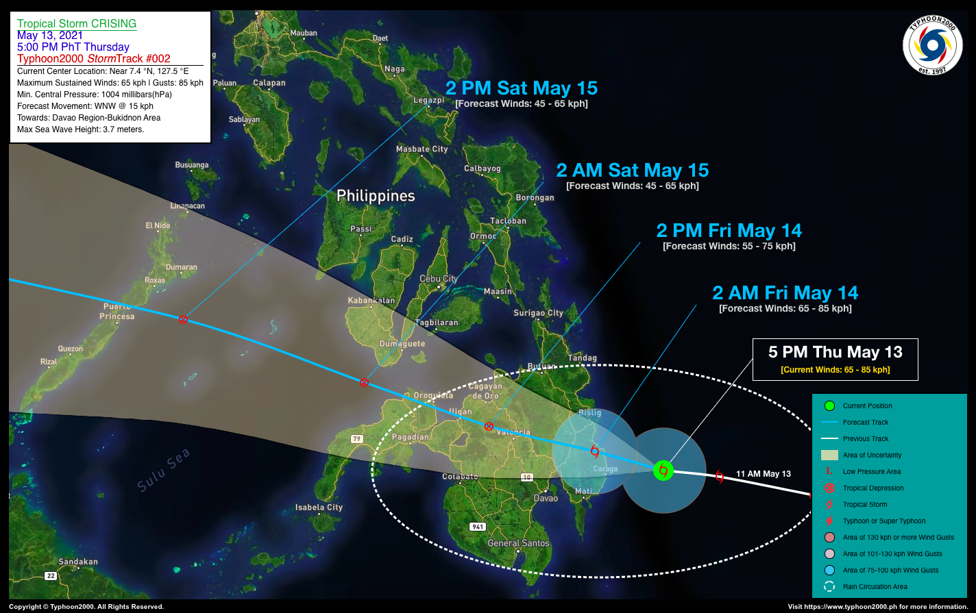
| Current Status & Outlook | Tropical Storm (TS) CRISING has become slightly disorganized while moving closer to Davao Region, but maintained its strength during the past 06 hours. Landfall expected along Davao Oriental by early tomorrow morning.
This storm will bring scattered to occasional rains with severe thunderstorms and gusty winds across Eastern, Central & Northern Mindanao particularly Davao Region and portions of Caraga Region today through tomorrow (Fri). 24-hr Outlook: TS CRISING is forecast to move west to west-northwestward across the coastal waters of Davao Oriental at a forward speed of 15 km/hr, while maintaining its strength prior in making landfall. After making landfall over the coastline of Davao Oriental early tomorrow morning, TS CRISING is expected to weaken into a Tropical Depression (TD) as it moves across the landmass of Mindanao, and traverse Davao De Oro and Del Norte by mid-morning tomorrow, and shall be in the vicinity of Bukidnon by tomorrow afternoon. |
| Where is Crising? | As of 5:00 PM PhT today, May 13…0900 GMT:
|
| How strong is it? | Maximum Sustained Winds (1-min avg): 65 kph near the center…Gustiness: 85 kph. |
| Past Movement (06 hrs) | West @ 17 kph, towards Davao Region. |
| Potential Philippine Landfall Area(s) |
|
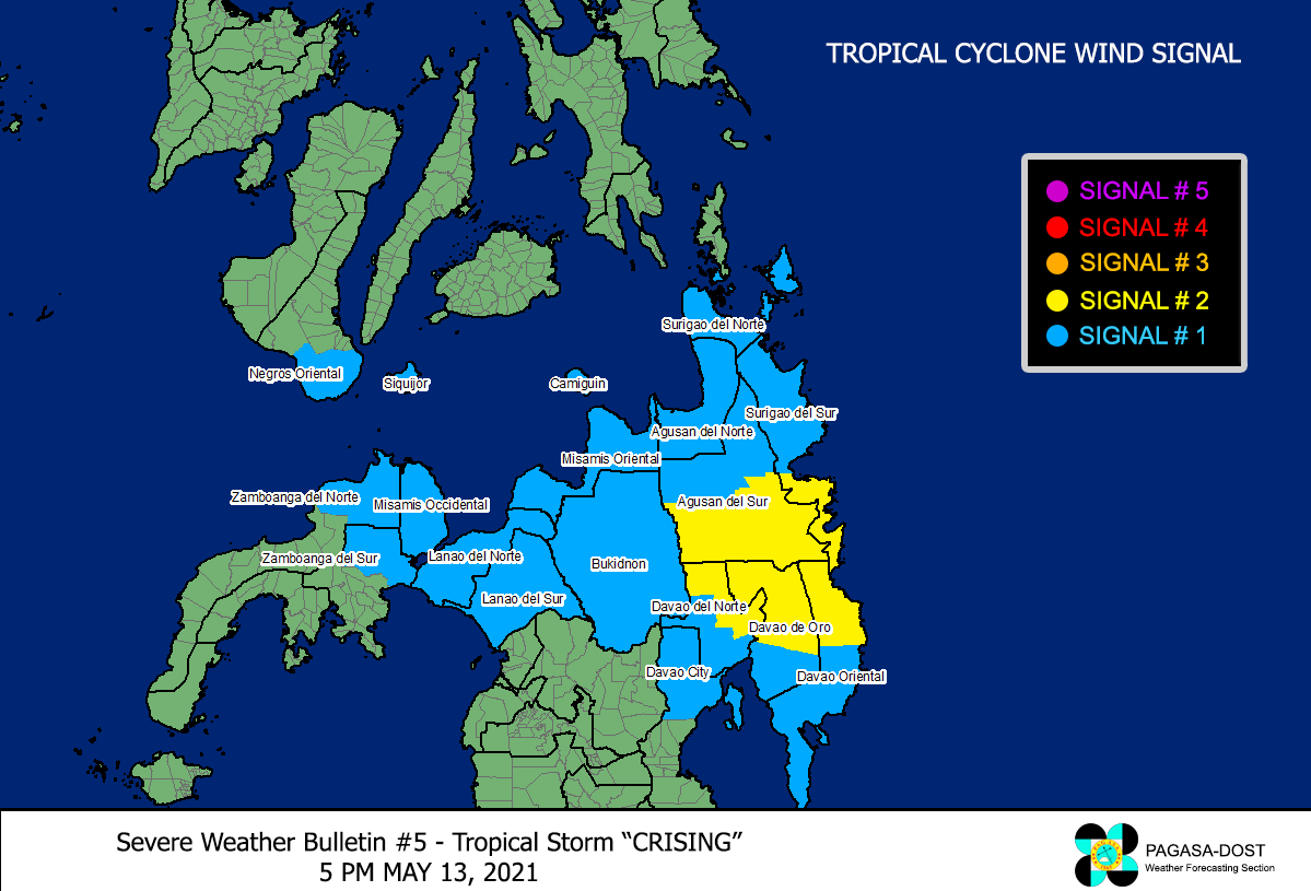
| What Philippine areas will be directly affected? | Heavy to Extreme Rainfall (50 mm to >100 mm expected for 24 hrs):
Damaging Winds (gusts of more than 100 km/hr expected):
|
| Potential Storm Surge/Coastal Flooding Areas+ |
+Waves of 3 meters in height is expected in storm surge-prone areas, particularly in coastal areas on where the Tropical Cyclone is headed. Kindly visit the PAGASA Storm Surge Updates for more details. |
| 3-Day Forecast Outlook Summary** |
**Important Note: Please be reminded that the Forecast Outlook changes every 6 hours, and the Day 2 and 3 Forecast Track have an average error of 100 and 250 km respectively… while the wind speed forecast error, averages 35 km/hr per day. Therefore, a turn to the left or right of its future track and changes in its wind speed must be anticipated from time to time. |
| Other Storm’s Meteorological Information |
|
| Information based on data collected by Typhoon2000 (T2k) shall not be taken as official data. Weather information broadcasted and distributed by PAGASA remains as official data. Typhoon2000 (T2k) shall not be responsible for the private use and reliance of its weather information. | |
Issued by: David Michael V. Padua for Typhoon2000 (T2K)
Typhoon2000 (T2K) Integrated Multi-Agency Tracks
:: None yet. Will be available once RSMC’s Tokyo Typhoon Center (JMA) upgrades it into a Tropical Storm ::
PAGASA TROPICAL CYCLONE WIND SIGNAL
Image/Screenshot Source: DOST-PAGASA (http://pubfiles.pagasa.dost.


