


TROPICAL DEPRESSION AMANG ADVISORY NO. 01Issued at: 11:00 AM PhT (03:00 GMT) Tuesday, 11 April 2023
Next update: 11:00 PM PhT (15:00 GMT) Tuesday, 11 April 2023 |
|
|---|---|
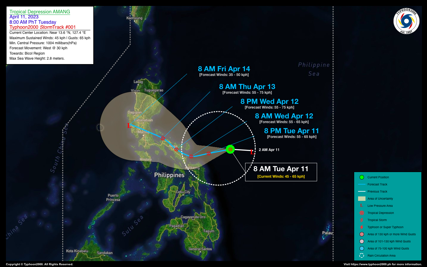
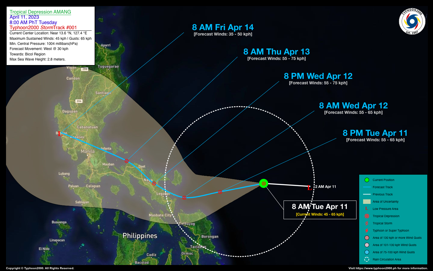
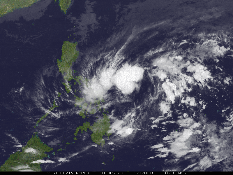
| Current Status & Outlook | Tropical Depression (TD) AMANG newly-formed over the Philippine Sea, fast approaching the eastern coastal waters of Samar and Bicol Provinces. Heavy rains and thunderstorms are expected across the area beginning today and tomorrow (Apr 12).
48-hr Outlook: TD AMANG is forecast to slightly intensify as it approaches Bicol Peninsula. The system will make landfall over Catanduanes-Albay-Camarines Provinces tomorrow and will traverse the area through the evening. By Thursday morning (Apr 13), AMANG will emerge along the NW Coast of Camarines Norte and weaken. |
| Where is AMANG? | As of 8:00 AM PhT today, April 11…0000 GMT:
|
| How strong is it? | Maximum Sustained Winds (1-min avg): 45 kph near the center…Gustiness: 65 kph. |
| Past Movement (06 hrs) | West @ 30 kph, towards the Bicol Region. |
| Potential Philippine Major Landfall Area(s) |
|
| What Philippine areas will be directly affected? | Heavy to Extreme Rainfall (50 mm to >100 mm expected for 24 hrs):
Damaging Winds (gusts of more than 100 km/hr expected):
|
| Potential Storm Surge/Coastal Flooding Areas+ |
+Waves of 3 meters in height are expected in storm surge-prone areas, particularly in coastal areas where the Tropical Cyclone is headed. Kindly visit the PAGASA Storm Surge Updates for more details. |
| 3-Day Forecast Outlook Summary** |
**Important Note: Please be reminded that the Forecast Outlook changes every 6 hours, and the Day 2 and 3 Forecast Track have an average error of 100 and 250 km respectively… while the wind speed forecast error, averages 35 km/hr per day. Therefore, a turn to the left or right of its future track and changes in its wind speed must be anticipated from time to time. |
| Other Storm’s Meteorological Information |
|
| Disclaimer: Information based on data collected by Typhoon2000 (T2k) shall not be taken as official data. Weather information broadcasted and distributed by PAGASA remains as official data. Typhoon2000 (T2k) shall not be responsible for the private use and reliance of its weather information. | |
Issued by: David Michael V. Padua for Typhoon2000 (T2k)
Typhoon2000 (T2K) Integrated Multi-Agency Tracks
:: Not Yet Available
PAGASA TROPICAL CYCLONE WIND SIGNAL

Image/Screenshot Source: DOST-PAGASA (https://bagong.pagasa.dost.gov.ph/tropical-cyclone/severe-weather-bulletin)


