
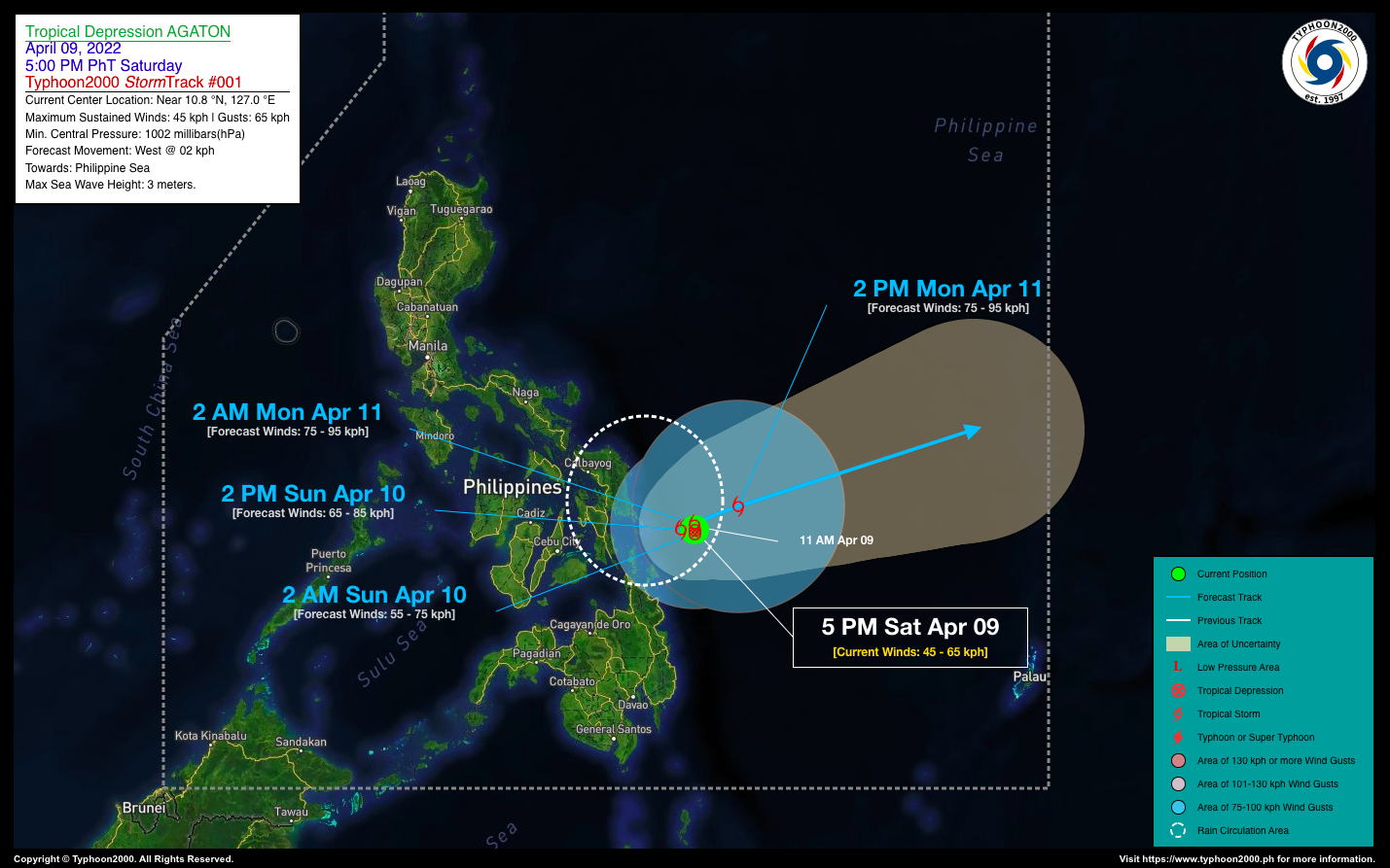

TROPICAL DEPRESSION AGATON ADVISORY NO. 01Issued at: 8:00 PM PhT (12:00 GMT) Saturday, 09 April 2022
Next update: 7:00 AM PhT (23:00 GMT) Sunday, 10 April 2022 |
|
|---|---|
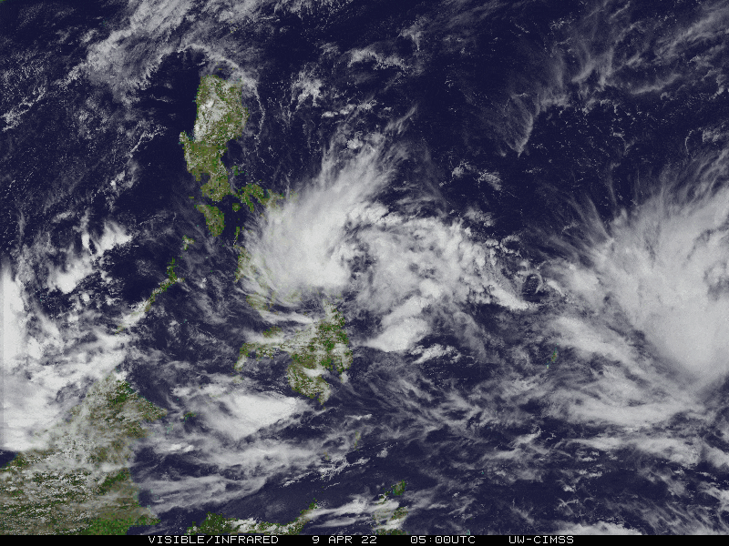
| Current Status & Outlook | Tropical Depression AGATON newly-formed along the coastal waters of Siargao-Guiuan Area…barely moving as it awaits the passage of the much stronger Tropical Storm MALAKAS located to the east, outside of the Philippine Area of Responsibility (PAR).
24-hr Outlook: TD AGATON is forecast to maintain its quasi-stationary motion through tomorrow, Sunday and could become a Tropical Storm. Its circulation remains small and will only affect Eastern Visayas and Surigao Del Norte including Siargao and Dinagat Island Group. |
| Where is AGATON? | As of 5:00 PM PhT today, April 09…0900 GMT:
|
| How strong is it? | Maximum Sustained Winds (1-min avg): 45 kph near the center…Gustiness: 65 kph. |
| Past Movement (06 hrs) | Quasi-Stationary (ESE @ 04 kph), over the Coastal Waters of Siargao-Guiuan Area. |
| Potential Philippine Major Landfall Area(s) |
|
| What Philippine areas will be directly affected? | Heavy to Extreme Rainfall (50 mm to >100 mm expected for 24 hrs):
Damaging Winds (gusts of more than 100 km/hr expected):
|
| Potential Storm Surge/Coastal Flooding Areas+ |
+Waves of 3 meters in height are expected in storm surge-prone areas, particularly in coastal areas where the Tropical Cyclone is headed. Kindly visit the PAGASA Storm Surge Updates for more details. |
| 3-Day Forecast Outlook Summary** |
**Important Note: Please be reminded that the Forecast Outlook changes every 6 hours, and the Day 2 and 3 Forecast Track have an average error of 100 and 250 km respectively… while the wind speed forecast error, averages 35 km/hr per day. Therefore, a turn to the left or right of its future track and changes in its wind speed must be anticipated from time to time. |
| Other Storm’s Meteorological Information |
|
| Information based on data collected by Typhoon2000 (T2k) shall not be taken as official data. Weather information broadcasted and distributed by PAGASA remains as official data. Typhoon2000 (T2k) shall not be responsible for the private use and reliance of its weather information. | |
Issued by: David Michael V. Padua for Typhoon2000 (T2k)
Typhoon2000 (T2K) Integrated Multi-Agency Tracks
:: Not Yet Available
PAGASA TROPICAL CYCLONE WIND SIGNAL
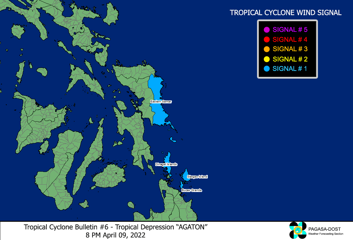
Image/Screenshot Source: DOST-PAGASA (http://bagong.pagasa.dost.gov.ph/tropical-cyclone-bulletin-iframe)


