
TROPICAL STORM EMONG (CO-MAY) ADVISORY NO. 01Issued at: 2:00 AM PhT (18:00 GMT) Thursday, 24 Jul 2025
Next update: 2:00 PM PhT (06:00 GMT) Thursday, 24 Jul 2025 |
|
|---|---|
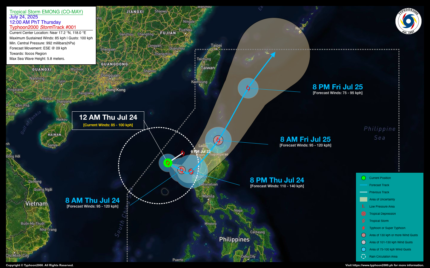
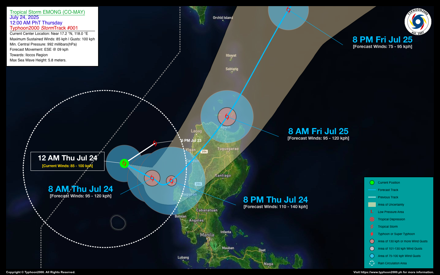
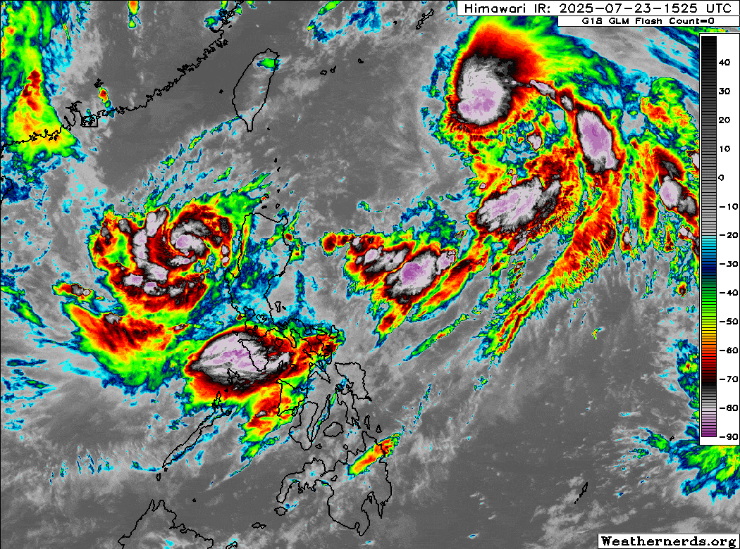
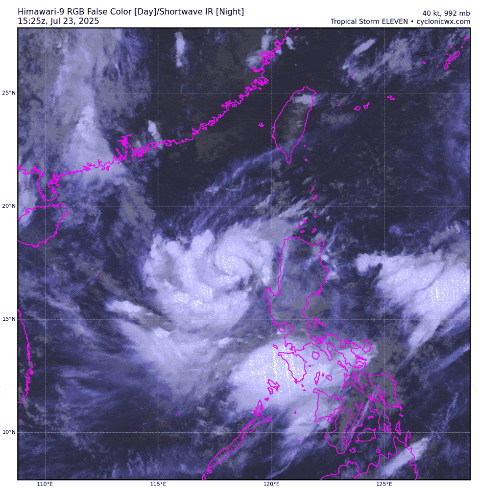
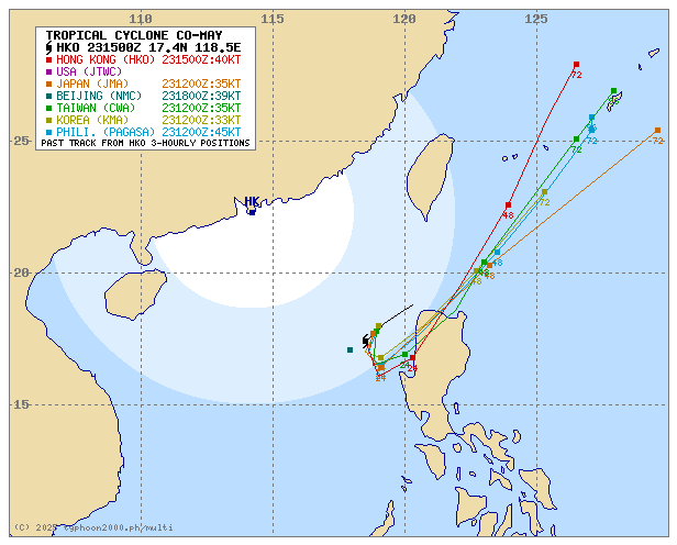
| Current Status & Outlook | The small but active LPA 99W, which crossed Babuyan and Calayan Islands Tuesday evening, quickly intensified into a Tropical Depression yesterday morning and became Tropical Storm EMONG (international name Co-may) in the afternoon. Now undergoing rapid intensification, EMONG may reach Severe Tropical Storm status today. It is forecast to make a counter-clockwise turn toward the Ilocos Region, with possible landfall over the La Union–Ilocos Sur area late tonight or early Friday (July 25). Coastal residents are urged to take necessary precautions.
48-hr Outlook: Tropical Storm EMONG is expected to make landfall over the Ilocos Region early Friday morning and is likely to peak as a Severe Tropical Storm before landfall. By Friday evening, EMONG will weaken into a minimal Tropical Storm as it accelerates northward over the East Taiwan Sea. Meanwhile, the combined presence of Tropical Storms EMONG and DANTE will continue to enhance the Southwest Monsoon (Habagat), bringing intermittent light to moderate, and at times heavy to torrential rainfall across the western sections of the country—including MIMAROPA, Western Luzon, Western Visayas, and the western portions of Bicol—today and tomorrow. |
| Where is EMONG (CO-MAY)? | As of 12:00 AM PhT today, Jul 24…1600 GMT:
|
| How strong is it? | Maximum Sustained Winds (1-min avg): 85 kph near the center…Gustiness: 100 kph. |
| Past Movement (06 hrs) | Southwest @ 24 kph, towards Ilocos Region. |
| Potential Philippine Major Landfall Area(s) |
|
| What Philippine areas will be directly affected? | Heavy to Extreme Rainfall (50 mm to >100 mm expected for 24 hrs):
Damaging Winds (gusts of more than 100 km/hr expected):
|
| Potential Storm Surge/Coastal Flooding Areas+ |
+Waves of 1 to 2 meters in height are expected in storm surge-prone areas, particularly in coastal areas where the Tropical Cyclone is headed. Kindly visit the PAGASA Storm Surge Updates for more details. |
| 2-Day Forecast Outlook Summary** |
**Important Note: Please be reminded that the Forecast Outlook changes every 6 hours, and the Day 2 and 3 Forecast Track have an average error of 100 and 250 km respectively… while the wind speed forecast error, averages 35 km/hr per day. Therefore, a turn to the left or right of its future track and changes in its wind speed must be anticipated from time to time. |
| Other Storm’s Meteorological Information |
|
| Disclaimer: Information provided by 𝗧𝘆𝗽𝗵𝗼𝗼𝗻𝟮𝟬𝟬𝟬 (𝗧𝟮𝗸) is for general reference only and should not be considered official. For authoritative weather updates, please refer to DOST-PAGASA. T2k is not liable for any decisions made based on the use of its weather information. | |
Issued by: David Michael V. Padua for Typhoon2000 (T2k)
Typhoon2000 (T2K) Integrated Multi-Agency Tracks
For more info visit: (http://www.typhoon2000.ph/multi/?name=CO-MAY)
PAGASA TROPICAL CYCLONE WIND SIGNAL
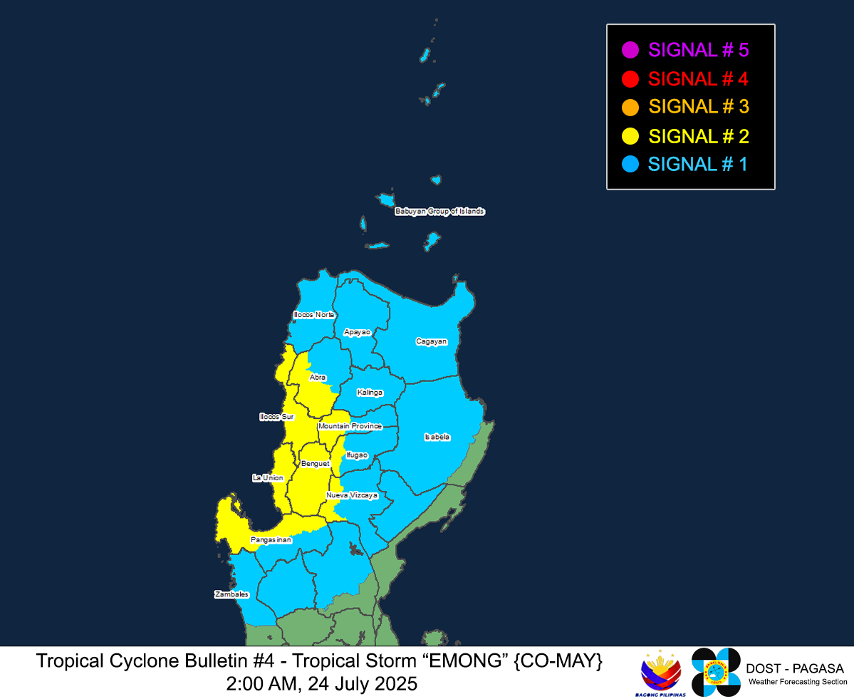
Image/Screenshot Source: DOST-PAGASA (https://www.pagasa.dost.gov.ph/tropical-cyclone/severe-weather-bulletin)


