
TROPICAL DEPRESSION CRISING ADVISORY NO. 02Issued at: 11:00 PM PhT (15:00 GMT) Thursday, 17 Jul 2025
Next update: 11:00 AM PhT (03:00 GMT) Friday, 18 Jul 2025 |
|
|---|---|
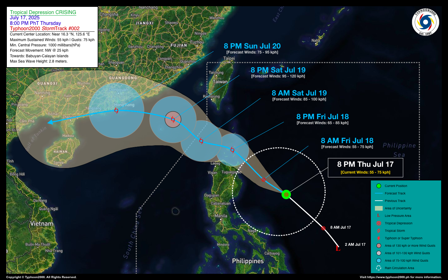
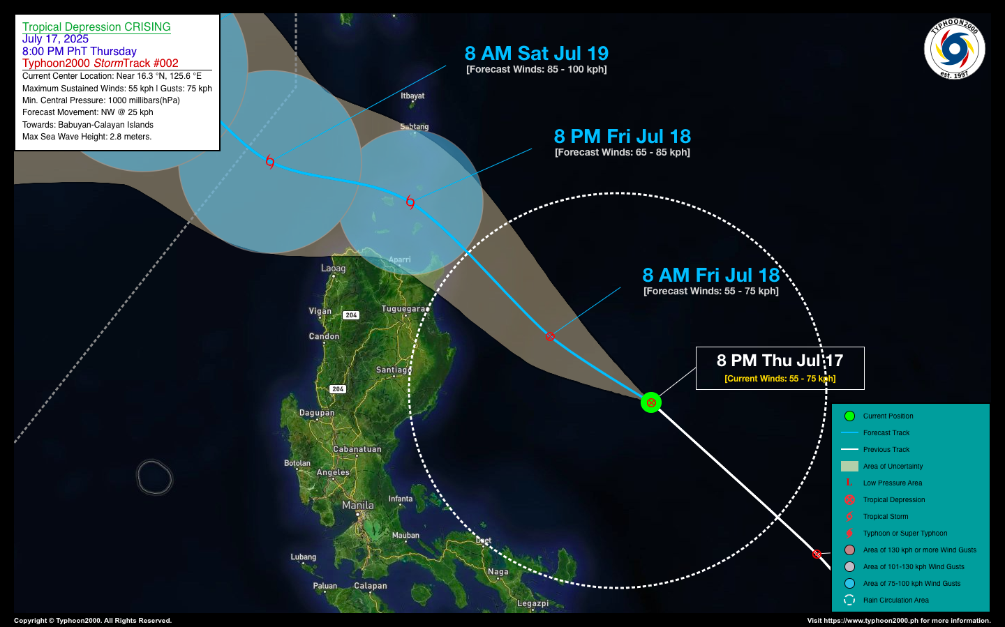
| Current Status & Outlook | Tropical Depression CRISING has been tracking northwestward over the past 12 hours, maintaining its strength as it heads toward the Northern Cagayan-Babuyan area. Residents in flood- and landslide-prone areas of Northern Luzon are advised to remain vigilant due to the potential for heavy to torrential rainfall associated with this system..
48-hr Outlook: TD CRISING is expected to continue moving northwest toward Extreme Northern Luzon, possibly passing through the Balintang Channel and over Calayan Island by tomorrow evening (July 18). It is forecast to intensify into a Tropical Storm before traversing the channel. By Saturday evening, CRISING is projected to exit the Philippine Area of Responsibility (PAR) as it moves in the direction of the Hong Kong area. The presence of CRISING will enhance the Southwest Monsoon (Habagat), bringing occasional light to moderate, and at times heavy to torrential rains across the western sections of the country—including MIMAROPA, Western Mindanao, the Visayas, and Western Luzon—starting today and continuing through the weekend. |
| Where is CRISING? | As of 8:00 PM PhT today, Jul 17…1200 GMT:
|
| How strong is it? | Maximum Sustained Winds (1-min avg): 55 kph near the center…Gustiness: 75 kph. |
| Past Movement (06 hrs) | Northwest @ 36 kph, towards Extreme Northern Luzon. |
| Potential Philippine Major Landfall Area(s) |
|
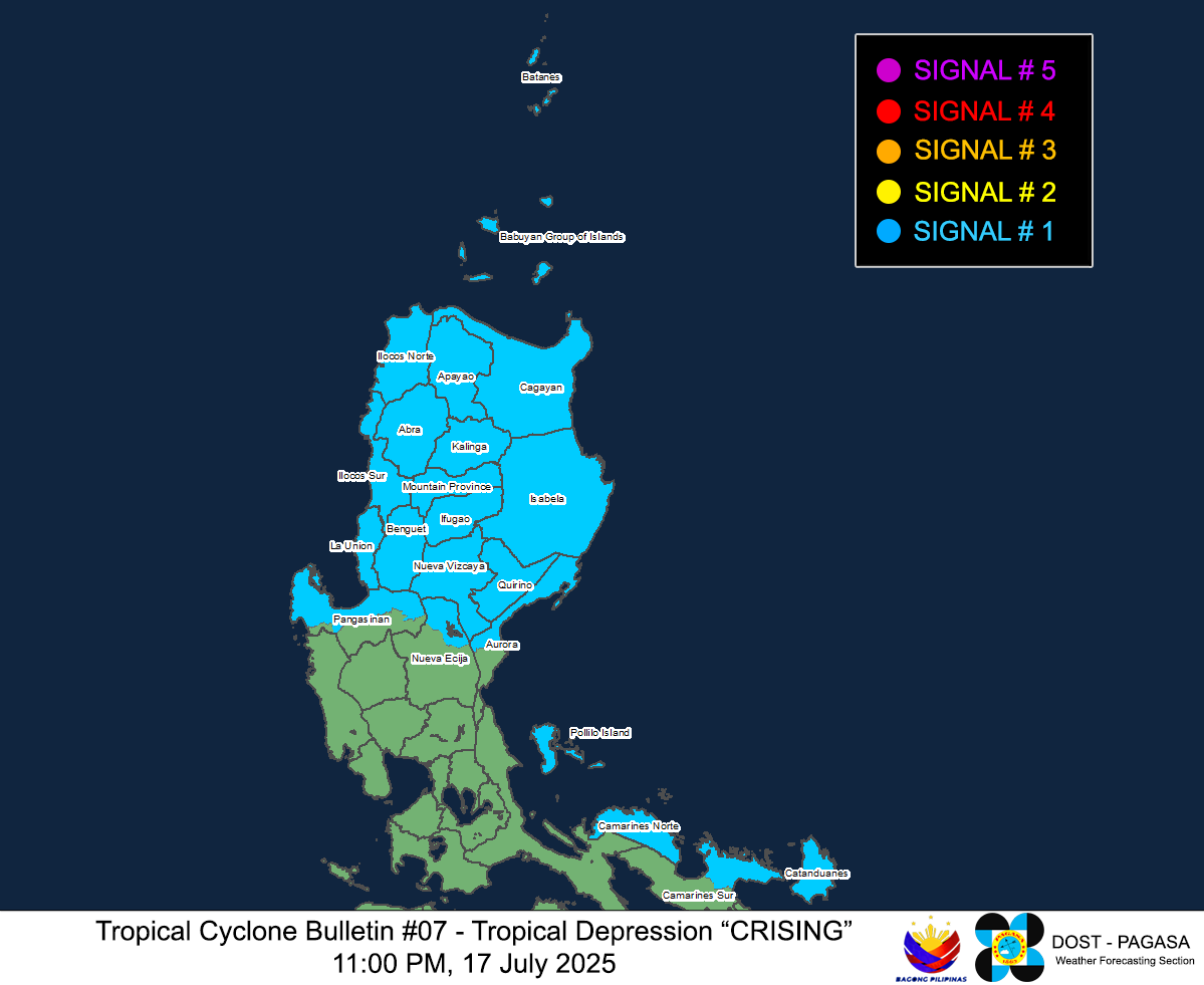
| What Philippine areas will be directly affected? | Heavy to Extreme Rainfall (50 mm to >100 mm expected for 24 hrs):
Damaging Winds (gusts of more than 100 km/hr expected):
|
| Potential Storm Surge/Coastal Flooding Areas+ |
+Waves of more than 3 meters in height are expected in storm surge-prone areas, particularly in coastal areas where the Tropical Cyclone is headed. Kindly visit the PAGASA Storm Surge Updates for more details. |
| 3-Day Forecast Outlook Summary** |
**Important Note: Please be reminded that the Forecast Outlook changes every 6 hours, and the Day 2 and 3 Forecast Track have an average error of 100 and 250 km respectively… while the wind speed forecast error, averages 35 km/hr per day. Therefore, a turn to the left or right of its future track and changes in its wind speed must be anticipated from time to time. |
| Other Storm’s Meteorological Information |
|
| Disclaimer: Information based on data collected by Typhoon2000 (T2k) shall not be taken as official data. Weather information broadcasted and distributed by PAGASA remains as official data. Typhoon2000 (T2k) shall not be responsible for the private use and reliance of its weather information. | |
Issued by: David Michael V. Padua for Typhoon2000 (T2k)
PAGASA TROPICAL CYCLONE WIND SIGNAL
Image/Screenshot Source: DOST-PAGASA (https://www.pagasa.dost.gov.ph/tropical-cyclone/severe-weather-bulletin)


