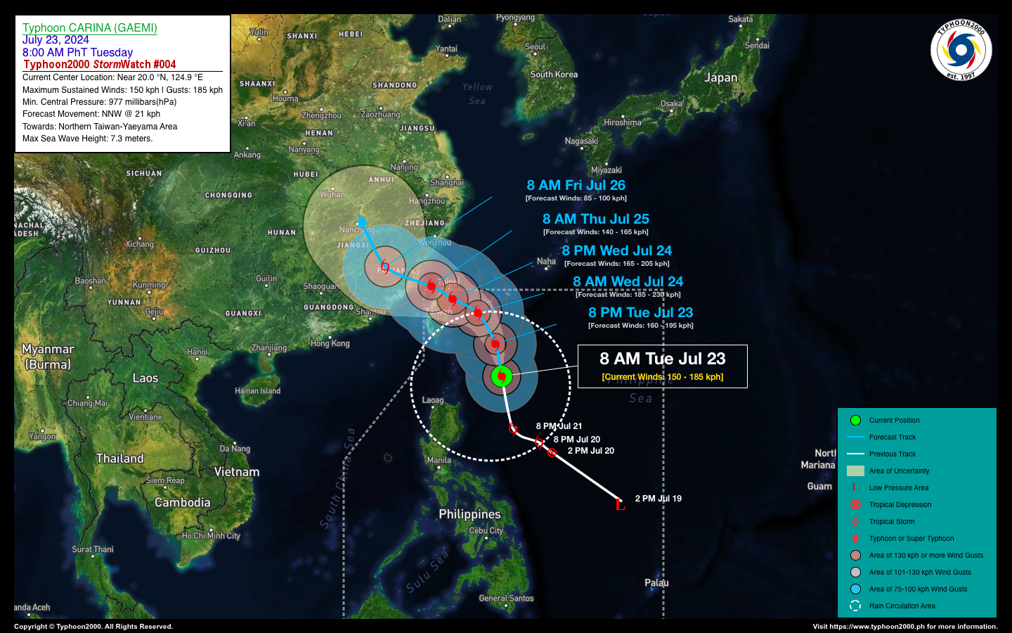
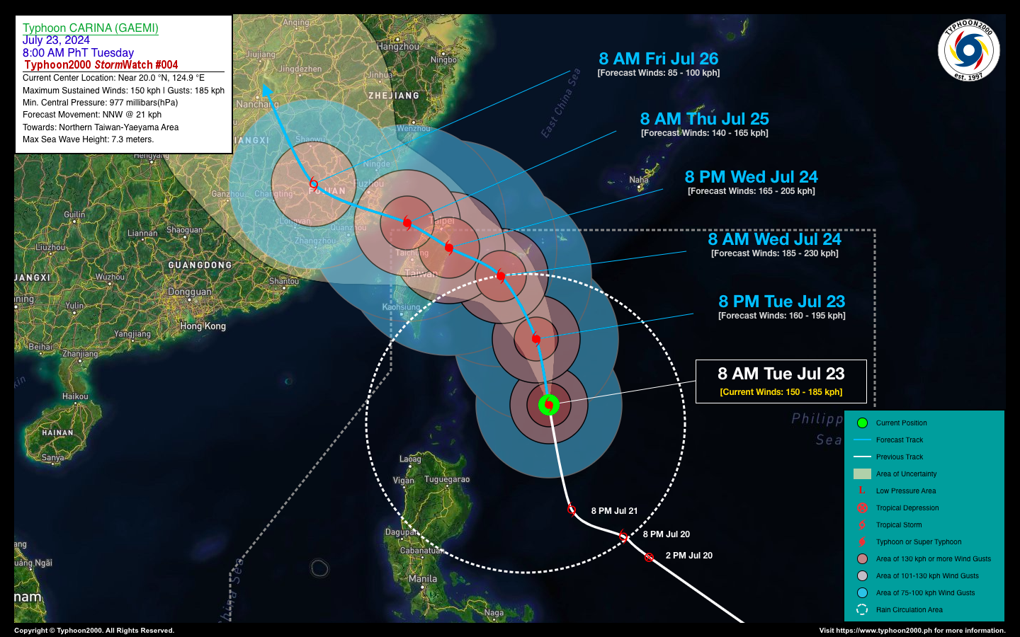
TYPHOON CARINA (GAEMI) STORMWATCH NO. 04

Issued at: 12:00 PM PhT (04:00 GMT) Tuesday, 23 Jul 2024
Next update: 12:00 PM PhT (04:00 GMT) Wednesday, 24 Jul 2024
Current Status and Outlook

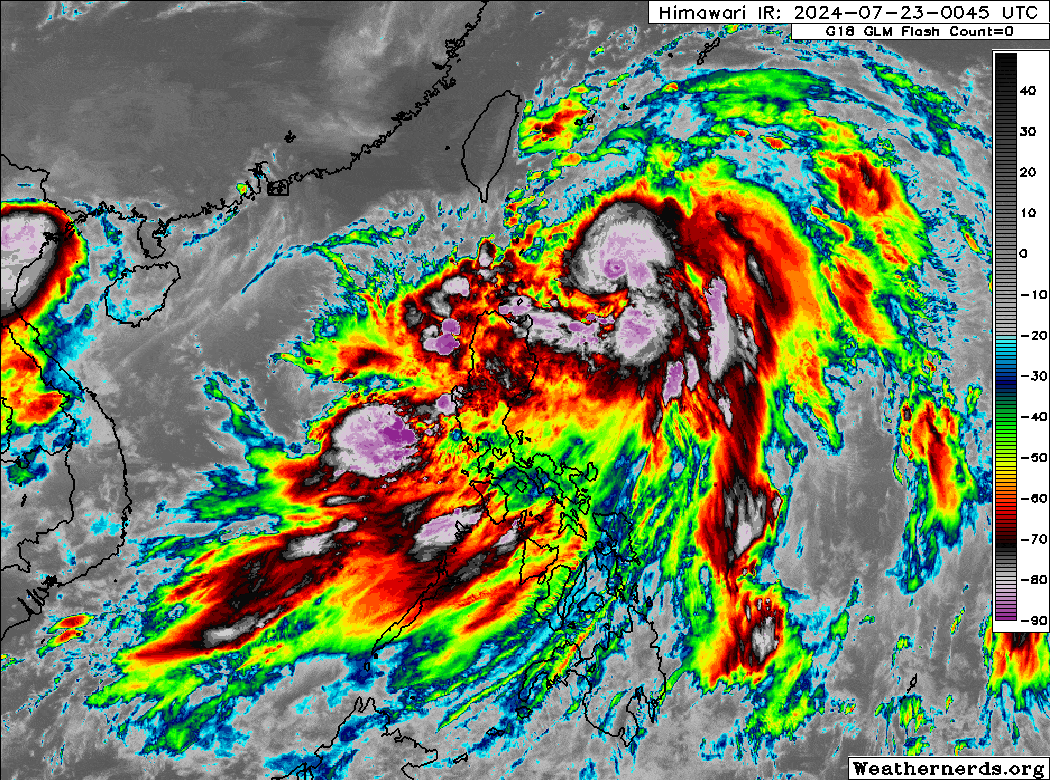
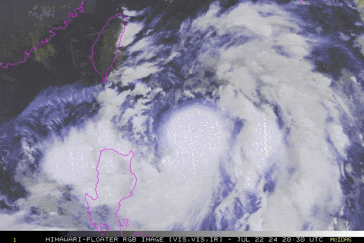
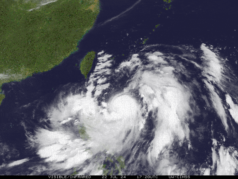
Severe Tropical Storm CARINA (GAEMI) has intensified into a Typhoon with 1-minute sustained winds of 150 km/hr. It has accelerated northward over the past 12 hours and now threatens Taiwan as its wide rainband circulation continues to spread across Northern Luzon.

In the next 24 to 36 hours, Typhoon Carina is expected to veer west-northwest due to a strengthening high-pressure ridge to the north. Landfall over Northern Taiwan is anticipated by tomorrow evening, July 24th. The typhoon is likely to reach Category 3 strength before making landfall, with estimated sustained winds of 185 km/hr.

Where is CARINA (GAEMI)? As of 8:00 AM PhT today, July 23…0000 GMT:

  • Location of Eye/Center: Over the western edge of the North Philippine Sea (near 20.0°N 124.9°E)
  • Distance 1: 305 km east of Basco, Batanes
  • Distance 2: 730 km northeast of Metro Manila
How strong is it? Maximum Sustained Winds (1-min avg): 150 kph near the center…Gustiness: 185 kph.
Past Movement (06 hrs) North @ 30 kph, towards Northern Taiwan
Forecast Highlights
  • TY CARINA (GAEMI) is expected to reach its peak intensity of 185 kph (Category 1) prior in making landfall over Northern Taiwan by tomorrow, Wednesday evening (Jul 24).
  • The Day 2 to 4 Forecast shows Carina emerging over the Taiwan Strait, after traversing the mountains of Northern Taiwan on Thursday morning (Jul 25). By Thursday afternoon, the core of the typhoon will make its final landfall over Fujian Province in Southeastern China, and will rapidly weaken as it moves inland across the mountainous terrain of SE China. On Friday morning (Jul 26), Carina will start to breakdown and weaken into a Tropical Storm on Friday morning (Jul 26) while moving across Nanchang, China. 
  • TY CARINA is forecast to exit the northwestern border of PAR on Thursday morning (Jul 25). 
  • PAGASA has raised TC Wind Signals No. 01 and 02 along the northern and eastern portions of Cagayan Valley.  Please see the attached PAGASA Wind Signal Graphic below.
  • The rainbands of TY CARINA and the Southwest Monsoon (Habagat) will continue to bring occasional (“On-&-Off”) monsoon rains with severe thunderstorms across Northern Luzon and the Western Sections of the country (from Ilocos Region, CAR, Western Parts of Central & Southern Luzon, down to MiMaRoPa, Bicol Region, Western Visayas, & Sulu Archipelago) today until Thursday, Jul 25. 
  • The risk of flooding and landslides during the onset of the monsoon will remain high.
This StormWatch is valid for the next 24 hours.

Information based on data collected by Typhoon2000 (T2k) shall not be taken as official data. Weather information broadcasted and distributed by PAGASA remains as official data. Typhoon2000 (T2k) shall not be responsible for the private use and reliance of its weather information.

o

Typhoon2000 (T2K) Integrated Multi-Agency Tracks


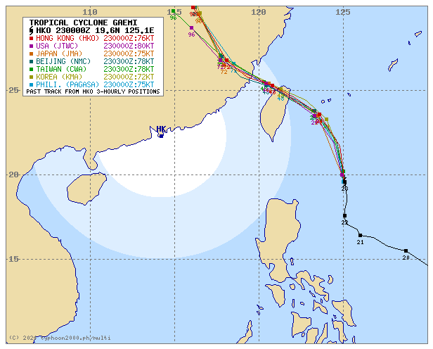
For more info visit: (http://www.typhoon2000.ph/multi/?name=GAEMI)

o

PAGASA TROPICAL CYCLONE WIND SIGNAL


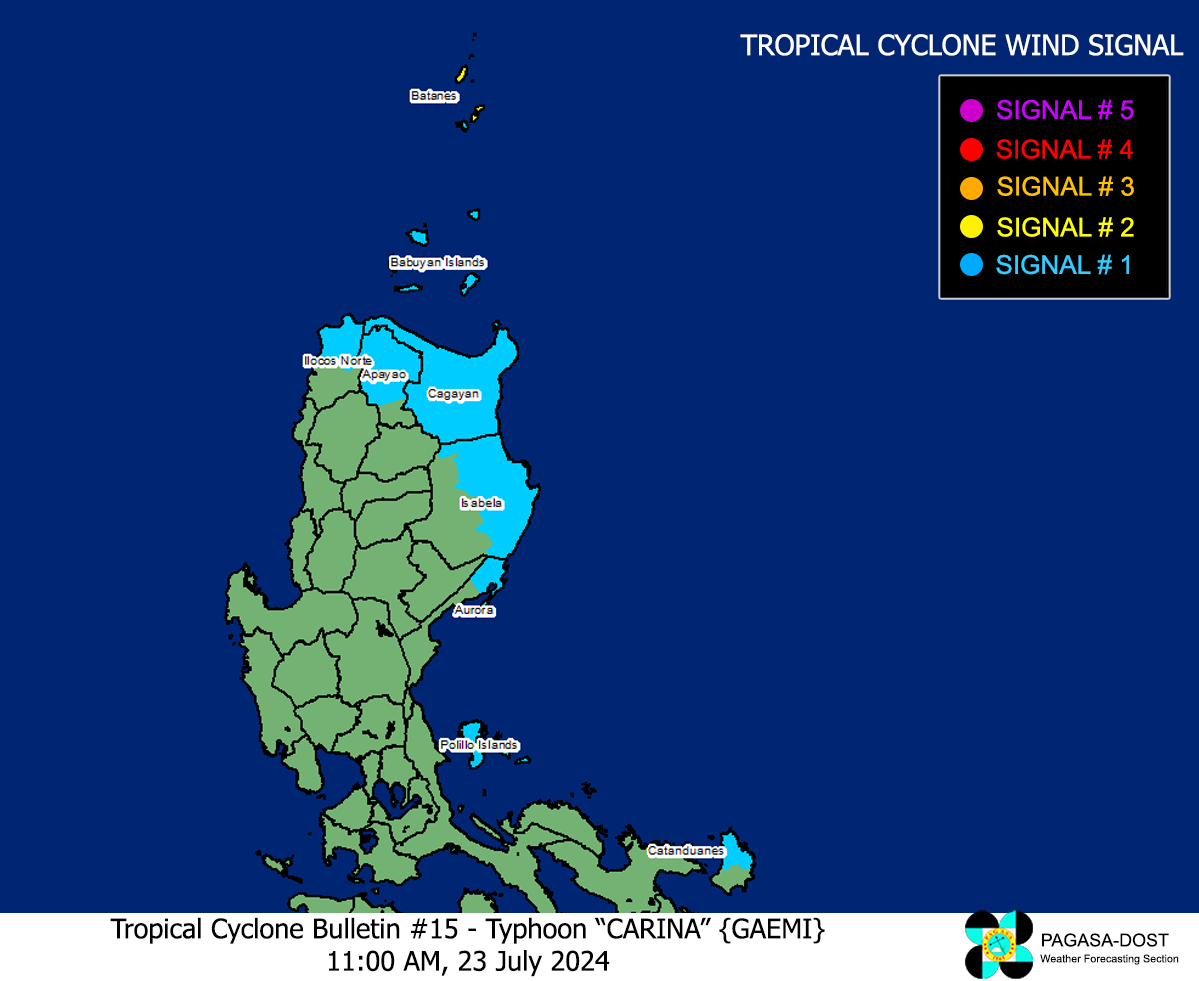
Image/Screenshot Source: DOST-PAGASA (https://bagong.pagasa.dost.gov.ph/tropical-cyclone/severe-weather-bulletin)

o

Issued by: David Michael V. Padua for Typhoon2000 (T2K)

CONTACT US

We're not around right now. But you can send us an email and we'll get back to you, asap.

Sending

©2024 Typhoon2000.

Log in with your credentials

Forgot your details?