
TROPICAL DEPRESSION AGHON (01W) ADVISORY NO. 03Issued at: 8:00 AM PhT (00:00 GMT) Saturday, 25 May 2024
Next update: 2:00 PM PhT (06:00 GMT) Saturday, 25 May 2024 |
|
|---|---|
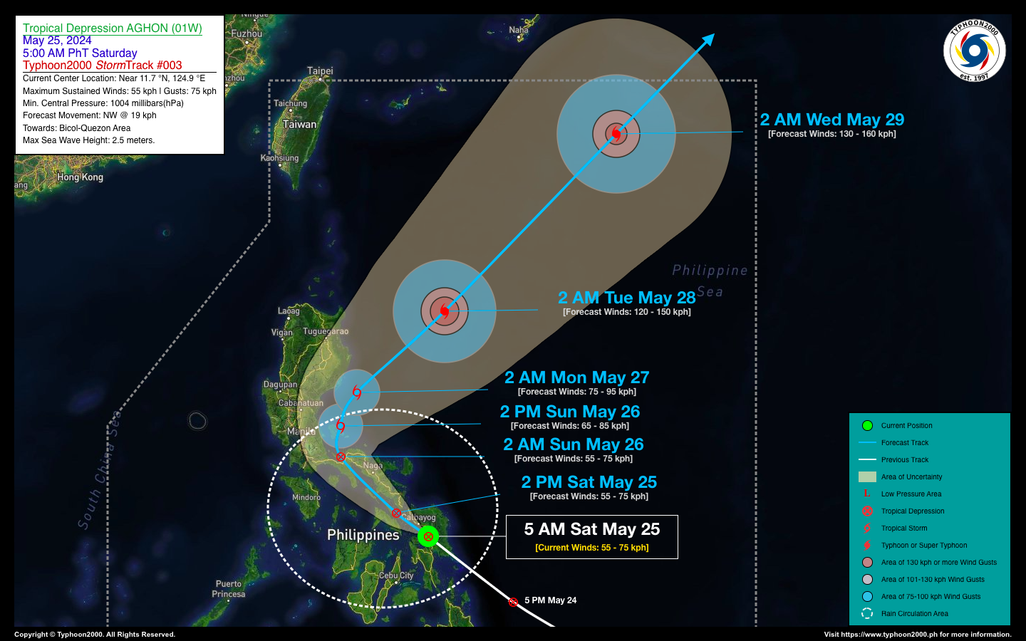
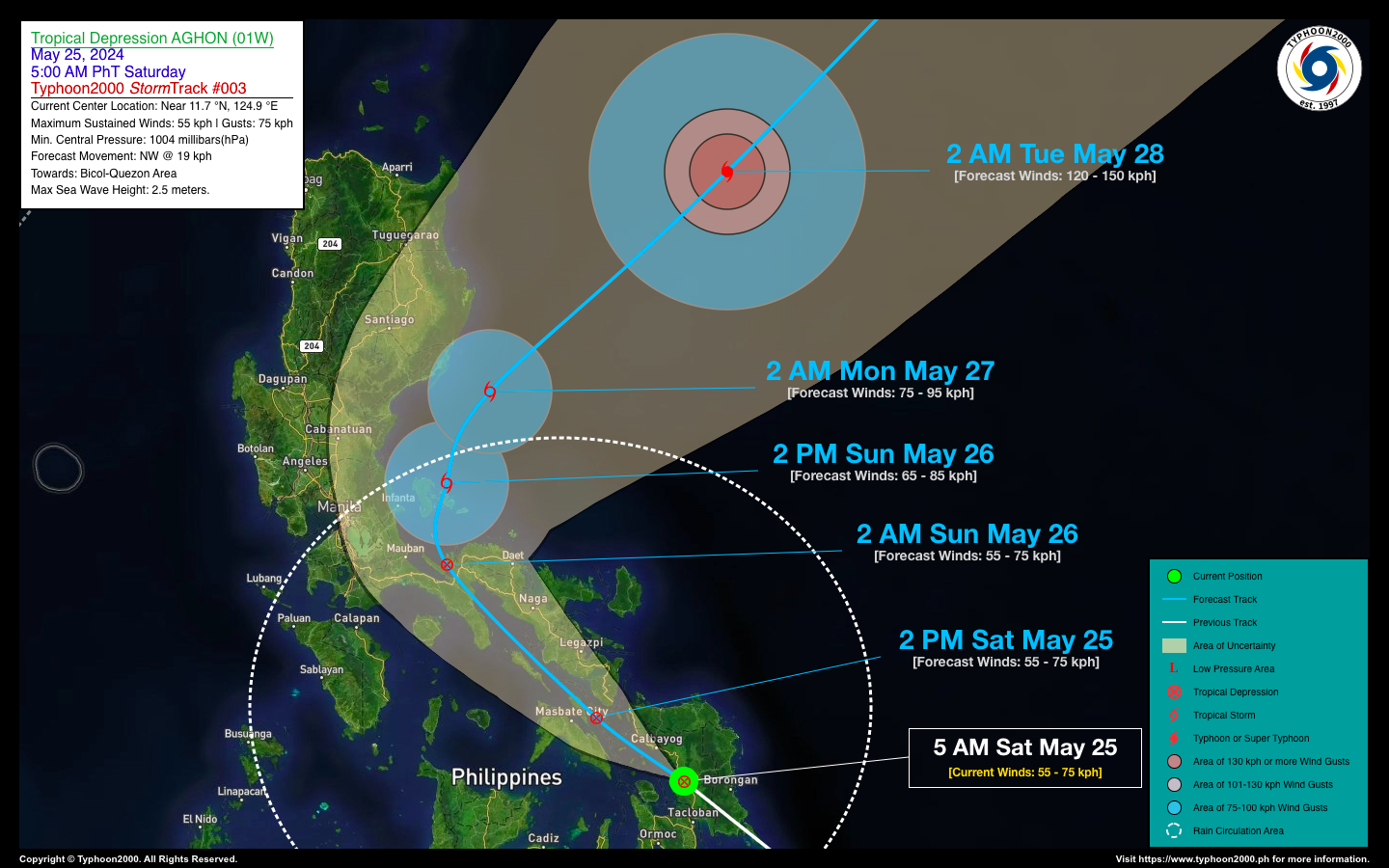
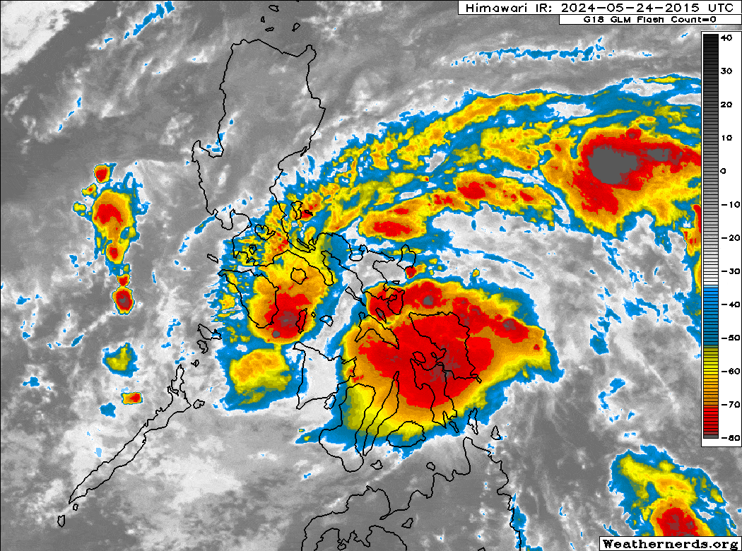
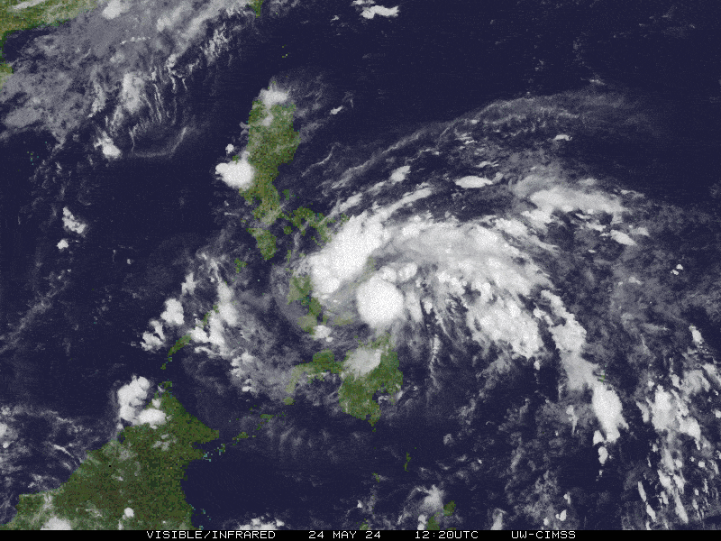
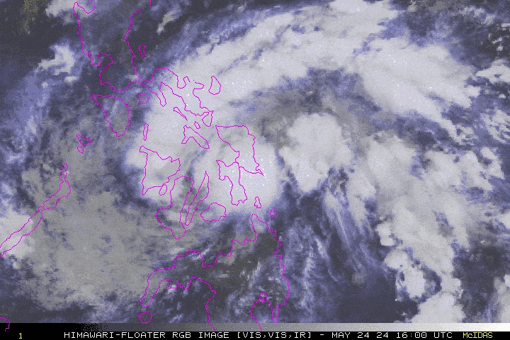
| Current Status & Outlook | Tropical Depression AGHON (01W) made landfall over Quinapondan, Eastern Samar early this morning. By 5 am, it had passed over Catbalogan City, Samar. As of now, the center is moving northwestward across the Samar Sea towards the Ticao-Masbate area. The inner rainbands of AGHON are currently bringing intense rainfall, gusty winds, and thunderstorms to Southern Bicol. These conditions pose a serious threat of flooding and landslides within the next 24 to 48 hours. Residents in these areas are urged to take all necessary precautions as the depression approaches
48-hr Outlook: AGHON is expected to maintain its strength as it moves across the Ticao-Masbate area this afternoon. Later this evening, it will likely pass over Ragay Gulf, Burias Island, and the coastal waters of Pasacao, Camarines Sur. By early tomorrow morning, the system is forecast to be near Alabat, Quezon, and will move over Polillo Island in the afternoon. AGHON is expected to intensify into a Tropical Storm as it continues northeast across the Philippine Sea by early Monday morning. Meanwhile, TD AGHON’s broad circulation and its Trough will continue to bring occasional moderate, heavy to intense rainfall with severe thunderstorms across Visayas, Southern & Central Luzon including Metro Manila, MiMaRoPa, and parts of Mindanao throughout the weekend. Please take all necessary precautions against floods and landslides including lahars that will be brought about by this tropical cyclone. |
| Where is AGHON (01W)? | As of 5:00 AM PhT today, May 25…2100 GMT:
|
| How strong is it? | Maximum Sustained Winds (1-min avg): 55 kph near the center…Gustiness: 75 kph. |
| Past Movement (06 hrs) | Northwest @ 28 kph, towards Bicol Region-Quezon Area. |
| Potential Philippine Major Landfall Area(s) |
|
| What Philippine areas will be directly affected? | Heavy to Extreme Rainfall (50 mm to >100 mm expected for 24 hrs):
Damaging Winds (gusts of more than 100 km/hr expected):
|
| Potential Storm Surge/Coastal Flooding Areas+ |
+Waves of 3 meters in height are expected in storm surge-prone areas, particularly in coastal areas where the Tropical Cyclone is headed. Kindly visit the PAGASA Storm Surge Updates for more details. |
| 3-Day Forecast Outlook Summary** |
**Important Note: Please be reminded that the Forecast Outlook changes every 6 hours, and the Day 2 and 3 Forecast Track have an average error of 100 and 250 km respectively… while the wind speed forecast error, averages 35 km/hr per day. Therefore, a turn to the left or right of its future track and changes in its wind speed must be anticipated from time to time. |
| Other Storm’s Meteorological Information |
|
| Disclaimer: Information based on data collected by Typhoon2000 (T2k) shall not be taken as official data. Weather information broadcasted and distributed by PAGASA remains as official data. Typhoon2000 (T2k) shall not be responsible for the private use and reliance of its weather information. | |
Issued by: David Michael V. Padua for Typhoon2000 (T2k)
Typhoon2000 (T2K) Integrated Multi-Agency Tracks
:: This section will be available once RSMC-JMA Upgrades this system into a Tropical Storm.
For more info visit: (http://www.typhoon2000.ph/multi/?name=)
PAGASA TROPICAL CYCLONE WIND SIGNAL
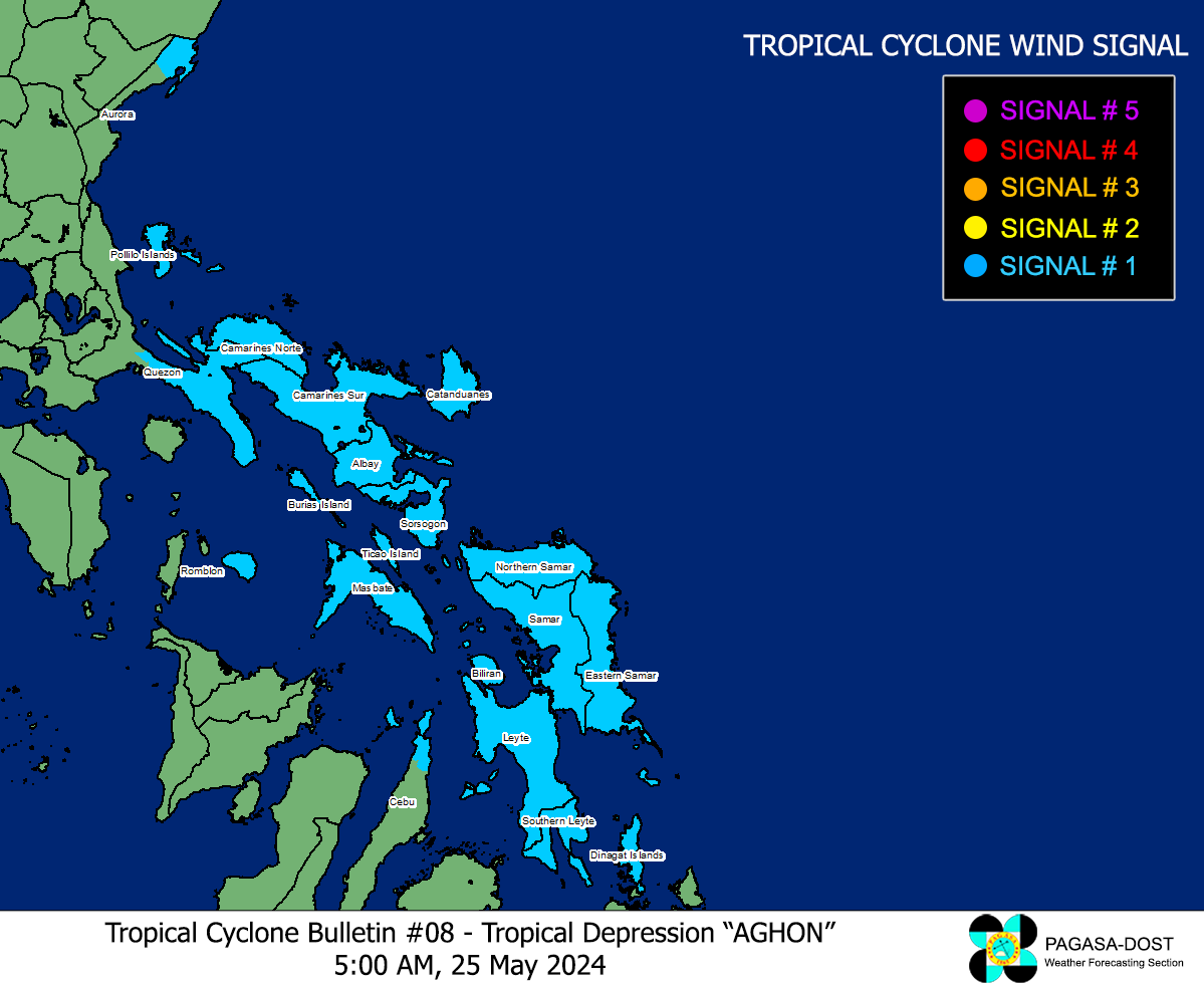
Image/Screenshot Source: DOST-PAGASA (https://bagong.pagasa.dost.gov.ph/tropical-cyclone/severe-weather-bulletin)


